FRANCE – CAP CERBERE TO RUISSEAU SAINT-LOUIS SECTOR 9
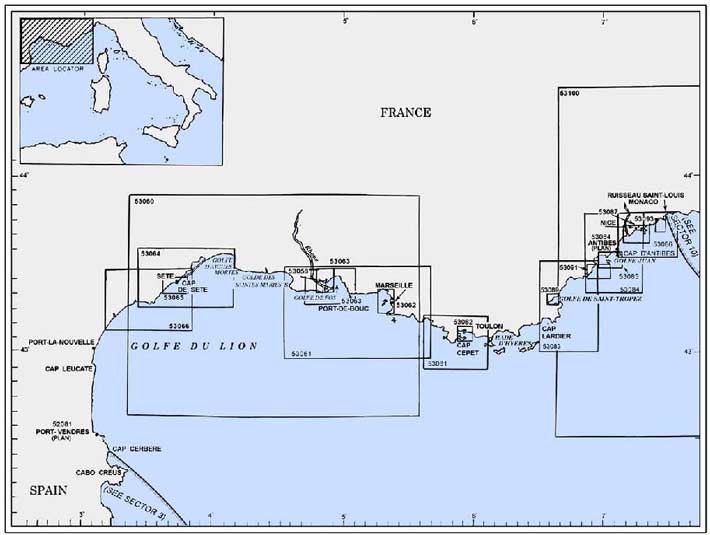
Plan. – This sector describes the S coast of France from Cap Cerbere (42°26'N, 3°11'E), at the Spanish -French boundary, to Ruisseau Saint-Louis (Fiume San Luigi) (43°47'N, 7°32'E), at the French -Italian boundary. The descriptive sequence is from W to E.
General Remarks
9.1 Winds – Weather. – The prevailing winds in this area are from the N and NW, especially in winter during the stormy season. Gales are rare in summer.
Golfe de Lion is notorious for bad weather and sudden changes. Strong NW winds, known as the Mistral, may frequently blow for a week and may even persist for a month in winter.
Fog is frequent, particularly during E winds, off the coast between Port-Vendres and Cap Leucate.
Tides – Currents. – The prevailing currents along this coast set W and SW, but they are generally weak and overridden by local surface currents caused by the winds.
After strong SE winds, a current usually sets W between Pointe du Sablon and the Golfe de Fos and may attain a rate of 3 knots.
Regulations. – Special regulations apply to tankers laden with hydrocarbons and to vessels carrying dangerous cargoes navigating in the approaches to French ports. For further details, see Pub. 140, Sailing Directions (Planning Guide) North Atlantic Ocean, Baltic Sea, North Sea, and the Mediterranean Sea.
Mandatory Access Channels and Waiting Areas, which are navigation controlled, lie in the approaches to several ports and are indicated on the charts. Tankers laden with hydrocarbons and vessels carrying dangerous cargoes, over 1,600 grt, are required to use these approach access channels and associated waiting areas. Special regulations apply to these vessels navigating in the Mandatory Access Channels. For further details, see Pub. 140, Sailing Directions (Planning Guide) North Atlantic Ocean, Baltic Sea, North Sea, and the Mediterranean Sea.
All vessels carrying hydrocarbons, including oil or other dangerous cargo, navigating within French territorial waters should maintain a continuous listening watch on VHF. A frequency or channel will be designated for this purpose by the local area traffic surveillance authority.
Caution. – Numerous fish havens and marine nature reserves extend from the coast within this sector.
French naval vessels are based at Toulon and are reported to carry out exercises along the coasts described in this sector. For further details, see Pub. 140, Sailing Directions (Planning Guide) North Atlantic Ocean, Baltic Sea, North Sea, and the Mediterranean Sea.
9.2 Cap Cerbere (42°26'N, 3°11'E) is formed by steep cliffs which rise abruptly to a plateau. It is the E termination of Chaine des Alberes, a rugged and prominent mountain range. From seaward, the cape has a triangular shape and its summit is surmounted by a small white building. A light is shown from a structure standing on the extremity of the cape. A radio tower is situated close W of the light.
Approaching the coast from the S or E of Cap Cerbere, vessels can readily identify the dark mass of Cabo Creus (42°19'N, 3°18'E). In addition, the two peaks of Dedos de Cadaques, standing 1.7 miles W of Cabo Creus, may be distinguished.
San Pedro de Roda, 689m high, stands 7 miles W of Cabo Creus and its summit is surmounted by some ruins. Mont de Cadaques, 610m high, stands 4 miles SW of Cabo de Creus. Both of these peaks are very prominent.
Le Canigou, 2,785m high, stands 30 miles NW of Cabo de Creus. It is snow-capped and prominent.
Anse Cerbere, a small cove, is entered between Cap Cerbere and Cap Canadell, 0.5 mile NW. It offers sheltered anchorage to small vessels from winds from the S through W to N. The holding ground is good, but local knowledge is advised. Two rocks, 2m high, lies close off Cap Canadell with no safe passage in the narrow channel between them and the cape. A village is situated at the head of the cove.
Anse de Terrambou, an open bay, is entered between Cap Canadell and Cap Peyrefite, 0.5 mile N, but is unsuitable for anchorage.
Cap l’Abeille is located 1.2 miles NNW of Cap Peyrefite. The coast between is high, rugged, and fronted by rocks. Tour de la Massane and Tour Madeloc, two prominent old towers, stand on peaks 5.7 miles and 3.5 miles WNW, respectively, of Cap l’Abeille.
9.3 Cap Dosne (42°29'N, 3°08'E) is located 1 mile WNW of Cap l’Abeille and is surmounted by a prominent yellow building.
Baie de Banyuls lies between Cap Dosne and Ile Grosse, a rock, 0.2 mile ESE. Ile Grosse, 7m high, is joined to the mainland by moles and breakwaters. The bay is divided into two parts by Ile Petite, 3m high. Anse de la Ville, the W part, fronts the town of Banyuls-sur-Mer. Anse de Fontaule, the E part, contains a yacht marina which is protected by breakwaters.
During N or NW winds, anchorage is available, in depths of 5 to 6m, weed, in Anse de la Ville, E of the town. Strong E winds raise a heavy sea. During offshore winds, moderate-size vessels can obtain good anchorage, in a depth of 12m, about 0.3 mile NE of Cap Dosne.
Caution. – A marine nature reserve, marked by yellow buoys, extends up to 0.8 mile seaward between Cap Peyrefite and Banyuls-sur-Mer. Fishing and dumping are prohibited within this reserve. Vessels are limited to a speed of 5 knots when within 300m of the shore, and to a speed of 8 knots elsewhere within the reserve.
9.4 Cap Castell (42°30'N, 3°08'E) is located 0.5 mile N of Cap Dosne and fronted by a detached perpendicular rock. Cap Oullestreil, a rugged and prominent headland, is located 0.5 mile N of Cap Castell. Anchoring is prohibited within 500m of the NE extremity of this cape.
Anse de Paulilles, a small bay, lies between Cap Oullestreil and Cap Bear, 1 mile NNE. A dynamite factory stands on a sandy beach at the head of this bay. An iron pier, with a depth of 5.5m at the outer end, fronts the factory. The bay offers shelter from N winds, but is exposed to heavy swell. The holding ground is mostly sand, except for Roche La Lioze, a rock, with a depth of 4.7m, which lies in the middle of the bay.
Cap Bear (42°31'N, 3°08'E), located 5 miles NNW of Cap Cerbere, is the E extremity of a rocky promontory which terminates in a vertical black cliff, 9m high. The rugged terrain rises from this cliff to a height of 56m, about 0.3 mile inland. Fort Bear, an old fortress, stands on the summit of the promontory.
A light is shown from a tower, 23m high, standing 0.2 mile W of the extremity of the cape. A signal station, consisting of a prominent white building, is situated close W of the light. A radiobeacon is located at the light.
Caution. – Numerous wrecks lie within 6 miles of Cap Bear.
Due to the existence of submarine cables, an anchoring and trawling prohibited area, the limits of which are shown on the chart, lies in the vicinity of Cap Bear. The area is 1.5 miles wide and extends up to about 5.5 miles ESE of the cape,and up to 11 miles N of the cape.
Port-Vendres (42°31'N, 3°07'E)
World Port Index No. 38720
9.5 Port-Vendres, a small port, lies 1.3 miles WNW of Cap Bear and provides good shelter from sea and swell.
Winds – Weather. – The strongest winds in this vicinity are those from the NW, E, and SE. Storms often accompany strong E and SE winds. The high hills, which rise abruptly near the harbor, generally shield the area, but strong NW winds sometimes sweep through the gap in these hills and hinder navigation.
Tides – Currents. – Tides are nearly negligible and rise about 0.4m at springs and 0.3m at neaps. They may be affected by the wind.
Off the port, the general set of the current is SE and it may attain a velocity of 5 knots after a long period of strong N winds. Even with strong winds against it, a velocity of 2 knots may still be maintained. However, the effect of the current is not felt more than 1 or 2 miles seaward of the harbor.
Depths – Limitations. – Mole Abri, a breakwater, extends 250m NW from the shore. The harbor is entered between the head of Mole Abri and Pointe du Fanal, 300m SW. A yacht basin is situated in the S part of the harbor.
There is 798m of total commercial quayage, with depths of 6 to 8m alongside, and facilities for ro-ro vessels. Vessels up to 155m in length and 8m draft can be accommodated.
Aspect. – The harbor lies at the foot of the E ranges of the Pyrenees, and vessels approaching from seaward in fine weather can distinguish these mountains from a great distance. The coast to the N of the harbor is low and flat.
Prominent landmarks include Fort Saint-Elme, which stands on a hill 0.5 mile W of the harbor, and Redoute du Fanal Light, which stands on the W side of the harbor entrance.
A lighted range indicates the entrance channel.
Pilotage. – Pilotage is compulsory for vessels over 45m in length. Pilots can be contacted on VHF channel 12 or 16 and generally board about 1 mile N of Mole Abri Light on the lighted range. Vessels should send an ETA 18 hours in advance through Marseille (FFM), and then contact the pilot 1 hour before arrival on VHF channel 12.
Anchorage. – Anchorage may be obtained within a designated area, the limits of which are shown on the chart, lying N of the breakwater. The area has good holding ground, in a depth of 40m.
Caution. – During N winds, the current sets SE and vessels should keep slightly W of the range line.
The seaward end of the breakwater should be given a wide berth.
Foul anchorage areas and anchoring and dredging prohibited areas, the limits of which are shown on the chart, lie in the approaches to the harbor.
Port-Vendres to Port La-Nouvelle
9.6 Cap Gross (42°32'N, 3°06'E), located 0.5 mile WNW of Port-Vendres harbor entrance, is high and rugged.
Baie de Collioure lies between Pointe del Mich, located 0.7 mile W of Cap Gross, and Presqu’ile Saint Vincent, a small islet lying 1.8 miles NW. A breakwater projects from the SE extremity of this islet and connects it to the shore. A prominent chapel stands on the summit of the islet, and a conspicuous citadel is situated at the head of the bay.
During SW to N winds, the bay offers temporary anchorage, in a depth of 6m, to small vessels with local knowledge, but it is dangerously exposed to strong winds from the NE to ESE.
From Presqu’ile Saint-Vincent to Cap Leucate, 24 miles N, the bottom is generally formed of sand, or sand and mud.
Fog is frequent along this stretch of coast, particularly during E winds. In bad weather it is advisable for vessels to navigate in depths of more than 25m.
Fishing and yacht harbors are situated at Massane, Saint Cyprien, Canet-Plage, Barcares de Saint Laurent, Grau Saint Ange, and Port Leucate, which lie 1.8 miles, 6 miles, 11 miles, 16 miles, 16.5 miles, and 23 miles N, respectively, of Presqu’ile Saint-Vincent.
Landmarks along this stretch of coast, which can be easily identified, include a square steeple standing at Argeles, 3 miles N of Presqu’ile Saint Vincent; a church, with two towers, situated 4 miles farther NW; a conspicuous watch tower standing close NW of Canet-Plage; a tower standing 1 mile SE of Canet-Plage; the resort buildings situated at Canet-Plage and Saint Cyprien; and a high tower, surmounted by belfries, standing at Perpignam, 5 miles W of Canet-Plage.
A light is shown from a structure, 24m high, standing 0.3 mile N of Canet-Plage harbor. An aeronautical light is situated 7 miles WNW of the light.
Cap Leucate (42°55'N, 3°04'E) is prominent, whitish, and flat-topped. It rises steeply from the sea to a height of 52m. A light is shown from a structure, 17m high, standing 0.5 mile S of the cape. Fort des Mattes, a small disused building, stands close S of the light.
Caution. – A rectangular area of underwater obstructions lies about 2 miles NE of Canet-Plage harbor entrance.
A conspicuous stranded wreck, painted white and illuminated at night, lies about 100m offshore, 2.5 miles N of Bar-cares de Saint Laurent. This wreck is situated on a S heading and should not be mistaken for a vessel at sea or at anchor.
Port-La-Nouvelle (43°01'N, 3°04'E)
World Port Index No. 38730
9.7 Port-La-Nouvelle, a small port, lies 6 miles N of Cap Leucate. It is formed by a canal, with several open basins, which connects Etang de Sigean to the sea. An offshore oil terminal is situated close ENE of the harbor entrance.
Tides – Currents. – With NW winds, the water level can decrease by up to 0.4m. With winds from the SE, the water level can increase by up to 0.5m. An increase of 1.5m was recorded with sustained strong SE winds.
Depths – Limitations. – The entrance channel is dredged to a depth of 8.7m. The canal leading to Etang de Sigean is 1.2 miles long. It has a surface width of 61m and a bottom width of 30.5m. The dredged depth is generally maintained at 6.3m from June to September, but onshore winds cause silting and the depth is variable. A fishing harbor and a yacht marina lie at the W end of the canal.
The open basins at the E end of the canal have 740m of total berthing space, with a depth of 8.7m alongside. Vessels up to 145m in length, 22m beam, and 8m draft can be accommodated.
An oil berth, consisting of several mooring buoys, lies 1 mile seaward of the harbor. A submarine pipeline extends from the berth to a point on the shore, close N of the harbor entrance. A lighted buoy is moored close W of the berth. It is reported that vessels up to 40,000 dwt, 200m in length, and 12m draft can be handled.
Aspect. – The buildings of the town situated on the S side of the canal are conspicuous. The sanitarium standing close inside the entrance on the N side is prominent. In addition, numerous oil tanks are situated on either side of the harbor entrance.
A light is shown from a structure, 17m high, standing on the S jetty head of the harbor entrance.
Pilotage. – Pilotage is compulsory for vessels over 45m in length. Pilots can be contacted on VHF channel 12 or 16 and generally board about 0.5 mile off the harbor entrance. Vessels should send an ETA 18 hours in advance through Marseille (FFM) and contact the pilot 1 hour before arrival. Vessels over 1,600 grt, carrying hydrocarbons or dangerous cargoes should notify the Port Captain by telex, 24 hours in advance.
Regulations. – A Mandatory Access Channel, the limits of which are shown on the chart, lies in the approaches and is entered 6 miles ESE of the harbor entrance. All vessels over 1,600 grt, carrying hydrocarbons or dangerous substances, must report their entry into this channel and maintain a listening watch on VHF. For further information, see paragraph 9.1.
Anchorage. – There is temporary anchorage, in a depth of 8m, sand, about 0.5 mile ENE of the harbor entrance, remaining well clear of the submarine pipeline. If the wind shifts to E or SE, vessels should leave this roadstead at once.
Caution. – During strong SE winds from the NE through SE, the sea sometimes breaks a short distance off the entrance and makes entry difficult.
A prohibited anchorage area is situated adjacent to the S side of the access channel and centered 1.5 miles SSE of the harbor entrance.
9.8 Grau de la Vieille Nouvelle (43°04'N, 3°05'E), marked by an old tower and several houses, is situated 2.7 miles NNE of Port La-Nouvelle.
An area of obstructions, covered by a depth of 8m, lies about 0.6 mile SE of Grau de la Vieille Nouvelle.
Gruissan-Plage, an extensive yacht harbor, is situated 3.5 miles NNE of Grau de la Vieille Nouvelle and is protected by two moles, A prohibited area, the limits of which are marked by buoys, lies centered 1.5 miles SE of the harbor entrance.
A submarine pipeline extends 2 miles ESE from a point on the shore, 1.2 miles NNE of Gruissan-Plage.
Le Pech Rouge, a shoal patch, lies nearly 1 mile NE of the root of this pipeline and is marked by a lighted beacon.
Port de Narbonne-Plage, an extensive yacht harbor, is situated 4 miles NE of Gruissan-Plage and is protected by two breakwaters. A rectangular prohibited area lies 3 miles E of the harbor entrance.
Rocher St. Pierre (43°11'N, 3°11'E), located close NE of Port de Narbonne-Plage, is 5m high and surmounted by the sand-covered ruins of a battery. It is the most distinctive mark in this vicinity.
A prohibited area, marked by lighted buoys, lies E of Rocher St. Pierre.
A conspicuous radar tower, 25m high, stands 3.2 miles W of Rocher St. Pierre and is surmounted by a dark green dome. A water tower stands 0.5 mile WSW of Rocher St. Pierre and also is conspicuous.
Valras-Plage, a resort, is situated at the mouth of the River Orb, 6.5 miles NE of Rocher St. Pierre. A yacht and fishing craft harbor is situated within the river mouth. A casino and a large water tower stand in this vicinity and are excellent landmarks from seaward.
Vias, a town, is situated 1.5 miles inland, 6.2 miles NE of Valras-Plage. A black pointed steeple, with a water tower close N, and a large white mansion stand in the town and are conspicuous from seaward.
9.9 Cap d’Agde (43°16'N, 3°31'E), low and rocky, is located 9.5 miles ENE of Valras-Plage. Montagne du Gros Frere, 848m high, stands 29 miles N of the cape and may be sighted on a clear day from a considerable distance to the S. Mont d’Agde, 115m high, stands 1.5 miles NNW of the cape. It is isolated and conical and can easily be identified at a distance of 12 miles.
Between the cape and the mouth of the River Herault, 3 miles W, the coast is fronted by rocks and rocky points. Pointe de Roche Longue, located midway along this stretch, is surmounted by an old battery. Two radio masts stand 1 mile N of the battery and are prominent.
The town of Agde is situated 2 miles above the entrance to the River Herault and is fronted by depths of 3 to 6m. Small craft with local knowledge use the river.
An outfall pipeline extends 2 miles S from a point on the shore, 0.5 mile E of the river entrance.
Port Cap d’Agde, a small harbor, is situated close W of Cap d’Agde. It is protected by two breakwaters and used by yachts and fishing craft.
Ilot Brescou, formed by a flat rock, lies 1 mile SW of Cap d’Agde and is surmounted by the grey structure of Fort Brescou. A light is shown from a structure, 11m high, standing at the S corner of the fort. This islet is surrounded by dangers and foul ground.
Port Amboune, a small yacht harbor, is situated 1.2 miles NNE of Cap d’Agde and is protected by two breakwaters.
Port Marseillan Plage, a small harbor, lies 2 miles NNE of Port Amboune and is protected by two jetties. A canal, with a depth of 2m, connects the harbor with Etang de Thau, a lagoon.
Quilles, a small yacht harbor, is situated 6.5 miles NE of Port Marseillan Plage. It lies on the SW side of Mont Saint Clair and is protected by breakwaters. The coast between consists of a low and narrow beach which separates Etang de Thau from the sea. A range of hills stands on the N side of the lagoon.
During W and NW winds, vessels can anchor, in 5 to 6m, sand and rock, poor holding ground, ENE of Cap d’Agde.
Caution. – Several prohibited areas (fish havens), the limits of which may be seen on the chart, lie NE of Cap d’Agde and are marked by lighted buoys.
A prohibited anchorage area, marked by lighted buoys, lies about 1.2 miles SE of the harbor entrance.
World Port Index No. 38750
9.10 The port of Sete lies 11 miles NE of Cap d’Agde and consists of three sections. An outer harbor and a series of connecting basins and canals in the N part, an industrial zone within Etang de Thau, and an offshore terminal berth.
Port of Sete Home Page http://www.sete.port.fr
Winds – Weather. – The prevailing winds are NW, but SE winds, often accompanied by violent storms in the open sea, are frequent. Calms are rare in Golfe du Lion.
Tides – Current. – The sea level in the harbor normally does not vary more than 0.2m, but variations of 1m have been observed.
The current generally sets SW off the harbor entrance and can attain rates of 1 to 3 knots.
Within the harbor, currents attaining rates of 3 to 4 knots may occur due to the movement of the waters of Etang de Thau. Fresh NW winds increase the flow of these currents out of the lagoon; winds from seaward usually act in the opposite direction.
Depths – Limitations. – The port is enclosed by breakwaters, including a detached one which protects the harbor from the S.
Pass de l’Ouest, the W entrance channel, is shallow and partly obstructed. It can only be used by small craft with local knowledge. Passe de l’Est, the E and main entrance channel, lies between the detached breakwater and the new E breakwater which extends 1 mile S from the shore. The outer part of this entrance channel was dredged to a depth of 14.5m.
A channel leads N from the port of Sete to the industrial zone on the E shore of Etang de Thau. It is dredged to a depth of 7.5m and is marked by buoys and range beacons. Nearly the whole of this E shore of the lagoon is lined with quays, behind which are several factories.
The main commercial basins in the port include Canal Maritime, with 1,953m of total quayage; Nouveau Bassin, with 380m of total quayage; Avant-Orsetti Bassin, with 920m of total quayage; Bassin aux Petroles, with 400m of total berthing space; Colbert Dock, with 777m of total quayage; and Darse 2 Dock, with 700m of total berthing space, including dolphins.
There are facilities for ro-ro, bulk, general cargo, passenger, cruise, tanker, car ferries, ore carriers, chemical tankers, livestock carriers, forest product carriers and fishing vessels within the port.
Vessels up to 145m in length, 20m beam, and 6.8m draft can be accommodated alongside the berths in Canal Maritime. The channel is reduced to a width of 26m by a bridge.
The outer basins have depths of 9 to 14.5m alongside. Tankers up to 35,000 dwt, 225m in length, and 11m draft can be accommodated. Other vessels up to 60,000 dwt, 260m in length, and 13.1m draft can be accommodated.
The Northern Unloading Station, an offshore oil terminal consisting of a multiple buoy mooring, lies 0.6 mile NE of the E head of the detached breakwater. A submarine pipeline extends NNE from the berth to the shore. This terminal can handle tanker vessels up to 100,000 dwt, with lightened drafts up to 13.1m.
Aspect. – The harbor lies at the foot of the E slope of Mont de Sete (Mont Saint-Clair). This hill, 180m high, dominates the area and is covered by houses. A television mast, a cross, and a statue stand near its summit.
A light is shown from a structure, 19m high, standing on the SE slope of the hill. Citadelle Richelieu, with a signal station at its S end, is situated close NE of the light.
Montagne de la Gardiole, 180 to 240m high, extends between 4 miles and 10 miles NE of the town and terminates in a distinctive peak surmounted by a prominent chapel. The chimneys of an industrial zone, standing at the foot of this range, can be seen to the NNE of the port. A flare, a large square steeple, and numerous oil tanks are situated at Frontignan, 3.5 miles NE of the port. A noticeable quarry lies 1 mile N of Frontignan. A conspicuous steeple, surmounted by a golden figure of the Virgin, stands in Sete, near the harbor.
A lighted approach buoy is moored about 12 miles SE of the harbor entrance.
A sector light is shown from a structure standing in the SW part of the harbor and aids in the approach to the entrance.
Pilotage. – Pilotage is compulsory for vessels over 50m in length beyond the Victoire Bridge and for vessels over 55m in length up to the Victoire Bridge. Pilots can be contacted on VHF channel 12 at least 1 hour before arrival at the boarding station.
The pilotage area is bounded by a circle, with a radius of 6 miles, centered on the light at the E end of Epi Dellon. In good weather, pilots will board 2.7 miles SE of Epi Dellon. In bad weather, pilots will give instructions to board in the shelter of Epi Dellon. Entry may be suspended at night in bad weather. Pilots will also board tanker vessels within the compulsory access channel, about 4 miles SE of the old pipeline lighted buoy.
Regulations. – Vessels should send ETA messages 24 hours in advance. Any change in ETA of more than 1 hour should be reported.
A Mandatory Access Channel, with compulsory approach and departure routes for all tanker vessels, extends between the port and the outer approach lighted buoy and may best be seen on the chart.
Inbound vessels should keep NE of the centerline; outbound vessels should keep SW of it.
Tankers navigating within this compulsory approach and departure access channel are considered to be restricted in their ability to maneuver and must show the prescribed lights and shapes accordingly. Vessels other than tankers are prohibited from entering or anchoring within the area without permission of the authorities.
All vessels over 1,600 grt, carrying hydrocarbons or dangerous substances, must report their entry into the access channel and maintain a listening watch on VHF channel 16. For further information, see paragraph 9.1.
Anchorage. – An anchorage area, the limits of which are shown on the chart, extends 3 miles S from the S side of the detached breakwater.
Caution. – A dangerous wreck was reported (1994) to lie about 0.5 mile NE of the E head of the detached breakwater.
Several restricted areas, the limits of which are shown on the chart, are situated in the approaches to the port.
9.11 Port de Peche de Frontignan-Le Peyrade (43°25'N, 3°45'E), a small harbor, lies 1.5 miles NE of the main entrance to Sete harbor. It is protected by breakwaters and forms the entrance to Canal du Rhone a Sete.
Frontignan, an extensive yacht harbor, lies 3 miles NE of the harbor entrance at Sete and is protected by breakwaters. A prohibited area (fish haven) is centered 4 miles ENE of the harbor and is marked by lighted buoys.
The ruins of a church are situated at Maguelonne, 6.7 miles NE of Frontignan. They are surrounded by a pine forest and are conspicuous from seaward. Mont Bouzille, 197m high, stands 3.5 miles WNW of the ruins and is surmounted by a conspicuous ruined chapel.
Palavas Les Flots (Grau de Palavas) (43°32'N, 3°56'E), a small harbor, lies 2.3 miles NE of Maguelonne and is protected by a breakwater. It is mostly used by small craft and yachts. The entrance is surrounded by a prominent group of buildings and a conspicuous water tower stands close NE of it.
 |
Maguelonne Church and the summit of Mont Bauzille, bearing 294° |
An aeronautical light is shown from a control tower standing 3.5 miles NNE of the harbor.
An area of floating and submerged objects, the limits of which is shown on the chart, lies 2 miles SE of the harbor entrance.
Golfe d’Aigues-Mortes (43°30'N, 4°05'E) lies between Palavas Les Flots and Pointe de L’Espiguette, 9 miles ESE.
Grau de Perols, a small harbor, lies 2 miles ENE of Palavas Les Flots and a continuous line of buildings is situated between them. This harbor is protected by breakwaters and bordered by several high prominent buildings.
A prominent church tower standing at Mauguio, 6 miles NE of the harbor, is visible from seaward.
La Grande Motte, a yacht harbor, lies 5 miles ENE of Grau de Perols. It is protected by two breakwaters and can be identified by the pyramid-shaped buildings standing in its vicinity.
Le Grau du Roi, a small harbor, lies 2.5 miles SE of La Grande Motte and close within the seaward end of the canal which leads to Aigues-Mortes. The harbor is entered between two jetties and is mostly used by fishing craft and yachts. A conspicuous water tower stands 1 mile NNW of the entrance.
A dangerous wreck has been reported to lie 1.5 miles WSW of the harbor.
Port Camargue, an extensive yacht harbor, lies 1 mile SSW of Le Grau du Roi and is protected by two breakwaters. Two jetties, situated 0.7 mile S of the entrance to the harbor, extend seaward and form the entrance to a shallow canal.
Rocky banks and ledges, which are dangerous for anchoring, lie parallel to the N shore of the gulf and extend up to 1.5 miles offshore into depths of 14 to 20m.
During calms or NW winds, anchorage can be obtained in greater depths outside of these rocky banks; however, anchorage within this gulf is not considered safe.
9.12 Pointe de l’Espiguette (43°29'N, 4°08'E) is reported to be extending to the W by about 15m a year. Depths of 5m have been reported to lie up to about 1 mile offshore in this vicinity, and this part of the coast should be given a wide berth.
Les Baronnets, 10m high, is a chain of prominent sand dunes which extends along the coast near Pointe de l’Espiguette A light is shown from a prominent structure, 25m high, standing on the point. An old signal station tower is situated close NW of the light.
 |
Pointe de l’Espiguette Light |
Lighted buoys, which mark the edge of the coastal shoal bank, are moored about 1.5 miles W and 1.5 miles S of the light.
Caution. – Between Pointe de L’Espiguette and the Golfe de Fos, 33 miles E, the shore is very low. It is bordered by lagoons and has very few landmarks. It is reported that the radar images of Cap Couronne (43°20'N, 5°03'E) is the E entrance point of the gulf. A light is shown from a structure, 29m high, standing on the cape. A prominent signal station stands on a hill, 0.5 mile N of the cape. The breakwaters and many canals are more distinct than the outline of the shore itself.
Numerous dangerous wrecks lie off this stretch of the coast and may best be seen on the chart.
9.13 Saintes-Marie-de-la-Mer (43°27'N, 4°26'E), a small town, is situated 13.5 miles E of Pointe de l’Espiguette. The coast between is low, flat, and not easily distinguished. In very clear weather, this town, which is dominated by its church, is visible from a distance of about 7 or 8 miles and appears as an isolated hillock.
The mouth of the Petit Rhone forms a break in the coastline, 12 miles E of Pointe de L’Espiguette. Depths of 1.6m lie in the river mouth, but it is liable to silt.
Port Gardian, a small yacht harbor, lies 1 mile E of the river mouth and is protected by two breakwaters.
Golfe des Saintes-Maries (Golfe de Beauduc) (43°24'N, 4°34'E) has low and sandy shores which are backed by sand dunes, 6 to 7m high. It is entered between Saintes-Maries-dela-Mer and Pointe de Beauduc (Pointe du Sablon), 8 miles ESE.
A light is shown from a structure, 18m high, standing 6 miles E of Saintes-Maries-de-la-Mer.
Pointe de Beauduc (Pointe du Sablon) (43°22'N, 4°34'E) is reported to be extending NW at about 15m a year and should be given a wide berth. A light is shown from a structure, 25m high, standing 1.5 miles SE of the point. Lighted buoys, marking the coastal bank, are moored about 1.5 miles SW and 4 miles SE of the light.
Vessels can take anchorage in Golfe des Saintes-Maries to the N of Pointe de Beauduc. The roadstead is sheltered from E winds and has depths of 10 to 12m, muddy sand, good holding ground. Local knowledge is advised.
Caution. – An anchoring and dredging prohibited area, the limits of which are shown on the chart, extends NW of Pointe de Beauduc.
Several wrecks, some dangerous to navigation, lie up to 2.5 miles offshore between Pointe de Beauduc and the mouth of the River Rhone.
9.14 Faraman (43°22'N, 4°40'E) is located 5.5 miles E of Pointe de Beauduc. The coast between is reported to be receding slowly. A light is shown from a structure, 43m high, standing at Faraman. Piemanson Lighted Buoy, marking the coastal bank, is moored about 3.7 miles SE of the light.
Along this coast the current generally sets W and parallel to the shore. After strong E or SE winds, it sometimes attains a rate of over 3 knots.
Grau de Roustan (43°20'N, 4°50'E), through which the main branch of the River Rhone discharges, lies 7 miles E of Faraman. The river carries a whitish sediment which discolors the sea up to 6 miles off its mouth.
A beacon stands on the E bank of the river near the mouth. A lighted buoy, with a spar buoy close W of it, is moored about 1.5 miles S of the beacon and indicates the river bar.
The banks formed around the mouth of the river are reported to be advancing seaward at a rate of about 50m per year.
9.15 Golfe de Fos (43°23'N, 4°57'E) lies between the mouth of the River Rhone and Cap Couronne, 9 miles E.
The E shore of the gulf is dominated by Collines de Martigues. These hills, when viewed from seaward, appear to descend from Chain des Alpilles, a mountain range standing 20 miles inland.
Cap Couronne (43°20'N, 5°03'E) is the E entrance point of the gulf. A light is shown from a structure, 29m high, standing on the cape. A prominent signal station stands on a hill, 0.5 mile N of the cape.
The W and N shores of the gulf are low, difficult to distinguish, and liable to change; the coast then rises progressively towards the E shore, where it becomes rocky and steep.
Port-Saint-Louis-du-Rhone, Fos, Port-de-Bouc, and Lavera are situated within the gulf. It also provides access to the Rhone, via Canal Saint-Louis, and to Etang de Berre, via Canal de Caronte. Because of the bar at the mouth of the River Rhone, vessels bound for Port-Saint-Louis-du-Rhone or farther up the river generally proceed from the gulf through Canal Saint-Louis, which is connected to the River Rhone by a lock.
Marseille-Fos is the name given to the group of ports which are controlled by the Marseille Port Authority. This port complex extends from the mouth of the River Rhone to Marseille, 23 miles E, and consists of the above-named ports, Marseille, and their associated industrial areas.
Tides – Currents. – The gulf is open to the S and strong SW and SE winds usually result in a heavy sea. Moderate shelter from W and SW winds can be found in the W part of the Golfe de Fos. The current is generally weak and its velocity and direction is determined largely by the wind.
Aspect. – They de la Gracieuse is the low bank on the E side of the River Rhone, which extends 4.5 miles NE of the river mouth. Several stranded wrecks lie close to the shore of this bank. The bar at the mouth of the River Rhone advances about 50m seaward each year.
The coastal shoal off They de la Gracieuse is marked by lighted buoys moored about 0.5 mile N, 1.2 miles SSE, and 2.5 miles S of the NE extremity of the bank. In addition, Lighted Buoy GE, equipped with a racon, is moored about 0.5 mile E of the NE extremity of the bank.
Landmarks on the W side of the gulf include several prominent chimneys situated in an industrial area on the S side of the Canal St. Louis, and several container gantry cranes, standing at the Fos basin terminal.
Landmarks on the N side of the gulf include the refinery situated 1 mile NW of Fos-sur-Mer, and a cement factory, with two conspicuous chimneys, situated 1 mile E of Fos-sur-Mer.
At the E side of the entrance to the gulf, the coastal shoal is marked by lighted buoys moored about 1 mile W and 1.2 miles WNW of Cap Couronne.
Landmarks on the E side of the gulf are numerous and the following can be easily identified:
- A conspicuous white viaduct, with six arches, standing W of the village of La Couronne.
- Four conspicuous chimneys standing near the shore, 2.5 miles NW of Cap Couronne.
- A large tower standing on Fort de Bouc, at the S entrance to Port de Bouc.
- The prominent chapel at Misericorde, which stands on the summit of a hill, 5.5 miles N of Cap Couronne.
- A prominent chimney standing 1 mile WSW of the chapel.
- Two pylons, 95m high, standing 0.7 mile S of the chapel.
- Several flares situated in the vicinity of a refinery close SE of Lavera.
- The loom of Port de Bouc, which can be seen for up to 40 miles seaward.
Port de Carteau, a small harbor, lies on the SW side of the gulf, 0.5 mile S of the entrance to Canal de Saint Louis. It is mostly used by fishing craft and the entrance is indicated by a lighted range.
Anse de Lauron is entered 2.5 miles SSE of Port de Bouc. An angled jetty extends 0.2 mile SW and SE from the N entrance point of this bay.
Port de Carro, a small harbor, lies 2 miles SSE of Anse de Lauron and 0.5 mile WNW of Cap Couronne. It is used by small craft with local knowledge.
A light is shown from a tower standing at St. Gervais, at the head of the gulf. Omega Outer Approach Lighted Buoy, equipped with a racon, is moored about 7.5 miles S of Cap Couronne.
Pilotage. – The pilotage zone for the Golfe de Fos is bounded by latitude 43°19'N and the meridians of Cap Couronne and Faraman Light. Pilotage is compulsory for vessels over 50m in length within this zone. Vessels should send an ETA through Marseille (FFM) 24 hours in advance. Pilots can be contacted on VHF channel 12 or 14 and generally board deep-draft vessels W of Cap Couronne. Other vessels may be boarded closer in. Vessels bound for Port-de-Bouc-Lavera, L’Etang de Berre, and Port Saint-Louis-du-Rhone are boarded 2.5 to 4 miles S of Lavera Lighted Buoy. Vessels, other than deep draft, bound for Fos are boarded 2.5 miles S of Lavera Lighted Buoy.
Regulations. – An approach zone (regulated area), the limits of which are shown on the chart, has been established off the Golfe de Fos. Within this zone, the movement of all vessels is regulated by the Port Authority at Port de Bouc.
A Mandatory Access Channel, the limits of which are shown on the chart, lies in the approaches and is entered 7.5 miles S of Cap Couronne, in the vicinity of Omega Outer Approach Lighted Buoy.
Inbound vessels should keep to the E of the centerline and outbound vessels should keep W of it.
All vessels over 1,600 grt, carrying hydrocarbons or dangerous substances, must report their entry into this channel and maintain a listening watch on VHF. For further information, see paragraph 9.1.
A Vessel Traffic Management System (VTMS) has been established in the approaches to the Golfe de Fos and is coordinated by the Centre de Regulation Integre (CRI) at Port de Bouc (call sign Fos Port Control). It is mandatory for all commercial vessels navigating within the approach zone, the gulf, and the ports.
Inbound vessels must send the following to the VTMS Center:
- An ETA 48 hours in advance through the agent. The message should also include the name, call sign, length, beam, grt, draft, destination, type of vessel, cargo, nature, and tonnage of any dangerous cargo.
- An ETA 24 hours in advance or upon departure from their previous port of call. This message provides ETA, draft, nature and tonnage of any dangerous substances, and length overall.
Vessels carrying hydrocarbons or dangerous cargo must
report their entry into French territorial waters 6 hours in advance using the SURNAV message system. See Pub. 140, Sailing Directions (Planning Guide), North Atlantic Ocean, Baltic Sea, North Sea, and the Mediterranean Sea for details.Vessels over 50m in length must report on VHF channel 12 to the VTMS Center upon entering the approach zone (regulated zone). Vessels must state their position, course, speed, name, call sign, and ETA, to obtain permission before passing N of the latitude of Cap Couronne. Vessels, which have not received appropriate instructions, may not proceed N of this position.
Prior to entering the Mandatory Access Channel, vessels must establish a VHF listening watch and confirm with the VTMS Center that deep-draft vessels are not intending to transit the channel.
Vessels must obtain permission from the VTMS Center before maneuvering or anchoring within the gulf and must maintain a VHF listening watch.
During reduced visibility, warnings of priority movements by deep-draft vessels using the Mandatory Access Channel are broadcast on VHF channel 16 on the hour, and at 15, 30 and 45 minutes past the hour.
Signals. – Vessels which, due to their draft, can navigate only within the Mandatory Access Channel, have priority and shall indicate same by showing the following signals:
1. By day and at night – Three red lights displayed vertically and three white lights arranged in the same manner and at the same level.
2. By day, in addition to the above lights – A black ball displayed in a vertical line above a black cylinder. Deep-draft vessels are accorded priority for right of way by the VTMS Center. All other vessels must keep out of the way of vessels showing the above deep-draft laden signals.
Anchorage. – Anchorage can be taken almost anywhere within the Golfe de Fos at a distance of more than 0.5 mile offshore, except in the prohibited areas or on Plateau du Grande Forte. The latter is an area where the bottom is formed of rock covered with mud lying nearly in the middle of the gulf between the entrances to Canal Saint-Louis and Port-de-Bouc.
The holding ground in the gulf is generally good, but with fresh NW winds, vessels should be ready to get underway. With strong SE winds, the sea is very heavy at the entrance of the gulf, especially in the vicinity of Cap Couronne. At the head of the gulf, the bottom is strewn with rocks and weeds which extend up to 0.5 mile offshore.
It is recommended that vessels follow the instructions of the pilot and VTMS Center before anchoring within the gulf. Designated anchorage areas, the limits of which are shown on the chart, are situated, as follows:
- Golfe de Fos East lies E of the access channel and N of the parallel of Cap Couronne.
- Golfe de Fos West lies W of the access channel and N of the parallel of Cap Couronne.
- Golfe de Fos North lies N of the dredged entrance channel and NW of the entrance to Port de Bouc.
Caution. – Lines of submerged stakes, used in establishing
fish havens, lie up to about 2 miles offshore between Cap Couronne and Cap Mejean, 7.5 miles E.Less water than charted was reported (1987) to lie off the N extremity of They de la Gracieuse.
A prohibited anchorage area, the limits of which are shown on the chart, extends up to 26 miles seaward from Cap Couronne.
Port-Saint-Louis-du-Rhone (43°23'N, 4°49'E)
World Port Index No. 38770
9.16 Port-Saint-Louis-du-Rhone is situated on the W side of the Golfe de Fos.
Tides – Currents. – There is no appreciable tidal rise in the harbor or canal. Winds from the N and NW sometimes lower the water level in the canal by up to 0.5m; winds from SE tend to raise the level.
Depths – Limitations. – The port is approached via the main entrance channel, which is dredged to a depth of 24m and extends WNW across the gulf. A fairway, 180m wide, leads W from the SW side of this entrance channel to the E entrance of Canal de Saint Louis. A jetty extends 1 mile E from the S side of the entrance to the canal. The canal is 90m wide at the surface, 32m wide at the bottom, and is dredged, along with the entrance fairway, to a depth of 8.5m. It leads 2 miles W to Bassin des Tellines and Bassin de Saint Louis.
The W end of the canal is connected to the Rhone by a lock. It is 135m long, 22m wide, and has a depth of 5.5m at the sides and 7m in the center.
The port includes 2,840m of total quayage, which is situated in the basins and along the sides of the canal. The berths are 90 to 180m long and have depths of 4.5 to 8m alongside. There are facilities for ro-ro, LNG, tanker, and bulk vessels. Vessels up to 190m in length and 7.9m draft can be accommodated.
Aspect. – The main dredged entrance channel is marked by lighted buoys and indicated by a lighted range. The entrance fairway leading to the canal is marked by lighted buoys and beacons. A prominent light structure, 12m high, stands on the E extremity of the jetty which extends from the canal entrance.
Pilotage. – Pilotage is compulsory. Pilots can be contacted by VHF and board near the N end of the access channel. See Pilotage for the Golfe de Fos in paragraph 9.15.
Anchorage. – Vessels may obtain anchorage, in depths of 7 to 10m, about 1 mile SE of the jetty head.
Caution. – A depth of 23.7m was reported (1981) to lie in the dredged entrance channel S of Saint Gervais Light.
Vessels entering the canal should keep about 20m clear of the jetty.
Several shellfish breeding areas lie in the vicinity of the entrance fairway and may best be seen on the chart.
World Port Index No. 38775
9.17 Fos, a large port, is situated on the NW side of the Golfe de Fos and serves an extensive industrial area.
Depths – Limitations. – The port is approached via the main entrance channel, which is dredged to a depth of 24m and extends WNW across the gulf. The main facilities consist of five basins and two petroleum jetties, which can handle virtually all types of cargo including ro-ro, bulk, petroleum products, LNG, LPG, and containers.
Basin No. 1 extends 2.7 miles NNW and is connected by a lock to the Arles Canal. The lock is 120m long, 12m wide, and has a depth of 4m. The upper part of this basin is dredged to a depth of 10.5m and the lower part is dredged to depths of 18 to 20m. An LNG terminal at the head of the basin has a berth, 180m long, which can accommodate vessels up to 9.7m draft.
An ore berth, 640m long, is situated on the E side of the basin and has a depth of 20m alongside. It can accommodate bulk vessels up to 18.6m draft.
An ore berth, 850m long, is situated on the lower W side of the basin and has depths of 16 to 17.5m alongside. It can accommodate vessels up to 140,000 dwt, 300m in length, and 16.8m draft.
Basin No. 2 extends 2 miles NW. The lower part of the basin is dredged to a depth of 14m; the upper part is dredged to a depth of 12m.
Graveleau Quay, a container terminal, is situated on the SW side of the basin and has a depth of 14m alongside. It is 1,150m long and can accommodate vessels up to 13m draft.
Basin No. 3 (Bassin de Gloria) extends 0.7 mile W and is dredged to a depth of 12m. Brule Tabac Quay, 665m long, is situated on the N side of the basin and has facilities for ro-ro and containers. It has a depth of 12m alongside and can accommodate vessels up to 11.5m draft. Gloria Quay, 250m long, is situated on the S side of the basin. It has a depth of 12m alongside and can accommodate ro-ro vessels up to 11.5m draft.
Basin South extends NNE from the NE side of Basin No. 1. It is dredged to a depth of 13m in the upper part and 13.5m in the lower part. Two petroleum berths, each 250m long, are situated on the S side of the basin and can accommodate tankers up to 12.8m draft.
An iron berth, 360m long, is situated on the N side of the basin and can accommodate vessels up to 11.9m draft.
A petroleum jetty extends 0.5 mile SSE from the S entrance point of Basin South. It has three berths, 350 to 414m long, with depths of 21.5 to 23.5m alongside. Tankers up to 400,000 dwt and 22.2m draft can be accommodated alongside this jetty.
Basin No. 4 lies close E of the above petroleum jetty and is dredged to a depth of 15m. Another petroleum jetty, situated at the E side of this basin, has a tankwashing berth, 420m long. It can accommodate tankers, in ballast, up to 550,000 dwt and 14m draft.
An extensive yacht harbor, protected by a breakwater, lies on the E side of Pointe de Saint Gervais, 2 miles ENE of Basin No. 4.
Aspect. – The main entrance channel is marked by lighted buoys and indicated by a lighted range.
Pilotage. – See Pilotage for Golfe de Fos in paragraph 9.15.
Caution. – An area in the W part of Basin No. 3 (Bassin de Gloria) is under construction.
Port-de-Bouc (43°24'N, 4°59'E)
World Port Index No. 38780
9.18 Port-de-Bouc is situated on the E side of the Golfe de Fos, 5.5 miles NW of Cap Couronne. It is connected by Canal de Caronte to Etang de Berre.
Tides – Currents. – Currents in the canal are mostly tidal and set E or W, in conjunction with the tide, at a rate of 2 to 3 knots. However, after strong winds, these currents are very variable.
With NE winds and after heavy rains, an outgoing current, fed by Etang de Berre, can reach a rate of 4 knots in the canal and the harbor entrance.
Depths – Limitations. – The harbor is approached via an entrance channel dredged to a depth of 14.6m. A fishing basin and a yacht marina are situated on the N side of the harbor.
A commercial quay, situated on the N side of the harbor, can accommodate vessels up to 180m in length and 9.1m draft.
A liquid gas and petroleum terminal is situated at Lavera, on the S side of the harbor. It has 2,800m of total berthing space and can accommodate vessels up to 80,000 dwt, 275m in length, and 12.8m draft.
Pilotage. – Pilotage is compulsory. See Pilotage for Golfe de Fos in paragraph 9.15.
Regulations. – Passing or crossing in the entrance channel is prohibited. The outbound vessel has priority over the inbound one.
Anchorage. – Anchorage may be obtained off the harbor entrance. A good berth, in a depth of 14m, lies about 0.7 mile W of the N entrance point. See Anchorage for Golfe de Fos in paragraph 9.15.
Caution. – A submarine pipeline, formerly an offshore oil terminal, extends 0.5 mile SW from a point on the shore, 0.6 mile SE of the harbor entrance. An anchorage and fishing prohibited area, the limits of which are shown on the chart, lies in the vicinity of this pipeline.
Winds from the SW usually cause a heavy sea at the harbor entrance and may make entry difficult.
A prohibited anchorage area, the limits of which are shown on the chart, extends about 1.3 miles SW from the vicinity of the harbor entrance.
9.19 Canal de Caronte is used by ocean-going vessels en route from Golfe de Fos to Etang de Berre. A small harbor, used by yachts and fishing craft, is situated at Martigues, on the N side of the canal near the E entrance.
Depths – Limitations. – The canal is 2.5 miles long. It has a bottom width of 50m and a depth of 7.9m. Vessels up to 180m in length, 24m beam, and 7.3m draft can transit the canal with a masthead height of 44.2m or less.
Vessels of over 5,000 grt must transit by day only.
A viaduct railway bridge crosses the canal, 1.2 miles E of the W entrance. The N section of the viaduct has a swing bridge which may be opened upon request. The unopened section of the viaduct has a vertical clearance of 23m, but vessels with a masthead height of more than 21m should not pass under it.
A fixed road bridge, with a vertical clearance of 44.6m, crosses the canal, 0.7 mile W of the E entrance.
An overhead power cable spans the canal 1 mile W of the E entrance.
A bascule bridge crosses the canal at the E entrance. This bridge may be opened upon request. It has, when closed, only a vertical clearance of 5.8m in the center.
Pilotage. – Pilotage is compulsory. See Pilotage for Golfe de Fos in paragraph 9.15. Signals. – The following signals are displayed on the viaduct and bascule bridges:
- Green flashing light – Bridge open, passage clear.
- Fixed yellow light – Bridge in operation, passage prohibited, including vessels which do not require opening.
- Fixed or flashing red light – Passage prohibited. Fixed red means vessels from the E must wait for vessels from the W to pass.
- Flashing yellow and fixed red lights – Passage clear for vessels which do not require opening.
- Flashing yellow light extinguished, fixed red or green light remaining – Passage prohibited for vessels which do not require opening. Bridge authorities can be contacted by VHF. Vessels requiring passage should sound one long and one short blast. Delay in passage must be signaled by sounding two long and two short blasts.
Anchorage. – Anchorage in the canal should be at the pilot’s direction to avoid the numerous prohibited areas.
Caution. – High winds may prevent the opening of the bridge spans.
9.20 Etang de Berre, which extends between Fos and Marseille, is an important center for refining and the storage of petroleum products. Oil refineries are situated at Berre and La Mede. The lagoon is entered from Martigues (43°24'N, 5°03'E) via a channel, 2 miles long, which has a bottom width of 50m and is dredged to a depth of 9m. Vessels are limited in size by the restrictions of the Canal de Caronte.
Etang de Berre has depths of 5.5 to 9m, but vessels navigating in depths of less than 8m run the risk of fouling their propellers with weed.
Port Petrolier de la Mede (43°24'N, 5°06'E), a marine terminal, can handle vessels up to 70m in length and 5.1m draft. Port Petrolier de la Pointe de Berre (43°28'N, 5°09'E), another marine terminal, can handle vessels up to 160m in length and 7.3m draft.
Winds – Weather. – The winds over the lagoon Berre are peculiar to this locality. In summer, the prevailing winds are S or SW, the latter being accompanied by rain. In winter, NW gales on the neighboring coasts turn to N or NE over the lagoon and raise a short, steep sea. In spring, W or NW winds, accompanied by squalls, prevail over the lagoon.
Tides – Currents. – Winds from the S generally cause a current to set E along the coast and winds from the N cause a current that sets W. These currents are especially noticeable at the entrance of Canal de Caronte.
Tidal currents in the lagoon are apparent only in the vicinity of the canal and may be affected by discharges of water from the St. Chamas power plant. Generally, the flood current sets S in the lagoon.
The water level in the lagoon rises 0.2 to 0.4m above the mean level during October, November, and December, and falls by about the same amount in February.
Pilotage. – Pilotage is compulsory. See Pilotage for Golfe de Fos in paragraph 9.15.
Anchorage. – Anchorage can be taken in the lagoon, with good holding ground of mud and thick weed.
Caution. – Several submarine oil and gas pipelines extend across the lagoon and may best be seen on the chart. Their landing places are marked by beacons.
Numerous prohibited areas, an anchoring prohibited area, and regulated areas lie within the lagoon and may best be seen on the chart.
The Marseille-Marignane Airport is situated in the SE part of the lagoon and the runway projects 0.3 mile NW from the shore.
Golfe de Marseille
9.21 Golfe de Marseille (43°16'N, 5°20'E) is entered between Cap Couronne and Ile Tiboulen, 14 miles ESE. The port of Marseille fronts the E shore of the gulf and lies between 4.5 miles and 9 miles N of Ile Tiboulen.
Approaching Golfe de Marseille from seaward, in clear weather, vessels can usually first distinguish Pilon du Roi (43°24'N, 5°28'E), which stands 12 miles NE of Ile Tiboulen. This mountain is 710m high and resembles a truncated cone with a rounded top. Chaine de la Sainte-Baume, flat-topped, stands 15 miles E of Marseille and is conspicuous. This range has a vertical W side and dominates the whole stretch of coast between Marseille and Toulon. Mont Coudon (43°10'N, 6°01'E) stands 5 miles NE of Toulon. It has a vertical E side and is very prominent from seaward.
In addition, the loom of the port and city of Marseille has been reported visible for up to 40 miles.
Upon making a closer approach, the low and bare coast on the N side of the gulf can be seen rising gradually in a series of bold, irregular cliffs from Cap Couronne to Cap Mejean, 7.6 miles E. The reddish -colored and rounded double summit of Cap Mejean is one of the best landmarks in this vicinity.
On the SE side of the gulf, Montagne de Marseilleveyre (43°13'N, 5°22'E) stands close E of Ile Tiboulen. It is 432m high, barren, and very conspicuous.
9.22 North side. – Ilot Aragnon (43°19'N, 5°05'E), low and dark, lies 1.2 miles E of Cap Couronne and is fringed with foul ground. There is no safe passage between this islet and the coast.
Port Sausset-les-Pins lies within in a cove, 2.3 miles E of Cap Couronne. This small harbor is used by fishing craft. A castle, with a prominent tower, stands close W of it.
Port Carry-le-Roulet, another small harbor, lies within a cove, 2 miles E of Port Sausset-les-Pins. A prominent building, with a red roof, stands close inland at the head of the cove. Small craft up to 30m in length and 3m draft may enter this harbor with local knowledge. A prohibited area, the limits of which are shown on the chart, is situated close E of the cove and extends up to 0.7 mile offshore.
Cap Mejean (43°20'N, 5°14'E) is located 3 miles E of Port Carry-le-Roulet. Its rounded reddish -colored summit is very conspicuous.
Port de Mejean lies within a bay which is entered close W of Cap Mejean. The bay has a large and prominent viaduct situated at its head and a group of buildings stand on its W entrance point. This small harbor is used by fishing craft with local knowledge.
Ile de l’Elevine, 23m high, lies close offshore, 0.7 mile E of Port Mejean. A light is shown from a structure, 4m high, standing on this small island.
A prominent old battery stands on a high promontory, 0.7 mile NE of the island. A conspicuous and large viaduct, which spans a deep valley, is situated 1.2 miles NE of the island.
Pointe Esquallidou (43°21'N, 5°17'E) is located 2.3 miles NE of Ile de l’Elevine. A light is shown from a structure, 4m high standing on the point.
An aeronautical light is shown from a structure standing 2.3 miles N of the point and an aeronautical radiobeacon is situated 0.5 mile E of it.
A conspicuous radio mast, 60m high, stands 3 miles NE of Point Esquilladou.
Port de la Corbiere, Port de la Lave, Port Abri and Port Saumaty lie in the N part of the gulf. These harbors mainly provide facilities for barges and small craft.
Anchorage may be obtained, in depths of 15 to 20m, good holding ground, within the N part of the gulf in the area as best seen on the chart.
9.23 East side. – Ile Tiboulen (43°13'N, 5°20'E), 50m high, is steep-to. A light is shown from a structure, 7m high, standing on this island.
Cap Croisette, located 0.5 mile E of Ile Tiboulen, is the extremity of a peninsula which extends W from Montagne de Marseilleveyre. Ile Maire, 133m high, lies close S between the cape and Ile Tiboulen. Two rocks, 4m high, lie close off the S extremity of Ile Maire.
Ile de Planier (43°12'N, 5°13'E) lies 5.5 miles SSW of Ile Tiboulen and is fringed with rocks and foul ground. It is low, flat, and inconspicuous from a distance. A light is shown from a structure, 62m high, standing on the island. A rock, with a least depth of 1.3m, lies about 0.2 mile E of the E end of the island.
A bank, with a least depth of 13.2m, lies about 1.1 miles ENE of the island. The sea breaks heavily over this bank and vessels should give it a wide berth.
Anse des Goudes, a sheltered cove, lies 0.5 mile E of Cap Croisette. A small quay, situated within this cove, is used by yachts and small craft.
Mont Rose, 83m high, is located 1.2 miles NNE of Cap Croisette. This point is distinctive and is surmounted by a radio mast. Port de la Madrague, a small fishing and yacht harbor, lies on the N side of this point.
Port de Pointe Rouge lies 2 miles NNE of Cap Croisette. This extensive yacht harbor is protected by a breakwater and a pier.
Port du Prado (Port du Roucas-Blanc) lies 1.2 miles N of Port de Pointe Rouge and is a private harbor. It is the headquarters of several sailing clubs and consists of several extensive yacht basins.
Pointe d’Endoume (43°17'N, 5°21'E) is located 4 miles N of Cap Croisette. Iles d’Endoume, two small islets, lie on a bank with depths of less than 10m, which extends up to 0.4 mile SSW of the point. A fort stands on the S islet. Rocky patches, with a least depth of 8.5m, lie up to 0.5 mile WSW of Pointe d’Endoume.
Banc du Sourdaras, a small rocky shoal, lies about 0.3 mile WNW of Pointe d’Endoume and has a least depth of 1.6m. Its NE extremity is marked by a beacon and its SW extremity is marked by a lighted beacon, 14m high.
Several rocks lie on a bank which extends up to about 300m N of Pointe d’Endoume. The largest and N rock is marked by a beacon.
A conspicuous monument stands near the shore, 0.3 mile NE of Pointe d’Endoume.
The Church of Notre Dame de la Garde, with a gilded statue of the Virgin, stands on the summit of a hill, 143m high, 1 mile E of Pointe d’Endoume. This church is a good landmark and is sometimes illuminated at night.
Ile et Chateau d’If (43°17'N, 5°20'E), a high and steep rock, lies 1 mile W of Pointe d’Endoume and is surmounted by the walled fortifications of Chateau d’If. A light is shown from a structure, 15m high, standing on the NE end of this island.
Caution. – Works are reported (2007) in progress to build a submerged artificial reef SE of Ile et Chateau d’If. A special lighted buoy marks the SE corner of the area. Extreme caution is needed in the area.
9.24 Ile Pomegues (43°16'N, 5°18'E) is centered 2.3 miles WSW of Pointe d’Endoume. This island is high, barren, and steep-to. A causeway extends from the N part of the island and connects it to Ile Ratonneau. A light is shown from a structure, 2m high, standing at Cap Caveaux, the S extremity of the island. A prominent television mast stands 0.2 mile SW of the NE extremity of the island.
Port de Pomegues, a small bay, lies 0.8 mile NE of Cap Caveaux, within a prohibited area. The limits of this area are marked by a line of special buoys which stretch between the two sides of the bay.
Ile Ratonneau (43°17'N, 5°19'E) lies close N of Ile Pomegues. The shores of this island are steep and indented with bays and coves. Several small islets lie close to the coast in places and may best be seen on the chart.
Ilot Tiboulen, 30m high, lies 0.2 mile W of the W extremity of Ile Ratonneau. A light is shown from a structure, 4m high, standing near the center of this bare and rocky islet.
Port du Frioul is formed by the N side of Ile Pomegues, the S side of Ile Ratonneau, and the E side of the causeway which joins the two islands. This harbor, which is protected by a breakwater, is used mainly by yachts. A shoal, with a least depth of 2.5m, lies about 0.2 mile E of the root of the breakwater and is marked by a lighted buoy.
Caution. – Due to the existence of submarine cables and pipelines, a prohibited anchorage area, the limits of which are shown on the chart, extends between the offshore islands and Pointe d’Endoume.
Due to the existence of submarine cables, a prohibited anchorage area, the limits of which are shown on the chart, lies between Ile de Planier and Ile Tiboulen.
Works are reported (2007) in progress to build submerged artificial reefs in the NE part of Rade Endoume and S and W of the charted Endoume anchorage area. Extreme caution is required in these areas.
World Port Index No. 38810
9.25 The port of Marseille consists of an extensive harbor which is situated behind a long and detached breakwater system.
Port of Marseille Home Page http://www.marseille-port.fr
Winds – Weather. – The Mistral, a violent NW wind, is the most prevalent wind in this area, and at times, adversely affects port operations. The cloudless skies of this area must be attributed to this wind which is usually accompanied by a marked drop in temperature. It is most severe between October and April.
Visibility is very good with NW winds, but it is only mediocre with E winds, which are frequently accompanied by rain. Morning fog sometimes extends up to 2 miles seaward in summer and in dead calm. It generally dissipates by the end of the morning.
Tides – Currents. – Tides are almost negligible. Strong onshore winds with a high sea cause the greatest change in the water level, which may be as much as 0.2m.
Depths – Limitations. – The seaward approaches to the port from the SW, passing N of Ile Ratonneau, are deep and clear. Vessels from the S may also use the passage which leads between Ile de Chateau d’If and the dangers lying W of Pointe d’Endoume.
The harbor extends for 3.7 miles along the shore and consists of a series of basins connected to one another. It may be entered at either the N or S end. The S entrance has a depth of 11m and the N entrance has a depth of 20m.
The basins are sheltered by Digue du Large, an extensive detached breakwater, and by Digue des Catalans, a small detached breakwater situated 0.5 mile N of Pointe d’Endoume. Digue du Large is 3.5 miles long, 9m high, and is quayed on its inner side.
Vieux Port, an old basin, lies close E of the S entrance and is mainly used by small craft and fishing vessels.
The main commercial facilities are situated within seven basins and have 14,199m of total berthing space with depths of 6 to 14.5m alongside. There are extensive facilities for general cargo, bulk, tanker, reefer, ro-ro, container, automobile ferry, cruise, and passenger vessels. Vessels of unlimited length and up to 14m draft can be accommodated.
In addition, there are 4,383m of total repair berthing space and ten drydocks. The largest drydock can handle vessels up to 800,000 dwt.
A cleaning station, situated at the N end of the harbor, can accommodate tanker and LNG vessels up to 550,000 dwt with lightened drafts up to 9.5m.
Aspect. – The most conspicuous landmark in the city and port of Marseilles is Notre Dame de la Garde, the church situated atop a 143m high summit.
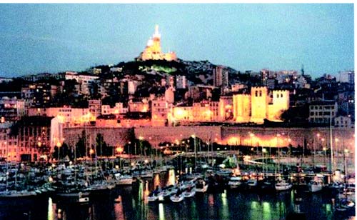 |
Port of Marseille |
Pilotage. – Pilotage is compulsory in the approaches to the port for vessels over 50m in length carrying hydrocarbons or dangerous substances, and for all other vessels over 70m in length.
Pilots generally board, for the N entrance, about 2 miles SW of the N head of Digue du Large, and for the S entrance, about 1 mile S of Ile de Chateau d’If.
Vessels should send an ETA 48 hours and 24 hours in advance or on leaving the previous port. (See Vessel Traffic Service System below.) Vessels should contact the pilot 1 hour before arrival on VHF channel 8.
Regulations. – A Mandatory Access Channel, the limits of which are shown on the chart, lies in Golfe de Marseille. This channel, the limits of which are shown on the chart, is entered 3 miles W of Ile de Planier and extends N and NE to the N end of the port.
All vessels over 1,600 grt, carrying hydrocarbons or dangerous substances, must report their entry into this channel and maintain a listening watch on VHF. For further information, see paragraph 9.1.
A Vessel Traffic Service System (VTS) has been established in the approaches to the port and is coordinated by The Traffic Management Centre (Call: Marseille Port Control) situated 1.3 miles NNE of the S entrance. It is mandatory for all commercial vessels navigating within the approaches.
Inbound vessels must send the following to the VTS Center:
- An ETA 48 hours in advance. The message should also include the name, call sign, length, beam, grt, draft, destination, last port of call, and type of vessel.
- An ETA at least 24 hours in advance. The message should also include length, draft, cargo, and nature and tonnage of any dangerous cargo. Vessels carrying hydrocarbons or dangerous cargo must report their entry into French territorial waters 6 hours in advance using the SURNAV message system.
All vessels must contact the VTS Center when in VHF range in order to receive mooring and berthing instructions.
All vessels must maintain listening watch on VHF channel 12 when within the approaches of the port.
Vessels within the area, which are not proceeding to the port and intending to cross the access channel, must contact the VTS center.
Anchorage. – Anchorage within Rade de Marseille, lying W of the center of Digue du Large, is not recommended. This roadstead is open to W winds and is not safe with E winds in winter, when gusts of wind are strong and frequent.
A designated anchorage area, the limits of which are shown on the chart, lies W of Digue du Large and close N of the S entrance.
Rade d’Endoume anchorage area, the limits of which are shown on the chart, lies centered 0.5 mile S of Pointe d’Endoume. It is situated between two prohibited anchorage areas and provides good anchorage in fair weather. Large vessels can anchor, in depths of 21 to 26m; small vessels can anchor, in depths of 11 to 13m.
The above anchorage areas have bottoms of mostly sand and weed, but several rocky patches have been reported to lie within them.
Baie du Grande-Soufre, lying W of the causeway connecting Ile Ratonneau and Ile Pomegues, offers temporary shelter during N winds. Vessels can anchor here, in a depth of 20m.
Caution. – An obstruction lies close NW of the N end of Digue du Large and is marked by a lighted buoy.
Several wrecks lie in the approaches to the port and may best be seen on the chart.
Due to the existence of submarine cables, several prohibited anchoring areas lie in the approaches to the port and may best be seen on the chart.
Basins within Dique du Large may no longer be maintained by dredging and may have lesser depths than charted. Vessels intending to berth within Dique du Large should contact the port authorities for current information.
Seaplane activity may occur in Rade de Marseille.
A wreck is reported (2006) to lie in 16.2m, about, 0.3 mile W of Dique Nord-Ouest West Light.
9.26 Ile Jarros (Jaire) (43°12'N, 5°22'E) lies 1.5 miles SE of Cap Croisette. This island is 58m high and bare, and an islet, 33m high, lies close off its NW end. A rocky shoal, with a depth of 2.5m, lies about 0.2 mile SE of the SE end of the island.
Montagnes de la Saint Baume, 1,147m high, stands 16 miles ENE of Cap Croisette. It is flat-topped with a vertical W side and dominates this stretch of the coast.
Ile Caleseragne, lying 0.5 mile S of Ile Jarros, is 22m high and flat. A shoal, with a depth of 3.3m, lies about 0.3 mile S of the S extremity of the island and is marked by a beacon.
Ile Riou (43°10'N, 5°23'E), lying 3 miles SE of Cap Croisette, is bare and rises to a sharp peak, 190m high. This island is very prominent, especially when viewed from the E, and is surrounded by several islets and above-water rocks. A light is shown from a structure standing on an islet lying 0.3 mile SW of the E extremity of the island.
Caution. – Anchoring, fishing, and dredging are prohibited within an area, the limits of which are shown on the chart, lying close NE of Ile Riou and extending to Ile Caleseragne. Due to unlighted floating objects and a submerged wellhead, navigation within this area should be carried out with care.
9.27 Plateau des Chevres (43°12'N, 5°22'E), a shallow area of weed and rocks, fronts the coast 1.5 miles ESE of Cap Croisette. It has a least depth of 6.7m and extends 0.5 mile offshore towards Ile Jarros.
Mouillage de Four-a-Chaux, entered close E of Plateau de Chevres, provides anchorage, in depths of 10 to 13m, weed. This bight affords good shelter from N and NW winds, but is open to the E.
Bec Sormiou, located 4 miles E of Cap Croisette, is a low, bare, and light-colored point.
Cap Morgiou, located 1 mile E of Bec Sormiou, is formed by a cliff and surmounted by two old batteries. La Grande Chandelle, a remarkable square mass of rock, stands 0.7 mile NE of the cape. It is 420m high and very prominent when seen from the E or W.
Mont Puget stands 5 miles E of Cap Croisette. It is 556m high and has prominent vertical escarpments.
Cassis (43°13'N, 5°32'E) (World Port Index No. 38820), a small harbor, lies at the head of Baie de Cassis, 7 miles ENE of Ile Riou. It is sheltered by a mole and has extensive facilities for yachts and small craft. A prominent castle stands 0.3 mile E of the harbor entrance and dominates the town. Anchorage can be obtained, in depths of 10 to 12m, sand and weed, in the bay. The holding ground is good, but the roadstead is open to S winds, which if strong, send in a heavy sea. Local knowledge is advised.
Port Miou, a narrow cove on the W side of the bay, offers shelter in depths 6 to 7m in all weather to vessels with local knowledge. A reef, awash at its N end and with a depth of 3.7m at its S end, lies about 4 miles SSE of Port Miou. It is marked by a lighted beacon, 23m high.
Caution. – A submarine pipeline extends 4 miles SSW from Port Miou and an anchorage prohibited area lies in its vicinity.
9.28 Bec de L’Aigle (43°10'N, 5°36'E), located 4.5 miles SE of Cassis, is 155m high and is formed by bare yellowish cliffs which are perpendicular in their upper part. The stretch of coast, which extends up to 3 miles NW of this point, is high and composed of reddish cliffs. A signal station stands 1.8 miles NW of Bec de L’Aigle and surmounts the summit of these cliffs.
Ile Verte, 47m high, lies 0.5 mile E of Bec de L’Aigle. A rocky shoal, with a depth of 0.9m, lies close W of this island and is marked by a beacon.
Baie de la Ciotat is entered between Bec de L’Aigle and Pointe du Deffend, 4 miles ESE. La Ciotat lies in the W part of this bay and Port des Lecques lies in the NE part.
Port des Lecques, consisting of two basins, is protected by a breakwater. It has extensive facilities for small craft and yachts. Vessels with local knowledge can anchor, in a depth of 9m, close SE of the harbor.
Pointe du Deffend (43°09'N, 5°42'E) can be identified by its white cliffs, 29m high, which appear to be cut off from the higher land to the E.
Caution. – A cable, 2,000m in length, with positive buoyancy, is situated about 60 miles S of Bec de L’Aigle at a depth of 600m and is a danger to subsurface navigation.
Baie de la Moutte, bordered by prominent reddish cliffs, is entered between Pointe du Deffend and Pointe des Engraviers, 1.2 miles SE. Ile Rousse, 18m high, lies 0.2 mile SE of Pointe des Engraviers. A prohibited area, the limits of which are marked by bouys and shown on the chart, lies close SW of Port des Lecques.
A submarine pipeline extends about 0.8 mile seaward from a point on the shore, 1 mile NNW of Pointe du Deffend.
9.29 La Ciotat (43°10'N, 5°37'E), a small port, mainly consists of a large shipyard which is used for the construction of tankers. The port is closed to commercial operations.
Winds – Weather. – The climate is comparatively mild, but the area is subject to the cold NW winds of the Mistral which blow down suddenly and violently from the mountains.
Depths – Limitations. – In addition to the drydock and shipbuilding installation, the port has extensive facilities for fishing craft and yachts.
The large harbor basin has 1,610m of total quayage with depths of 1.3 to 7.6m alongside. Vessels up to 380m in length, 60m beam, and 7.5m draft can be accommodated.
The port no longer handles commercial cargo vessels.
Aspect. – The harbor can be identified by the prominent cranes and workshops of the shipyard situated on its S side.
The Chapelle de Notre Dame de la Garde stands 0.7 mile NW of Bec de L’Aigle and is prominent from seaward.
Pilotage. – Pilotage is compulsory. Private pilots are provided by the shipyard. The port may be contacted on VHF channel 12 or 16.
Anchorage. – The bay affords poor holding ground on a bottom of mud and weed, and vessels are liable to drag during strong winds. Anchorage should be taken within 0.3 mile of the shore in order to get as much shelter as possible from the land and to avoid the steep slope of the bottom which occurs farther offshore. A good berth lies about 0.3 mile NE of the harbor entrance. Good anchorage is also available, in a depth of 14m, in Rade de Ceyreste, about 0.7 mile NE of the harbor entrance.
9.30 Baie de Bandol (43°08'N, 5°46'E) lies 3 miles SE of Pointe du Deffend and is entered between Ile de Bandol and Pointe de la Cride, 1 mile SSE.
Ile de Bandol can be identified by its prominent reddish -colored rocks. It is connected to a peninsula close N by a bank which has depths of 0.2 to 2m. Chateau de Bandol stands on the outer end of the peninsula, which is 25m high and is conspicuous.
La Fourmigue, a rock, lies on a shoal about 0.2 mile E of the E extremity of Ile de Bandol. It is 1m high and marked by a beacon. Vessels should not attempt to pass between the beacon and the island.
A small yacht harbor, protected by two jetties, lies on the N side of Ile de Bandol at its E end.
Pointe de la Cride, the S entrance point of the bay, is low and pointed. An old battery stands on its extremity. A reef extends SW from the point and is marked at its seaward end by a beacon.
9.31 Bandol (43°08'N, 5°45'E) (World Port Index No. 38840), a small harbor, lies on the W side of Baie de Bandol and is protected by a breakwater. It has extensive facilities for small craft and yachts. The harbor can accommodate small vessels, with drafts up to 4m, but is liable to silt up.
A nine-arch viaduct stands 0.7 mile ENE of the harbor and is very prominent from seaward.
Several outfall pipelines extend from the shore in the approaches to the harbor and a patch of foul ground, consisting of sunken moorings, lies about 230m E of the entrance.
Port Sanary Sur Mer, a small harbor, lies on the N side of Baie de Sanary, 1.5 miles E of Pointe de la Cride. It is protected by two moles and mainly used by small craft and yachts.
Baie de Sanary affords good shelter against winds from the NW through NE to SE, but W or SW winds, if strong, send in a heavy sea. An outfall pipeline extends 0.7 mile SW from a point close W of the harbor. Its seaward end is marked by a buoy. Vessels can anchor, in depths of 10 to 12m, sand and weed, good holding ground, SSW of the harbor entrance.
Port de la Couduriere, a small harbor, lies 1.2 miles SSE of Port Sanary Sur Mer and is protected by two moles. An obstruction is reported to lie about 0.2 mile WNW of the entrance which is 64m wide. The harbor is used by small craft and yachts.
Caution. – Due to the presence of mines, an anchoring, diving, and fishing prohibited area, the limits of which are shown on the chart, lies centered 1 mile SSW of Pointe de la Cride.
9.32 Port du Brusc (43°05'N, 5°48'E), a small harbor, lies 1.3 miles SSW of Port de la Couduriere and is protected by a jetty and a small detached breakwater. It has an entrance 46m wide and is used by small craft and yachts.
Ile du Grand Gaou and Ile du Petit Gaou, two small islands, lie close to the mainland, 0.7 mile SW of Port du Brusc. From the vicinity of these two islands, a bank, on which lie several islands and dangers, extends about 2 miles WNW.
Ile du Grand Rouvean (43°05'N, 5°46'E) lies 1.5 miles W of Port du Brusc. It is surrounded by rocks and is the outermost island on the bank. A light is shown from a structure, 14m high, standing on the summit of this island.
Rochers des Magnons, a group of small islets and above-water rocks, lies 0.3 mile W of Ile du Grand Rouveau. Seches des Magnons, a chain of reefs, extends up to about 0.2 mile SW of Rocher des Magnons and is marked by a beacon.
Vessels should give these dangers a wide berth.
Ile des Embiez lies 1 mile W of Port le Brusc. The channel between this island and Ile du Grand Rouveau is obstructed by numerous rocks. Pointe de Cougousset, the S extremity of the island, is also the highest point of the island. It is 61m high and surmounted by a prominent tower. An old castle, with a prominent tower, stands in the center of the island. Pointe Saint Pierre, the N extremity of the island, is surmounted by an old battery.
Ile du Petit Rouveau, 14m high, lies close NW of Pointe Saint Pierre. A detached rocky patch, with a depth of 2.1m, lies about 0.3 mile N of this island and is marked by a beacon.
Ilot de la Tour Fondue, 40m high, lies close E of Ile des Embiez to which it is connected. A light is shown from a structure standing on the N point of this islet.
Port Saint Pierre (Port des Embiez), a small harbor, lies on the N side of Ile des Embiez and is entered via a channel marked by buoys and beacons. It has extensive facilities for yachts and small craft.
Rade de Brusc lies between Ile des Embiez and the bank fronting the coast between Port de la Couduriere and Port du Brusc. This roadstead offers anchorage which is sheltered from winds from E through S to WSW. However, the holding ground is not good, especially in the N part where the bottom is formed by fine sand. A good anchorage berth lies in depths of 11 to 13m, with the N extremity of Ile du Grand Rouveau in line with Pointe Sainte-Pierre, N extremity of Ile des Embiez.
Caution. – Due to the existence of submarine cables, an anchoring, fishing, and diving prohibited area, the limits of which are shown on the chart, lies between the S end of Ile des Embiez and the mainland and extends 1.5 miles S. This area is used frequently by warships proceeding at high speed.
An islet, 9m high, lies close to the coast, 0.5 mile ESE of Ile du Grand Gaou. A light is shown from a structure standing on this islet when vessels are exercising in the vicinity. It has been reported that when this light is shown, navigation is prohibited N of 43°00'N, between the meridians of Ile du Grand Rouveau and Cap Sicie, due to naval gunnery practice.
9.33 Cap Sicie (43°03'N, 5°52'E), located 3.5 miles ESE of Ile des Embiez, is a dark headland which rises to two small peaks with a saddle between them. The prominent ruins of an old signal station stand on the E peak. The conspicuous chapel of Notre-Dame-de-la-Garde, with a pylon close W, stands on the W peak. A light is shown from a structure, 3m high, standing at the foot of the cape.
A rocky patch, with a depth of 4.5m, lies about 0.2 mile SE of the cape. Deux Freres, two dark and rugged rocks, lie 0.5 mile ENE of the cape. The N rock is 20m high and the S rock is 15m high ; both are very conspicuous.
Caution. – A submerged ordnance area, the limits of which are shown on the chart, lies 8 miles S of Cape Sicie.
Approaches to Toulon
9.34 Presqu’ile de Saint Mandrier (43°05'N, 5°56'E), located 3 miles NE of Cap Sicie, is a peninsula which extends 2.5 miles E from the coast. It is joined to the mainland by a low neck of land on which stands a large and prominent hotel. The buildings of the city of Toulon can be seen across this low neck from seaward.
Port de Sainte Elme, a small and shallow harbor, lies on the SE side of this low neck of land. It is protected by two moles and used by small craft.
Cap Cepet (43°04'N, 5°57'E) is the SE extremity of the Presqu’ile de Saint Mandrier. A light is shown from a structure, 15m high, standing on the cape. A prominent pylon, 22m high, stands close W of the light.
A signal station is situated at the fort, which stands 0.7 mile NNW of Cap Cepet.
Two lighted buoys are moored 0.7 mile S and SSE, respectively, from the light structure.
Pointe de Carqueirane (43°05'N, 6°01'E) is located on the E side of the approach to the port, 3.5 miles ENE of Cap Cepet. This point lies on the N side of the outer roadstead and can easily be recognized by its prominent red cliffs.
Golfe de Giens (43°04'N, 6°06'E) is entered between Pointe de Carqueiranne and Pointe Escampobariou, 4.7 miles SE. Pointe Escampobariou is the SW extremity of Presqu’ile de Giens, a peninsula, the W side of which is 118m high and sur-mounted by a tower.
The E side of this gulf is bordered by a low and flat isthmus which connects Presqu’ile de Giens to the mainland. The shore of the isthmus is fronted by shoal water which extends up to 0.5 mile seaward.
The N side of this gulf is moderately high. La Colle Noire, 294m high, Mont Paradis, 299m high, and Mont des Oiseaux, 306m high, stand 1.5 miles ENE, 2.7 miles NE, and 3.7 miles ENE, respectively, of Pointe de Carqueirane.
Port les Salettes, a small harbor, lies on the N shore of the gulf, 2.7 miles E of Pointe de Carqueirane. It is formed by two jetties and is used by yachts and small craft. Hospital San Salvador, a large and prominent building, stands 1.5 miles E of the harbor.
Les Fourmigues, consisting of two rocks, lies 1.5 miles NW of Pointe Escampobariou. The highest rock is 14m high and prominent.
Several small islets lie on a rocky bank which extends 0.5 mile W from the NW extremity of Presqu’ile de Giens and fronts the S shore of the gulf.
9.35 Grande Rade (43°06'N, 5°57'E), the outer roadstead of the port, is entered between Cap Cepet and Pointe de Carqueirane. The SW side of this roadstead is formed by the NE side of Presqu’ile de Saint Mandrier.
The N shore of Presqu’ile de Saint Mandrier is fronted by naval installations. These include several small craft basins and areas which have been dredged to depths of 4.5 to 7.5m.
Pointe Sainte Marguerite, located 1.7 miles NW of Pointe de Carqueirane, is formed by a steep, grey cliff which rises to a height of 65m.
Cap Brun, located 1 mile W of Pointe Sainte Marguerite, is surmounted by a prominent fort.
Port de Saint Louis du Mourillon, a small harbor, lies 1.5 miles W of Cap Brun. It is protected by a breakwater and used by yachts and fishing craft.
Presqu’ile du Mourillon extends 0.5 mile W from Port de Saint Louis du Mourillon to its SW extremity, which is surmounted by Fort de la Grosse Tour. A prominent seven-storied tower building stands 0.6 mile NE of the fort.
Grande Jetee, a main breakwater, extends 0.7 mile S from the SW extremity of Presqu’ile du Mourillon and forms the W side of Grande Rade. There is a gap in this breakwater, 45m wide, situated 135m S of the root.
Grande Pass, the principal entrance to the port, leads between the S end of Grande Jetee and the N side of Presqu’ile de Saint Mandrier.
Anchorage. – Golfe de Giens offers shelter during winds from the N through E to S. It is open to W winds, but the bottom consists of mud and weed and is a good holding ground. Vessels may anchor in the NE part of this gulf, clear of most of the obstructions and prohibited areas.
Caution. – Due to the existence of submarine cables, an anchoring and fishing prohibited area, the limits of which are shown on the chart, extends S from the vicinity of Port de Sainte Elme.
An outfall pipeline extends 0.5 mile SSE from a point lying close NE of the Cape Cepet.
A prohibited area, the limits of which are shown on the chart, fronts the shore of the NE side of Presqu’ile de Saint Mandrier and extends up to 250m seaward in places.
A prohibited area, the limits of which are shown on the chart, lies centered 0.6 mile NE of Cap Cepet. Several mooring buoys and obstructions lie within this area.
An obstruction, with a depth of 6m, lies about 0.2 mile ENE of Cap Cepet and several mooring buoys are situated in this vicinity.
Anchoring, fishing, and diving are prohibited within several areas, the limits of which are shown on the chart, lying within Golfe de Giens. Navigation is prohibited within a circular area, 400m in diameter, lying 0.3 mile N of the S shore of the gulf. An outfall pipeline extends 0.7 mile WSW from the NE shore of the gulf.
An outfall pipeline extends 1 mile SSW from a point on the shore, 0.2 mile E of Point Sainte Marguerite. A prohibited area, the limits of which are shown on the chart, is centered at the seaward end of this pipeline and is marked by a lighted buoy.
Several sonar target obstructions lie close S of Pointe de Carqueirane and may best be seen on the chart.
World Port Index No. 38870
9.36 Toulon has the largest and best natural harbor on this coast. It is the largest French military port on the Mediterranean coast of France. The port consists of a large outer roadstead and a spacious inner harbor, protected by an extensive breakwater. The principal facilities of the naval base and the commercial port occupy the entire N side of the inner harbor. Minor naval and commercial installations are scattered elsewhere about the port area.
Port of Toulon Home Page http://www.var.equipement.gouv.fr
Winds – Weather. – The prevailing winds are from the NW (Mistral) and W. These winds may reach a velocity of Force 11. Winds from the E and SE, which are less frequent, are generally accompanied by rain squalls, but do not exceed a velocity of Force 9. Winds from other directions are even less frequent and less strong. The presence of clouds over Mont Coudon and Cap Sicie is a sign of rain.
Tides – Currents. – The tides are almost negligible, having a range of 0.2m at springs.
Strong winds blowing from one direction for a prolonged period may affect the depths in the harbor, but not to any substantial degree.
The currents are weak and irregular and generally follow the direction of the wind.
Depths – Limitations. – Grande Rade, the outer roadstead, is deep, clear, and imposes no limitation on the size of vessel which can enter.
Petite Rade, the inner roadstead, is sheltered by Grande Jetee. Its N shore is occupied by the naval port which has berths with depths up to 10m alongside and includes extensive repair facilities and drydocks. It has been reported (2001) that the water depth in this basin is 2 to 3m deeper than charted.
The main commercial facilities at the NE side of the harbor include Fournel Quay, 345m long, with a depth of 9.5m alongside; Quay Est, 170m long, with a depth of 8.2m alongside; and Minerve Quay, 128m long, with a depth of 8.0m alongside. Minerve Quay can accommodate vessels up to 170m long, with a draft of 8m.
Additional commercial facilities are situated at La Seyne-Bregaillon, at the NW side of the harbor. These include two cargo berths, each 215m long, with a depth of 9.5m alongside.
There are facilities for general cargo, container, bulk, and roro vessels. Generally, vessels up to 250m in length and 8.8m draft can be accommodated. It was reported that vessels up to 340m in length have entered the harbor.
An oil terminal, consisting of a jetty extending for 520m parallel with the shore, is situated in the S part of the harbor. The berths can accommodate vessels up to 198m in length and have dredged depths of 10m alongside. This jetty is mainly used by naval vessels, but commercial tanker vessels can be accommodated with permission.
A yacht marina is situated on the W side of this inner harbor and a fishing craft basin is situated in the NE part. Aspect. – Pointe de Balaguier, marked by an old fort with a round tower and a flagstaff, lies in the roadstead to Toulon.
On approaching the coast, prominent landmarks include Six Fours, 210m high and conical, standing 4 miles WSW of Toulon; Mont Faron, 585m high and almost entirely wooded, standing 2 miles NNE of Toulon; Mont Coudon, 700m high with a vertical E side, standing 4 miles NE of Toulon; and Mont Caume, 801m high with a rounded peak, standing 3.5 miles N of Toulon.
 |
Pointe de Balaguier |
For additional landmarks, see Approaches to Toulon beginning in paragraph 9.34.
Lighted buoys are moored about 1.5 miles NNE, 1.1 miles NNE, and 0.8 mile NE of Cap Cepet. A buoy is moored about 0.8 mile ENE of the head of Grande Jetee.
Pilotage. – Pilotage is compulsory for all vessels of 45m in length and over.
Inbound vessels should send a request for pilotage to the harbormaster or to the Cap Cepet signal station at least 1 hour before their ETA in the outer roadstead stating vessel name, call sign, vessel type, length, and draft. Vessels should also send an amendment if their ETA is changed by over 30 minutes.
Pilots may be contacted on VHF channel 12, or 16 and generally board about 1 mile E of Grand Pass, the main entrance to the inner roadstead.
When vessels are proceeding to a military installation or are using a French naval tug, it is reported that a French Navy pilot will take the place of the civilian pilot at the harbor entrance.
Regulations. – A Mandatory Access Channel, the limits of which are shown on the chart, lies in the approaches to the port. This channel, which is entered 13 miles SSE of Cap Cepet, leads NNW until E of Presqu’ile de Saint Mandrier, and then WNW to the vicinity of the harbor entrance. Inbound vessels should keep to the starboard side of this access channel and pass N of the lighted buoy, which is moored about 1.1 miles NNE of Cap Cepet.
All vessels over 1,600 grt, carrying hydrocarbons or dangerous substances, must report their entry into this channel and maintain a listening watch on VHF. For further information, see paragraph 9.1.
All vessels over 1,600 grt, carrying hydrocarbons or dangerous substances, must send an ETA 48 hours in advance. The message should also include name, call sign, nationality, length, beam, draft, and type and quantity of cargo.
All other vessels must send an ETA 24 hours in advance. The message should also include name, call sign, nationality, length, beam, and draft.
All vessels over 30m in length should contact the signal station by VHF before entering Grande Rade, the outer roadstead, and should keep a continuous listening watch.
A speed limit of 12 knots is in force within Petite Rade, the inner roadstead.
A number of mooring buoys are situated within the several arms of the inner harbor, but they are primarily for use by French naval vessels, and merchant vessels are not permitted to secure to any of them without first having obtained permission from the port authorities.
Vessels are prohibited from anchoring within 250m of any mooring buoy and within 50m of any military establishment, pier, quay, or jetty.
Anchorage. – Grande Rade offers good natural shelter from all winds except those from the S and SE. Anchorage may be obtained in Grande Rade, except in the prohibited areas which are indicated on the chart.
Anchorage is prohibited in the inner harbor, except within a triangular-shaped anchorage area shown on the chart and situated in the N part.
Caution. – The head of Grande Jetee should be given a berth of at least 25m.
Banc de l’Ane, with depths of less than 11m, fronts the S part of the E side of Petite Rade and is marked by lighted buoys.
Several submarine cables and submarine pipelines cross the entrance to Petite Rade and may be best seen on the chart.
Several prohibited anchoring and fishing areas, the limits of which are shown on the chart, lie within the inner part of the harbor.
Toulon to Golfe de Saint-Tropez
9.37 Giens (43°02'N, 6°08'E) stands at the center of Presqu’ile de Giens, 1.5 miles ENE of Pointe Escampobariou. This village is very prominent from seaward.
Port du Niel, a small harbor, lies on the NW side of a small bay, close S of the village. It is protected by a jetty and used by small craft. Anchorage can be obtained by small vessels, in depths of 10 to 13m, within the bay.
Ponte de l’Esterel, the E extremity of Presqu’ile de Giens, is formed by a low, rocky, and tree covered promontory. A rock, 8m high, lies close off this cape.
Pointe de la Tour Fondue, located 0.7 mile WSW of Cap de l’Esterel, is a projecting point surmounted by an old fort. Port de la Tour Fondue, a small harbor, lies close NNE of the point and is used mainly by ferry boats serving Iles d’Hyeres.
Ile du Grand Ribaud (43°01'N, 6°09'E), 51m high, lies 0.7 mile SW of Pointe de la Tour Fondue. Its summit is surmounted by a prominent chateau. A light is shown from a structure, 14m high, standing on the S extremity of the island.
An islet, 18m high, lies midway between the island and the mainland coast. A rock, 6m high, lies close N of this islet.
Caution. – Due to the existence of submarine cables, an anchoring and fishing prohibited area, the limits of which are shown on the chart, lies E of Ile du Grand Ribaud and extends SE to Ile de Porquerolles.
9.38 Iles d’Hyeres (43°00'N, 6°23'E), a chain of four islands, extends up to 16 miles E of Ponte de l’Esterel. It consists of Ile de Porquerolles, Ile de Bagaud, Ile de Port Cros, and Ile du Levant.
Ile de Porquerolles (43°00'N, 6°12'E) lies centered 3 miles SE of Ponte de l’Esterel. The summit of the island, located 1 mile from its E end, is 142m high and surmounted by a signal station.
Cap d’Armes, the S extremity of the island, is located in the middle of the cliffy S coast. A light is shown from a structure, 16m high, standing on this cape. A radiobeacon is located at the light. A prominent mast stands 1 mile NE of the light.
An islet lies close N of the NW extremity of Ile de Porquerolles and a fort is situated on its N part. A shoal extends up to 0.3 mile N of this islet and is marked by a lighted beacon. A dangerous wreck lies about 0.2 mile NE of the beacon.
Anchorage can be obtained by vessels, with local knowledge, in a depth of 7m, weed, good holding ground, within a bay bounded on its W side by the islet and by the shoal extending to the N.
Port de Porquerolles, a small harbor, lies centered on the N coast of the island. It is protected from the N by a jetty and used by small craft. Small vessels, with local knowledge, may anchor, in a depth of 10m, about 0.3 mile NNE of the harbor jetty.
Several above-water rocks lie up to about 0.3 mile N of the NE extremity of the island, and two rocky islets lie close ESE and 0.3 mile ESE, respectively, of the SE extremity of the island.
9.39 Ile de Bagaud (43°01'N, 6°22'E) lies 5 miles E of the E extremity of Ile de Porquerolles. This island is 59m high, rocky, and is topped with thick trees.
Ile de Port Cros (43°00'N, 6°24'E), lies close E of Ile de Bagaud, is mainly wooded and is the highest island of the chain. Its summit, 207m high, is surmounted by a building, with two white cupolas, which are visible from a considerable distance.
An islet, 63m high, lie 0.2 mile S of the S extremity of the island.
Ile du Levant (43°02'N, 6°28'E), 130m high, lies centered 2.5 miles NE of the E end of Ile de Port Cros and is tree covered. A light is shown from a structure, 7m high, standing on Pointe du Titan, the SE extremity of the island. A peak, 99m high, stands 0.3 mile WNW of the light and is surmounted by a disused signal station.
A small above-water rock lies close ENE of Pointe du Titan. A rock, with a depth of 1.4m, lies about 1 mile ENE of the point and is marked by a beacon.
Caution. – Ile de Bagaud and Ile de Port Cros form a national park. Navigation, anchoring, and fishing are prohibited within 600m of the coastlines. Landing on Ile de Bagaud is prohibited. A prominent tower stands in the center and the prominent ruins of a fort are situated at the W end of the island.
Several mooring buoys and targets are moored close offshore around Ile du Levant.
Prohibited areas, the limits of which are shown on the chart, lie SW of Pointe du Titan (Ile du Levant) and extend up to 2 miles from the coast. These areas, which are used by French naval vessels, are not in force between July 1 and August 31. Vessels are prohibited from approaching within 200m of the coast of the island, except at the W end.
Anchoring and fishing prohibited areas, the limits of which are shown on the chart, extend up to 11 miles seaward from the S side of Ile du Levant and up to 2 miles seaward from the N side of the island.
Several gunnery and bombing ranges are situated in the vicinity of Ile du Levant. For further information, see Pub. 140, Sailing Directions (Planning Guide) North Atlantic Ocean, Baltic Sea, North Sea, and the Mediterranean Sea.
9.40 Rade d’Hyeres (43°05'N, 6°14'E) is entered between Cap de l’Esterel and Cap Benat, 9 miles ENE. This bay is sheltered by Iles d’Hyeres. Its NW shore is dominated by a range of hills, the S of which is surmounted by the conspicuous chapel of Notre Dame d’Hyeres.
Port d’Hyeres-Plage, a small harbor, lies 3 miles NNW of Ponte de l’Esterel. It is protected by breakwaters and is used by yachts, small naval craft, and ferries plying to Iles d’Hyeres. Anchorage may be taken, in a depth of 15m, about 0.7 mile from the harbor.
The town of Hyeres stands 2.5 miles NW of the harbor and is built in the form of an amphitheater at the foot of a black mountain. Le Fenouillet, 291m high, stands 1.5 miles NW of the town and has a conspicuous rock on its summit.
Port d’Ayguarde-Ceinturon, a small yacht harbor, lies 1.2 miles NE of Port d’Hyeres-Plage and is subject to silting.
Berrian-Plage, another small yacht harbor, lies 0.7 mile NE of Port d’Ayguarde-Ceinturon and a conspicuous building stands close E of it.
Caution. – Anchorage is prohibited within an area, the limits of which are shown on the chart, which extends 2 miles SE from a point on the shore, close N of Port d’Hyeres-Plage.
9.41 Port Pothuau (43°07'N, 6°12'E) (World Port Index No. 38890) fronts the town of Les Salins d’Hyeres and is protected by two jetties. This small harbor has an entrance, 60m wide, and can accommodate small vessels with drafts up to 4m. A quay, situated along the E jetty, and a slip, in the NE angle of the harbor, are reserved for the use of the French naval craft. The W side of the harbor is used by fishing and pleasure craft.
Port de Miramar, a small and shallow yacht harbor, lies 2 miles E of Port Pothuau.
Several mooring buoys are situated along the coast and within the roadsteads lying between Berrian-Plage and Port de Miramar.
A factory stands at Bormettes on the N shore of the bay, 6.5 miles NE of Ponte de l’Esterel. It is conspicuous and lighted at night. During the day, it may be identified by two tanks which are situated in the vicinity. A range of hills approaches the coast just E of this factory.
Pointe de Leoube, located 1 mile ESE of Bormettes, is faced with a small but prominent white cliff and is fronted by an islet.
Batterie des Maures, an artificial islet, lies 0.2 mile NW of Pointe de Leoube. It is prominent and surmounted by a discontinued light structure.
Cap de Bregancon (43°06'N, 6°19'E), 52m high, is located 1.7 miles ESE of Pointe de Leoube. This cape is the SW extremity of a rocky islet which is surmounted by a fort and connected to the mainland by a bridge. Chateau de Bregancon, a conspicuous building with turrets, is situated 1.5 miles NNW of the cape.
A small craft harbor, enclosed by two jetties, lies on the W side of a point, 0.5 mile E of the cape.
9.42 Cap Benat (43°05'N, 6°22'E), 185m high, is formed by the SE extremity of a large, rounded, and rugged hill. It is surmounted by an old signal station and a prominent television tower. A rock, 6m high, lies close E of the cape and is marked by a beacon. A small yacht basin is situated on the N side of the cape.
Pointe de Gouron (Cap Blanc), so called from the color of its rocks, which can be identified from some distance seaward, is located 0.3 mile SW of Cap Benat.
Cap Benat Light is shown from a structure, 16m high, standing near the extremity of Pointe de Gouron.
An obstruction, in the form of a submerged buoy with a depth of 20m, lies about 2.3 miles S of Cap Benat.
Pointe de l’Esquillette, located 0.7 mile N of Cap Benat, is fronted by a rocky spit which extends up to 0.3 mile E.
Bormes les Mimosas (La Faviere), a yacht harbor protected by a breakwater, lies 1.2 miles N of Pointe de l’Esquillette.
La Fourmigue, a rock, lies 2 miles NE of Cap Benat. It is 6m high, surrounded by submerged rocks, and is marked by a lighted beacon.
Caution. – Due to the existence of submarine cables, an anchorage prohibited area extends SE from the shore close N of Bormes les Mimosas harbor.
A measured distance is situated between Cap Benat and Cap Negre and is indicated by beacons.
9.43 Le Lavandou (43°08'N, 6°22'E), a small harbor, is protected by a jetty and a mole, and has depths of 1 to 4m. The original basin is used by small craft. Anchoring is prohibited within this basin on account of mooring chains lying on the bottom.
Quays at the W ends of the mole and the breakwater are reserved for the use of local ferries. An extensive yacht basin, protected by a curved breakwater, lies close SE of the original basin. Anchorage may be obtained, in depths of 15 to 20m, muddy sand, good holding ground, about 0.2 mile SE of the harbor.
Cap Negre (43°09'N, 6°27'E), a dark promontory, is located 4.2 miles NE of Cap Benat. This cape terminates in steep cliffs and is surmounted by a prominent house with two towers, which when seen from E, resembles a signal station. A beacon, which is used in connection with a measured distance, stands near the extremity of the cape. Another beacon, having the same use, is situated 0.8 mile NNW of the cape. Anchorage can be obtained, in a depth of 11m, within a small bay lying 1 mile W of the cape.
Pointe du Dattier is located 3 miles ENE of Cap Negre. A prominent white house stands 0.2 mile NNW of the point, and beacons are situated close N and 1 mile NNW of the point.
Cap de Cavalaire, located 4.2 miles ENE of Cap Negre, is the S extremity of a promontory which rises to a height of 70m, close N of the cape. A prominent television mast stands on the cape.
Pointe de Cavalaire, 30m high, is located 0.5 mile NE of Cap de Cavalaire and surmounted by a prominent white wall, 3m high.
9.44 Baie de Cavalaire (43°10'N, 6°34'E) is surrounded by hills which slope gradually to its shores. It is entered between Cap de Cavalaire and Cap Lardier, 3.7 miles E. Numerous villas are scattered along the head of the bay, and a conspicuous hotel is reported to stand close to the shore, 1 mile N of Pointe de Cavalaire.
Port de Cavalaire lies on the N side of Pointe de Cavalaire. It is formed by two jetties and has depths of 4 to 8m. This small harbor is used by small craft and has extensive facilities for yachts. The town, which is prominent, stands close NW of the harbor.
Cap Lardier may be identified by the grey color of its barren rocks. A wall, 4m high, stands on the cape and is prominent. A rock, with a depth of 7.1m, lies about 0.5 mile ESE of the cape.
Baie de Cavalaire offers shelter from the Mistral, but is untenable during winds from the E through S to SW. The bottom, consisting of mud and weed, is a good holding ground provided vessels do not anchor in too great a depth where the steep slope may cause dragging. Local knowledge is advisable.
Baie de Briande is entered between Cap Lardier and Cap Taillat, 1.2 miles NE. It offers shelter from the Mistral, but is exposed to all winds from seaward.
Cap Taillat, fronted by rocks, is the SE extremity of a peninsula which is 65m high and joined to the mainland by a low isthmus. A beacon stands on this cape.
Caution. – An outfall and associated prohibited area extend SE 0.7 mile from the coast from a point 1.0 mile NE of the breakwater at Port de Cavalaire.
9.45 Cap Camarat (43°12'N, 6°41'E), located 2.5 miles NE of Cap Taillat, terminates in a red point from which rocks, above-water and submerged, extend up to 0.7 mile E. A light is shown from a structure, 25m high, standing 0.2 mile W of the extremity of the cape. A signal station is situated close SE of the light.
Mont Paillas, 322m high, stands 3.5 miles WNW of the cape and is prominent. The village of Ramatuelle is situated 0.5 mile ESE of the summit of this hill and is conspicuous from seaward.
Anse de Pampelonne is entered between Cap Camarat and Cap du Pinet, 2.8 miles N. This bay is bordered by a low sandy beach on its W side. Several submerged rocks lie in places within 0.2 mile of the beach. An outfall pipeline extends 0.8 mile seaward in the S part of the bay.
The bay offers shelter from NW winds, but can not be used with E winds. The bottom consists of fine sand with patches of weed in places, which improves the holding ground. Anchorage can be obtained, in a depth of 14m, fine sand and weed, about midway between the entrance points.
La Nioulargo, a bank, lies 5 miles ENE of Cap Camarat and has a least depth of 52m.
Caution. – Diving is prohibited in an area, the limits of which are shown on the chart, lying in the vicinity of a historic wreck, 0.7 mile S of Cap Camarat.
9.46 Cap de Saint-Tropez (43°16'N, 6°42'E), the E extremity of a peninsula, is bordered E and NE by foul ground.
Basse du Verhuge lies about 2 miles ESE of the cape and has a depth of 13.7m. This shoal is dangerous in bad weather when the sea breaks violently over it.
Teste-de-Can, a group of three above-water rocks, lies 0.5 mile SE of the cape and is prominent. A rocky ledge extends up to about 1 mile NE of the cape and its seaward edge is marked by a lighted beacon. Basse du Nord-Est, a detached rocky patch, lies close ENE of the lighted beacon and has a least depth of 4m.
Le Saint Julien, a bank, lies 4 miles E of the cape and has depths of 53 to 70m.
Pointe de la Rabiou is located 1.2 miles NW of Cap de Saint-Tropez. The coast between is 30 to 60m high and prominent. A rocky ledge extends about 0.3 mile N from a point on the coast, 0.5 mile SE of Pointe de la Rabiou. It has depths of less than 5m, is awash at the seaward extremity, and is marked by a beacon.
A rocky shoal, with a least depth of 6.2m, lies about 0.5 mile N of Point de Rabiou and is marked by a beacon.
9.47 Golfe de Saint-Tropez (43°17'N, 6°39'E) is entered between Pointe de la Rabiou and Cap Sardinaux, 2 miles N, and extends for about 4 miles WSW.
Aspect. – On approaching the gulf, the following conspicuous landmarks can easily be identified:
- Chateau Borelly, which consists of a group of buildings surrounding a tower, standing 0.5 mile S of Pointe de la Rabiou.
- Saint-Tropez, standing on the S shore, which with its citadel and church tower, appears as a white mass.
- A water tower, 46m high, standing 0.7 mile SW of Saint-Tropez.
- Saint Maxime, standing on the N bank and containing several large hotels and a casino building.
- A distinctive tabular mountain standing in the background at the head of the gulf with a higher and conical peak close N of it.
Anchorage. – Anchorage can be obtained within the gulf in the following areas:
- Anse des Canebiers, a bay, lying 1 mile E of Saint-Tropez. It affords anchorage sheltered from S and SE winds. A good berth, in depths of 12 to 15m, lies about 0.3 mile N of the head of the bay.
- Off Sainte-Tropez, good anchorage can be found, in a depth of 15m, soft mud and good holding ground, about 0.2 mile WSW of harbor entrance.
- Off Pointe de la Pinede, good anchorage can be found, in depths of 12 to 15m, about 0.2 mile W of the point.
- Off Port Grimaud, anchorage may be taken close N of the harbor entrance, where the bottom is hard mud, but it is exposed to E winds.
- Off Sainte Maxime, anchorage can be taken off the harbor and sheltered from the Mistral, but it is exposed to E and SE winds. The bottom forms a good holding ground, but rocky banks extending SE of the harbor should be avoided.
Caution. – Several anchoring and fishing prohibited areas, the limits of which are shown on the chart, lie within the gulf.
Several shellfish farm areas lie close to the shore of the gulf and may best be seen on the chart.
9.48 Pointe de la Pinede (43°16'N, 6°38'E), located 0.5 mile WSW of Saint-Tropez, is low; a conspicuous large hotel stands 0.2 mile E of it.
Pointe de Bertaud, located 1.5 miles WSW of Saint-Tropez, lies at the SW corner of the gulf and a naval torpedo factory stands on it. Chateau Bertaud is situated close SW of the factory and a jetty extends NW from the shore adjacent to it. A light is shown from a structure standing at the head of this jetty.
The River La Giscle enters the gulf at the head, 0.5 mile NW of Pointe de Bertaud. Marines de Cogolin (Port de Cogolin) and Port Grimaud are located S and N, respectively, of the river mouth.
Marines de Cogolin is entered between two jetties. This small harbor can accommodate small craft, with drafts up to 4m, and has extensive facilities for yachts.
Port Grimaud is also entered between two jetties. This small harbor consists of a complex of waterways which form an extensive yacht basin. Small craft, with drafts up to 3.5m, can be accommodated. An outfall pipeline extends 0.2 mile E from a point, 0.2 mile N of the harbor entrance.
Sainte Maxime lies on the N side of the gulf, 3 miles NE of Port Grimaud. This small harbor lies on the E side of a bay and is protected by two breakwaters. Small craft up to 3.4m draft can be accommodated alongside and there are extensive facilities for yachts. Numerous prominent hotels stand close N of the harbor.
A rocky bank, with a least depth of 6m, extends about 0.2 mile SSE from the root of the S breakwater and should be avoided. A wreck, with a depth of 13m, lies close E of this rocky bank.
A rock lies about 0.3 mile from the shore, 0.5 mile E of the harbor. It dries 0.6m and lies near the edge of the coastal bank.
Cap Sardinaux (43°19'N, 6°40'E), the N entrance point of the gulf, is low but rises to a hill, 124m high, 1 mile W, which is surmounted by a conspicuous disused signal station.
An outfall pipeline extends 0.3 mile SSE from the S side of the point.
A rocky bank extends up to 0.7 mile E from the point and several above-water and shallow rocks lie on it. Les Sardinaux, a group of rocks, lies at the NE extremity of this bank and is marked by a beacon. Seche al’Huile, a shoal, lies at the SE extremity of this bank. It has a least depth of 3m and is marked by a prominent lighted beacon.
9.49 Saint-Tropez (43°16'N, 6°38'E) (World Port Index No. 38920), a small harbor, lies on the S side of the gulf and is used by small craft and yachts. The entrance, which is formed between a breakwater and an L-shaped mole, is 55m wide. A large flat mole fronts the W part of the harbor and divides it into two basins. The outer basin has extensive berths for yachts. The inner basin has depths of 6m in the center and 2.4 to 4m alongside the quays. Generally, the harbor is accessible to small vessels up to 70m in length and 4.9m draft.
The port may be contacted by VHF. Official pilots are not available, but can be obtained from Toulon with 12 hours advanced notice.
A hovercraft terminal is situated close SW of the harbor.
Caution. – Anchoring, dredging, and fishing prohibited areas, the limits of which are shown on the chart, extend up to 0.1 mile from the shore, close W of the harbor, and to the center of the gulf from close E of the harbor.
A wreck, with a least depth of 3m, lies 0.2 mile WSW of the harbor entrance.
Golfe de Saint-Tropez to Golfe de la Napoule
9.50 Baie de Bougnon (43°20'N, 6°41'E) is entered between Cap Sardinaux and Pointe des Issambres, 3 miles NE. This bay is bordered by numerous villas, and a large white building, which is very prominent from seaward, stands on its N shore.
A yacht marina, protected by two jetties, is situated at the head of the bay. The bay offers shelter from NW winds, but the anchorage is untenable with winds from seaward.
Golfe de Frejus (43°25'N, 6°46'E) is entered between Pointe des Issambres, which is low and wooded, and Cap du Dramont, 7 miles NE. Baie de Saint Raphael forms the NW corner of this gulf.
Between Pointe des Issambres and Pointe de Saint Aygulf, 2.7 miles NNE, the coast is slightly elevated and backed by hills which gradually rise to the W. The shore is fronted by a rocky bank which extends up to 0.1 mile seaward. A rock, with a least depth of 1.2m, lies near the edge of this bank, about 0.5 mile S of Point de Saint Aygulf. A dangerous wreck lies about 0.2 mile NE of this rock.
A small boat harbor is situated 0.7 mile N of Pointe des Issambres. An outfall pipeline extends up to 0.3 mile seaward from a point, 0.5 mile N of this boat harbor.
Bank du Mourrenegre, with depths of 68 to 84m, lies 2 miles ENE of Pointe des Issambres.
Between Pointe de Saint Aygulf and Saint Raphael, 2.5 miles NNE, the coast consists of a sandy beach backed by a low plain.
An outfall pipeline extends up to 0.5 mile seaward from a point, 0.5 mile N of Pointe de Saint Aygulf.
The River l’Argens flows into the gulf, 1 mile N of Pointe de Saint Aygulf.
A French naval air station is situated on the W side of Baie de Saint Raphael. The officers mess, a cream-colored prominent building, stands on the N side of the mouth of the River l’Argens. Hangars and other buildings are situated 0.5 mile NE of the mess. An aeronautical light is occasionally shown from a tower standing 0.5 mile NE of the river mouth.
A large hotel and a block of apartments stand along the shore between the naval air station and Saint Raphael and are very conspicuous.
The town of Frejus is situated 0.7 mile inland, 1.3 miles N of the river mouth. It can be recognized by the pointed belfry of the cathedral, which from seaward, stands out clearly against the background of mountains. Port Frejus, an extensive yacht marina, lies close NE of the N end of the air station.
Port de Santa Lucia lies 0.7 mile SE of Saint Raphael and consists of two extensive yacht basins, each protected by a breakwater. Craft up to 23m in length can be accommodated.
Anchorage. – Baie de Saint-Raphael, open S, is sheltered by the islets and rocks lying off Pointe des Lions. The bottom con-sists of thick, muddy clay and forms a good holding ground. Naval vessels generally anchor, in depths of 15 to 20m. Merchant vessels anchor, in depths of 12 to 16m, closer in.
Caution. – Several dangerous wrecks lie within Baie de Saint Raphael and may be seen on the chart.
An obstruction area, the limits of which are shown on the chart, lies off the mouth of the River l’Argens. A prohibited area, the limits of which are shown on the chart, lies adjacent to the shore, close N of the this obstruction area.
Due to the existence of submarine cables, an anchorage prohibited area, the limits of which are shown on the chart, extends up to 1.2 miles S from the vicinity of the S basin of Port de Santa Lucia.
9.51 Saint Raphael (43°25'N, 6°46'E) (World Port Index No. 38940), a small harbor, is protected by two broad jetties and is mostly used by small craft and yachts. The entrance, 60m wide, is subject to silting on its N side. Small vessels up to 91m in length and 4.5m draft can be accommodated. The harbor may be contacted on VHF channel 12 and unofficial pilots, or persons with local knowledge, are available. Vessels planning a visit should contact the port authorities by letter or telephone 8 days in advance, stating the vessel’s length, beam, draft, and ETA. The ETA should be confirmed 24 hours in advance. The harbormaster should be contacted by VHF 2 hours prior to arrival.
A church, with a large prominent dome, stands in the town, close to the harbor. Another church, with a prominent square clock tower, stands 0.2 mile NNE of the dome.
Caution. – Outfall pipelines extend up to 0.2 mile S from a point close E of the harbor, and up to 0.6 mile S from a point close W of the harbor.
The harbor is sometimes inaccessible in bad weather. Winds from the NW cause a choppy sea in the harbor and winds from the S send in much surf.
9.52 Pointe des Lions (43°25'N, 6°48'E) is located 0.3 mile E of the S basin at Port de Santa Lucia. It is low, red, rocky, and is surmounted by a prominent palace.
Le Lion de Mer lies 0.5 mile WSW of Pointe des Lions. This islet is 15m high, fringed with rocks, and is a reddish color. A light is shown from a structure, 10m high, standing on the SW part of the islet.
Le Lion de Terre, a reddish -colored islet, lies close W of Pointe des Lions and is connected to the mainland by a chain of rocks. The S and E sides of this islet are fringed with rocks.
Banc de Frejus and Banc Nouveau, with depths of 45 to 81m, are extensions of the coastal shore bank and lie 2 miles SE of Point des Lions.
Port de Boulouris, a small craft harbor, lies 1 mile ENE of Pointe des Lions. The prominent large buildings of a school stand on the coast, 0.7 mile ENE of this harbor.
Cap du Dramont (43°25'N, 6°51'E), the E entrance point of Golfe de Frejus, is formed by a steep and reddish cliff, 128m high, which is surmounted by a disused signal station. A large greyish quarry is situated 0.5 mile NW of the cape and is prominent.
A group of islets and rocks front the SE side of the cape. A small islet lies close SW of the cape, and a rock, with a depth of 1.8m, lies close SSW of it.
A small and shallow fishing boat harbor is situated 0.3 mile NW of the cape.
Ile d’Or lies 0.3 mile W of Cap du Dramont and is surmounted by a distinctive square tower. A spit, on which lies a rock awash, extends about 0.2 mile SW of this island.
Rade d’Agay (43°26'N, 6°52'E) is entered between Cap de Dramont and Pointe de la Baumette, 1 mile NE, and has a sandy beach at its head. Mornes Rouges d’Agay, 213 to 288m high, is a range of reddish hills which stand 0.5 mile inland at the head of the bay.
Caution. – An outfall pipeline extends 0.7 mile SE from a point on the shore, 0.8 mile N of Cap du Dramont.
9.53 Pointe de la Baumette is low and fronted by a bank with depths of less than 5m. A light is shown from a structure, 15m high, standing on the point. A conspicuous hotel stands close NE of the light and dominates the light structure. Chateau d’Agay and a white hotel, with a square tower, are situated on the E side of the bay. A large hotel, with a red roof, stands near the head of the bay.
Anchorage, sheltered from the Mistral, can be taken in the bay, but it is exposed to SE winds and a swell sometimes sets in from seaward. A good berth, in depths of 15 to 16m, lies about 0.2 mile W of the light on Pointe de la Baumette. Small vessels can anchor, in depths of 7 to 8m, at the head of the bay. The bottom consists of mud and weed, good holding ground.
Several buoys, used by pleasure craft, are moored in the inner part of the bay.
Pointe des Vieilles (43°26'N, 6°53'E) is located 1 mile ENE of Pointe de la Baumette. Numerous villas are scattered along the coast between these two points and a prominent hotel stands on Pointe des Vieilles. A conspicuous viaduct, clearly visible from seaward, is situated 0.5 mile N of the point.
A small and flat island, 8m high, lies on a rocky bank which extends up to 0.3 mile SSE of Pointe des Vieilles, and is surrounded by a group of rocks. A rock, 2m high, lies close S of the island; another rock, with a depth of 1.6m, lies about 0.5 mile S of Pointe des Vieilles and is marked by a lighted beacon. A wreck, with a depth of 22m, lies about 0.3 mile E of the beacon.
Caution. – A submerged target obstruction, with a depth of 100m, lies about 3 miles S of Pointe des Vieilles.
9.54 Cap Roux (43°27'N, 6°55'E) is located 2 miles NE of Pointe des Vieilles. It has a red summit, saddle-shaped with a rocky peak standing in the center of the dip. The cape terminates in a low point and the coast in the vicinity is fronted by rocks. Mont du Cap Roux, 457m high, stands 1 mile WNW of the cape and has a prominent bare summit. A prominent television mast, 58m high, stands on a summit, 1.8 miles NNW of the cape.
A conspicuous viaduct is situated at Trayas, a village, 0.7 mile N of the cape. A remarkable square rock stands in the center of another saddle, close above this village.
Cap de l’Esquillon (43°29'N, 6°57'E), 109m high, is located 2.3 miles NNE of Cap Roux. This point can be identified by its cliffs, its well-wooded slopes, and by a viaduct which engirdles it about halfway up.
A rock, 1m high, lies about 0.3 mile SE of the point and is marked by a lighted buoy.
Port de la Figueirette, a small craft harbor, lies 0.7 mile W of Pointe de l’Esquillon and is protected by a breakwater.
Pointe de la Galere is located 0.8 mile NNE of Pointe de l’Esquillon. A small craft harbor, protected by a breakwater, lies close N of the point. A lighted buoy, marking the approach to this harbor, is moored about 0.2 mile NE of the entrance.
Caution. – An outfall pipeline extends up to 0.5 mile SSE from a point on the shore, close W of Pointe de la Galere.
Pointe de l’Aiguille (43°30'N, 6°57'E), located 0.5 mile N of Pointe de la Galere, terminates in a pyramidal rock. A rocky patch, with a least depth of 1.8m, lies about 0.2 mile SE of the point.
The stretch of coast between Pointe de l’Esquillon and Pointe de l’Aiguille consists of cliffs which form the foot of a range of reddish hills.
9.55 Golfe de la Napoule is entered between Pointe de l’Aiguille and Cap de la Croisette, 4 miles ENE, from which a group of islands extends up to 2 miles S.
The W side of the gulf is bordered by the foothills of a range of mountains which terminate in Piton San Peyre. This hill, 131m high, stands 1.2 miles NW of Pointe de l’Aiguille and is surmounted by the ruins of a convent and a water tower.
The E side of the gulf is occupied by the town and port of Cannes, where the houses form a semicircle along the shore. Theoule-Sur-Mer, lying 0.5 mile W of Pointe de l’Aiguille, is a small craft harbor which is protected by two jetties.
Port de la Rague, lying 1 mile N of Theoule-Sur-Mer, is a small craft harbor which is protected by a breakwater. It has extensive facilities for yachts.
Port de Mandelieu-La Napoule lies 0.5 mile N of Port de la Rague and is protected by a breakwater. This small craft harbor, with extensive facilities for yachts, has depths of 2 to 10m and can accommodate vessels up to 50m in length.
Several prominent blocks of apartments stand between Port de Mandelieu-La Napoule and the mouth of the River Siagne, close N.
An extensive yacht marina is situated 0.5 mile within the river mouth. The river is spanned by several bridges with vertical clearances of 2.8m.
An outfall pipeline extends up to 0.8 mile SE from a point on the shore, 0.5 mile NE of the river mouth. A small boat harbor lies close SW of this point.
The conspicuous town of La Bocca fronts the coast, 1.7 miles NE of the river mouth. An airport and a conspicuous gas works are situated 1 mile W of the town. Several piers, one of which has a depth of 6m at the head, extend from the shore adjacent to the town.
A large and conspicuous villa is situated on the top of La Croix des Gardes, 160m high, which stands close N of La Bocca.
The coast between La Bocca and Cannes, 1.5 miles E, is covered with villas, gardens, and prominent hotels. A rock, with a depth of 6.7m, lies about 0.3 mile offshore, 0.5 mile ESE of La Bocca.
World Port Index No. 38960
9.56 Rade de Cannes is entered between a rounded point, located 1.1 miles E of La Bocca, and Cap de la Croisette, 1.2 miles SE.
This bay is almost exclusively used by pleasure craft and consists of the harbor of Cannes, locally called Cannes I, lying at the W side and the harbor of Cannes II, locally called Port Pierre Canto, lying at the E side.
A shallow yacht basin and a shallow fishing craft harbor lie close NNW of Cap de la Croisette.
Winds – Weather. – The prevailing winds are generally from between the W and N in winter. The NW Mistral is strong at times. In summer, winds from the E and W prevail, with occasional strong S winds.
A vessel anchored about 1.1 miles WNW of Pointe Bataignier reported (1998) a W current with a rate of 2 knots.
Tides – Currents. – The tides are negligible, the spring range being less than 0.3m.
Depths – Limitations. – The harbor of Cannes is protected by a breakwater, which extends SE from the rounded N entrance point of the bay, and by a jetty which extends S and SW from the shore. Rocks and shoals extend from the shore on the SE side of the jetty and are marked on their W side by a lighted beacon. Vessels entering the harbor must pass SW of this lighted beacon.
A berth alongside the W quay in the harbor is dredged to a depth of 6.7m. Small vessels up to 70m in length and 6.1m draft can be accommodated; however, it is reported (1989) that the berthing space is utilized by numerous yachts with permanent Med-moorings.
The harbor of Port Pierre Canto is protected by two jetties having quays on their inner sides. It has depths of 3 to 8m and extensive facilities for yachts.
Aspect. – The shore of the bay between the two harbors is fronted by numerous prominent buildings and hotels. The town of Cannes stands at the foot of the hills, which rise from the N shore of the Golfe de la Napoule.
A prominent casino stands on Cap de la Croisette. A hill, 245m high, stands 1.7 miles NNE of Cap de la Croisette and is surmounted by a prominent water tower; a large hotel stands halfway up this hill and is conspicuous. The conspicuous Observatoire du Grand Pin surmounts the summit of a hill, 270m high, standing 2 miles N of Cap de la Croisette and a prominent sanatorium is situated 0.5 mile N of it.
A prominent hotel stands on the rounded N entrance point of Rade de Cannes. A tower stands, with the prominent belfry of the cathedral a short distance N of it, close N of the hotel and W of the harbor.
A new light structure, 22m high, stands on the extremity of the breakwater at Cannes and is conspicuous.
Pilotage. – Pilotage is compulsory for commercial vessels of 50m loa and over and for pleasure craft 90m loa and over. The port can be contacted on VHF channel 8 or 16.
Requests for a pilot must be made 30 minutes in advance (summer) or 2.5 hours in advance (winter). Due to the large number of yachts entering the harbors, permission to moor and enter should be obtained in advance from the port captain.
The pilot boards up to 1 mile W of Iles de Lerins (43°30.5'N, 7°00.2'E).
Regulations. – Sailing vessels do not have the right of way over power-driven vessels within Rade de Cannes and Cannes harbor.
The speed of vessels within the harbor is restricted to 3 knots.
A regulated area, the limits of which are shown on the chart, lies between Cannes and the island lying S of Cap de la Croisette. The speed of vessels in this area is restricted to 10 knots and 5 knots when within 300m of the shore.
Anchorage. – Anchorage may be taken, in depths of 12 to 35m, mud and weed, within a designated area, the limits of which are shown on the chart, lying 0.5 mile S of Cannes.
Caution. – A submarine pipeline and several submarine cables extends SSE between Cap de la Croisette and the N shore of an island lying 0.7 mile S.
An outfall pipeline extends up to 0.5 mile S from the root of the outer breakwater at Cannes harbor; the seaward end is marked by a buoy.
Several rocky patches, with depths of 4 to 15m, lie in the W approach to Rade de Cannes and may best be seen on the chart. Rade de Cannes is generally very crowded with small craft and yachts.
9.57 Iles de Lerins (43°31'N, 7°03'E) lie on a rocky bank, with depths of less than 5m, which extends up to 2.5 miles S from Cap de la Croisette. They consist principally of Ile Sainte-Marguerite and Ile Saint-Honorat.
Ile Saint-Marquerite lies centered 1 mile SSE of Cap de la Croisette and is very wooded. A conspicuous citadel, in which there is a disused signal station, stands near the middle of the N coast of the island. A small shipyard is situated close W of this citadel.
The NW extremity of the island is surmounted by a ruined tower. It is fronted by a shoal, with depths of less than 2m, which extends up to 0.3 mile N and is marked by a lighted beacon. A shoal, with a depth of 8.6m, lies about 0.3 mile NW of the beacon and the sea breaks on it during S winds.
The E extremity of the island has the ruins of a battery standing close WSW of it. A low islet lies close E of this point and is connected to it by a ridge of rocks.
Ile Saint-Honorat lies centered 1.8 miles SSE of Cap de la Croisette. A conspicuous chateau stands on a projection on the S coast of the island. The belfry of an abbey, which emerges from the surrounding trees close N of the chateau, is prominent.
The E extremity of the island is surrounded by small islets and rocks which extend up to 0.3 mile from it. This point is surmounted by a prominent ruined chapel.
The rocky bank, on which these islands lie, extends 0.5 mile S of Ile Saint-Honorat and is marked at its S end by a lighted beacon.
Anchorage, sheltered from N and S winds, can be taken on a bottom of muddy sand and weed, good holding ground, between Ile Sainte-Marguerite and Ile Saint-Honorat. Vessels should anchor E or W of the rocky bank lying between these islands. There is also good anchorage for small vessels to the N of Ile Sainte-Marguerite and to the E of the citadel. With Mistral winds, a sheltered anchorage is available to the E of Cap de la Croisette, but care must be taken to avoid the dangers in this vicinity.
Caution. – Several submarine cables lie on the rocky bank and extend between the islands.
A speed limit of 5 knots is in force within the channel lying between the islands.
9.58 Golfe Juan (43°33'N, 7°06'E) is entered between Cap de la Croisette and Point de l’Ilette, 3.8 miles ENE. This gulf is sheltered from the SW by Iles de Lerins and from the S by shoals and is one of the best roadsteads along this part of the coast. In the approaches to the gulf, the currents are weak and are usually influenced by the wind.
From seaward, the gulf appears to be bounded to the N by a range of low hills. These hills form a buttress ending at Cap de la Croisette, on their W side, and separate Golfe Juan from Golfe de la Napoule.
A hovercraft terminal is situated on the SE side of Cap de la Croisette. The approach channel is marked by buoys and the arrival and departure of the hovercraft are indicated by a siren which sounds one long blast every ten seconds.
Port du Moure-Rouge, lying 0.5 mile NNE of Cap de la Croisette, is a small craft harbor which is protected by two jetties. A prominent seminary, formerly a hotel, stands halfway up a hill, 0.7 mile NE of the harbor.
The N side of the gulf is formed by a beach behind which stands numerous conspicuous houses, villas, and hotels.
Port de Golfe Juan, lying 2.5 miles NE of Cap de la Croisette, is a small craft harbor which is protected by two breakwaters and has extensive facilities for yachts. A light is shown from a structure, 16m high, standing 0.7 mile WNW of the harbor entrance. A high building situated close to the E breakwater is conspicuous.
Port Gallice lies on the E side of the gulf, 1.7 miles E of Port de Golfe Juan. This small craft harbor is protected by two breakwaters and has extensive facilities for yachts. The approach channel lies close SE of shoals, with a depth of 2m, and is marked by lighted buoys, buoys, and beacons. A small boat basin lies on the SE side of the harbor.
The village of Juan-les-Pins is situated close NNE of Port Gallice and has numerous high buildings lining the waterfront. A large white building standing close to the church, at the E side of the village, is very prominent. Also prominent is a moorish -type villa, with a white minaret, standing close to the beach, at the W end of the village.
La Garoupe (43°34'N, 7°08'E), located 0.7 mile E of Port Gallice, is the highest point of the Cap d’Antibes peninsula. It dominates the E shore of the gulf. A light is shown from a structure, 95m high, standing on this point.
A signal station and a prominent chapel are situated close NE and close SW, respectively, of the light.
Pointe de l’Ilette (43°33'N, 7°07'E) is the E entrance point of the gulf and the SW extremity of the Cap d’Antibes peninsula. A light is shown from a structure, 11m high, standing on the point.
Tour Graillon, a 20m high tower, stands 0.3 mile N of the light, with a prominent hotel situated close SE of it.
A rocky bank, with a least depth of 3.5m, lies about 0.3 mile S of Pointe de l’Ilette.
9.59 La Fourmigue (43°32'N, 7°06'E), a group of low and dark rocks, lies 1.7 miles WSW of Pointe de l’Ilette and is marked by a lighted beacon which stands on the highest rock.
Basses de la Fourmigue consists of several rocky patches with depths of 5 to 9m. These patches lie on a bank which extends up to 1 mile ENE of La Fourmigue. Le Secanion, with a least depth of 5m, is the farthest E of these patches. It lies 0.8 mile E of La Fourmigue and is marked by a buoy.
The main access to Golfe Juan is made through Passe de l’Ouest, which lies between Ile Sainte-Marguerite and La Fourmigue. Access can be made through Passe de l’Este, which lies between Le Secanion and the Cap d'Antibes peninsula.
The roadstead in the gulf is sheltered from NW winds. A considerable sea is raised by SSE winds, but it is not dangerous for well-moored vessels. Large vessels can anchor, in depths of 13 to 15m, about 0.8 mile NE of La Fourmigue. Small vessels can anchor farther N, in depths of 10 to 12m. Vessels can also obtain anchorage in Mouillage du Piton, sheltered from the E, but exposed to S winds. This roadstead, lying 0.5 mile NW of the Tour Graillon, has depths of 14 to 16m and a bottom of mostly soft mud and weed.
Caution. – Several submarine cables, which may best be seen on the chart, extend seaward from a point on the shore, 0.7 mile NNE of Cap de la Croisette.
Anchoring and fishing are prohibited in a nature reserve area lying 1.5 miles NE of Cap de la Croisette. This area is marked by buoys and may best be seen on the chart.
An outfall pipeline extends 1 mile SSE from the harbor entrance at Port de Golfe Juan and is marked by a buoy at its seaward end. Anchoring is prohibited in the vicinity of this pipeline.
9.60 Cap Gros (43°33'N, 7°09'E) is located on the E side of the Cap d’Antibes peninsula, 1.2 miles NE of Pointe de l’Ilette. A shoal, with a least depth of 4.6m, lies close E of this cape.
Anchorage can be taken, in depths of 18 to 20m, sand and weed, good holding ground, within Anse de La Garoupe, which is entered between Cap Gros and Pointe Bacon, 1 mile N.
Between the peninsula of Cap d’Antibes and the peninsula of Cap Ferrat, 11 miles NE, the Alpes Maritimes recede from the coast, which appears low from seaward.
Pointe Bacon is fronted by a rocky bank, with depths of less than 5m, which extends up to 0.3 mile NNE of it. A reef, partly above-water, lies on this bank. Rocks, with depths of 12m and 13m, lie about 0.2 mile ESE and 0.4 mile ENE, respectively, of the point.
Port de la Salis lies in the S corner of a bay, 0.5 mile W of Pointe Bacon. This small craft harbor is protected by two breakwaters. Numerous rocky patches and above-water rocks lie in the approaches to the harbor and may best be seen on the chart.
Caution. – An explosives dumping ground area, the limits of which are shown on the chart, lies centered 0.6 mile NE of Pointe Bacon.
An outfall pipeline extends up to 0.5 mile E from Pointe Bacon.
Submarine cables extends seaward from a point on the shore, close NW of Port de la Salis and can best be seen on the chart.
World Port Index No. 38980
9.61 Antibes (Port Vauban) is an ancient town standing on a promontory which separates the harbor from the small bay to the S. The harbor has extensive facilities for pleasure craft, yachts, and fishing boats.
Tides – Currents. – Tides are negligible in the area, but winds and other conditions may vary the level in the harbor somewhat.
Depths – Limitations. – The harbor is protected by an outer breakwater which extends NE and N from the NE corner of the town. It consists of an inner yacht basin, in the W part, a fishing boat basin, in the S part, and a small craft and pleasure craft basin, in the center. In addition, a commercial tanker berth, with a depth of 8m alongside, is situated on the inner side of the breakwater at the outer end. This berth is 40m long and can accommodate small vessels up to 3,000 tons.
Generally, yachts and pleasure craft up to 50m in length and 3.5m draft can be accommodated within the basins.
Aspect. – The town is surrounded by fortifications and flanked by two large square towers. Fort Carre surmounts the point on the N side of the harbor and is prominent.
A light is shown from a structure, 10m high, standing on the head of the outer breakwater.
 |
Antibes |
Pilotage. – The harbor may be contacted on VHF channel 9 or 16. Pilotage is not compulsory, but is available for the larger vessels.
Anchorage. – Vessels can anchor E or NE of the harbor entrance, but the bottom of fine sand is a poor holding ground and they are advised to anchor in Golfe Juan. Vessels can also anchor, in depths of 10 to 20m, E of the town.
9.62 Port Marina Baie des Anges (43°38'N, 7°08'E), a small craft harbor, lies 3 miles NNE of Antibes. It is protected by two breakwaters and has extensive facilities for yachts. The harbor is backed by large pyramidal blocks of apartments which are very conspicuous from seaward.
The shore between the harbor and Antibes is low and backed by a range of low hills which stand a short distance inland. Villeneuve-Loubert and Cagnes are villages standing on the slopes of these hills, 1.5 miles NNW and 2 miles NNE, respectively, of the harbor. Both villages are prominent from seaward and a high conspicuous tower is situated at Villeneuve-Loubert.
Caution. – An outfall pipeline extends 0.5 mile SE from a point on the shore, 1.5 miles NE of Port Marina Baie des Anges.
A submarine cable extends SE from a point on the shore, 1 mile NNE of Port Marina Baie des Anges.
9.63 Port de Saint Laurent du Var (43°39'N, 7°11'E), a small craft harbor, lies 2.3 miles NE of Port Marina Baie des Anges. It is protected by breakwaters and has extensive facilities for yachts. A boat basin lies 0.5 mile W of the harbor and is reported to be subject to silting.
The River Var flows into the NE part of Baie des Anges, 0.7 mile E of Port de Saint Laurent du Var. Its mouth may be identified by a large bridge, which crosses the river 0.5 mile within the entrance, and by three prominent chimneys which stand at a factory farther inland.
The coast projects on either side of the river mouth and the entrance is dangerous to approach at night.
Nice-Cote d’Azur Airport is situated close E of the river mouth and is conspicuous at night because of its numerous lights. The S part of the airport is built on reclaimed land. The control tower and some prominent suburban houses situated behind the runways may be seen from seaward.
The coast to the NE of the airport consists of a beach, backed by houses. A prominent belfry stands near the shore, 2.3 miles NE of the mouth of the River Var.
Caution. – A prohibited area, the limits of which are shown on the chart, surrounds the seaward sides of the airport. Areas, in which vessels with superstructure heights of 4m or more above sea level are prohibited, lie at the NE and SW sides of the airport and may best be seen on the chart.
World Port Index No. 38990
9.64 The city of Nice, standing 4 miles NE of the mouth of the River Var, is a world famous tourist and health resort.
Winds – Weather. – Winds from the S and SW are rare, but they sometimes blow in gusts with rain squalls and create a strong swell in the entrance channel.
Tides – Currents. – Tides are almost negligible, being within a range of about 0.3m.
The water level may vary as much as 0.3 to 0.6m with the wind. Rises of up to 1m have been observed with strong gusts from the E.
Depths – Limitations. – The harbor is divided into four basins. Bassin de Tour Rouge, the outer NE basin, has berths for small craft and yachts.
Bassin Lympia, the inner basin, has a depth of 6.5m and extensive facilities for small craft and yachts are situated at its E side. Quai Papacino, 140m long, lies at the W side of this basin and has a depth of 5.5m alongside.
Bassin Admirals, the central basin, has a depth of 7m. Quai Infernet, 215m long, lies at the SW side of this basin and has a depth of 7m alongside. Quai Ribotti, 90m long; Quai d’Entrecasteaux, 95m long; and Quai des Caboteurs, 95m long, also lie within this basin and have depths of 5.5m alongside.
Bassin du Commerce, the main outer basin, has a depth of 7m. Quai de Commerce, 245m long, with a depth of 7m alongside, and Quai Traverse du Commerce, 125m long, with a depth of 6.5m alongside, lie within this basin.
The harbor has facilities for automobile ferries and ro-ro vessels.
Vessels up to 170m long, with a draft of 7m, can be accommodated.
Aspect. – The promontory of Mont Boron overlooks the city from close E and rises to a summit, 220m high, 1 mile N of its seaward end. Fort de Mont Alban stands on the summit and is very prominent.
From the summit of Mont Boron, a range of high mountains backs the coast to the E as far as the Italian border.
An observatory, with a prominent cupola, stands on the summit of Mont Gros, which is 375m high and stands 1.5 miles N of Fort de Mont Alban.
The entrance to the harbor lies between Cap de Nice, the SW extremity of the Mont Boron promontory, and Le Chateau, a distinctive wooded hill, standing at the SE end of the city, 0.7 mile NW. The harbor is protected by a breakwater which extends SE from Le Chateau. A prominent light structure, 20m high, stands on the head of the breakwater.
Several high -rise buildings back the NE shore of the harbor and are very conspicuous from seaward.
Pilotage. – The pilotage area includes the port of Nice and Rade de Villefranche and extends up to 3 miles seaward of the harbor. Pilotage is compulsory within this area for vessels of 50m or more in length.
Pilots can be contacted on VHF channel 12 or 16 and generally board about 1 mile from the harbor entrance.
Pilots are also available here for other harbors along the coast as far as the Italian border.
Regulations. – Vessels should send an ETA 24 hours in advance through Grasse (TKM) and confirm it when within VHF range.
Anchorage. – Vessels are advised to anchor in Rade de Villefranche.
Caution. – A restricted area, the limits of which are shown on the chart, lies S of the harbor entrance and extends up to 1 mile seaward. Within the zone, vessels under sail and vessels under power of less than 20m in length can only transit to enter or depart the port or obtain or leave an anchorage. In addition, they must avoid the route taken by warships and power vessels of 50m or more in length.
The harbor entrance is reported to be very hard to distinguish from seaward, and vessels are advised to steer for the observatory on Mont Gros until the entrance can be identified.
9.65 Rade de Villefranche (43°42'N, 7°19'E) is entered between Pointe des Sans Culottes, the SE extremity of the Mont Boron promontory, and Pointe Malalongue, the SW extremity of Cap Ferrat, 1 mile SE.
The bay extends N for 1.5 miles and offers sheltered anchorage to vessels of any size. It is used by vessels that cannot enter Nice.
The W coast of the bay is dominated by the promontory of Mont Boron. The E coast is formed by the rugged and moderately-elevated promontory of Cap Ferrat.
Cap Ferrat Light is shown from a structure, 32m high, standing close N of Pointe Malalongue. A large hotel, very prominent from seaward, stands 0.2 mile E of the light. A prominent signal station surmounts the summit of Cap Ferrat, which is 138m high and stands 0.5 mile N of Point Malalongue.
Anse de l’Espalmador, at the E side of the bay, offers shelter from E winds.
Caution. – Within the bay, sailing vessels do not have the right of way over vessels under power.
Speed is limited to 5 knots within an area which extends 1 mile S from the head of the bay.
Anchoring, fishing, and diving prohibited areas, the limits of which are shown on the chart, lie in the vicinity of Pointe des Sans Cullottes; in the vicinity of the shore, close NNW of Pointe Malalongue; and SW of Cap Ferrat. They extend up to 1.5 miles seaward.
This bay may sometimes be used by sea planes fighting forest fires.
9.66 Villefranche (43°42'N, 7°19'E) (World Port Index No. 39000), consisting of two small harbors, lies at the NW side of the bay.
Depths – Limitations. – The N harbor is protected by a breakwater and is used by yachts. It is small and has depths of only 1m.
The S harbor is protected by a breakwater and has facilities for small craft. Vessels up to 60m in length and 4m draft can be accommodated.
Aspect. – The prominent town is built in the form of an amphitheater. The Citadel, a large structure with four bastions, is very conspicuous. It stands close S of the town between the two harbors.
Pilotage. – For further information, see Nice in paragraph 9.64.
Anchorage. – Vessels generally anchor on the W side of the bay from abreast the S harbor breakwater to abreast the N end of the town; the bottom is soft mud and weed.
Caution. – Several mooring buoys are situated in the bay and may be used by vessels up to 35,000 tons.
A prohibited anchorage area, the limits of which are shown on the chart, lies in the center of the bay, 0.3 mile E of the S harbor.
Rade de Villefranche to Monaco
9.67 Presqu’ile de Saint Hospice (43°41'N, 7°21'E), 40m high, is a peninsula which extends E from the center of the E side of the Cap Ferrat promontory. It is surmounted by a chapel and a conspicuous tower Pointe Saint Hospice, located 1.2 miles NE of the Cap Ferrat Light, is the E extremity of the peninsula.
Vessels, with local knowledge, can anchor off Anse de Scaletta, a small bay, lying 0.2 mile WNW of Pointe Saint Hospice. There are depths of 6 to 13m with a bottom of muddy sand and weed, good holding ground.
Port de Saint Jean Cap Ferrat, a small harbor, lies on the N side of the root of Presqu’ile de Saint Hospice. It is protected by a breakwater, which extends NNW, and can accommodate small craft and yachts with drafts up to 4m.
Beaulieu-sur-Mer is situated on the coast, 1.2 miles NNW of Pointe Saint Hospice. This town may be identified by several prominent buildings. Two harbors are situated in this vicinity. Port des Fourmis lies close S of the town and Port de Beaulieu lies close N of it.
Port des Fourmis is very small and shallow. It is formed by two breakwaters and is used by small fishing craft and yachts. A prominent white house stands on a point located close E of the harbor.
Port de Beaulieu is enclosed by a breakwater and its entrance is protected by a detached breakwater. This harbor has extensive facilities for small craft and yachts.
Caution. – An anchoring and fishing prohibited area, the limits of which are shown on the chart, lies 0.6 mile SE of Beaulieu and is marked by buoys.
The waters off Beaulieu may sometimes be used by sea planes fighting forest fires.
9.68 Cap Roux (43°43'N, 7°21'E) is located 0.7 mile NE of Beaulieu. Port de Silva Maris, a very small boat harbor, lies on the NE side of this cape.
Between Cap Roux and Cap d’Ail, 2.5 miles E, the coast is very high. Eze, a village with a prominent viaduct nearby, surmounts a hill which stands 0.8 mile NE of Cap Roux and is very conspicuous.
Cap d’Ail (43°43'N, 7°25'E) is formed by a low and bare plateau and is surmounted by the ruins of a battery. A rocky bank, with depths of less than 9m, extends up to 0.2 mile S from the cape.
Port de Cap d’Ail, a small harbor basin, lies on the SW side of the area of reclaimed land, 0.7 mile SW of the main harbor. It is protected by breakwaters and used by yachts.
La Tete de Chien, 550m high, is a distinctive rock standing 0.8 mile N of the cape.
Mont Agel, a flat and level mountain, stands 3.2 miles NNE of the cape. It is 1,148m high and surmounted by several radio masts and a prominent radar scanner. Another radio mast stands 0.5 mile NE of its summit.
World Port Index No. 39025
9.69 The Principality of Monaco consists of three towns and three harbor basins. Monaco, the capital, is built on a promontory which stands on the S side of the main harbor, 1 mile NE of Cap d’Ail. La Condamine, the commercial town, is situated close W of the main harbor and Monte Carlo, the residential town, is situated close N of it.
The International Hydrographic Organization has its offices in Monte Carlo.
Winds – Weather. – Strong E to SE winds cause a heavy sea in the harbor.
Depths – Limitations. – Port de Fontvielle, another harbor basin, lies on the N side of the area of reclaimed land and is bordered on the N side by the town of Monaco. It is protected by two breakwaters and is used by small craft and yachts. Craft up to 35m in length can be handled.
Port de la Condamine, the main harbor basin, lies N of the town of Monaco. It is entered between two breakwaters which form an entrance 100m wide at the surface and 80m wide at the bottom. Depths up to 22m lie in the outer part of this basin and the quays have depths of 4 to 8.5m alongside. Vessels up to 135m in length, 20m beam, and 7m draft can be accommodated. The harbor is mainly used by pleasure craft and there is very little commercial activity.
Aspect. – The Principality of Monaco can be easily identified from seaward by its numerous buildings. These buildings give it the appearance of a whitish patch on the coast, and enable vessels, approaching from the S, to identify this part of the coast although the nearby peaks may be covered by fog.
Conspicuous landmarks include the Sports Complex standing on the reclaimed land, close NE of Port Cap d’Ail; the Oceanographic Museum, a large white building, standing on the SE side of Monaco; and the Casino of Monte Carlo, with its green cupolas and two bell towers, standing close N of the main harbor.
An aeronautical light is occasionally shown from the heliport.
Pilotage. – Pilotage is compulsory for commercial vessels entering the port. Pilots should be requested 24 hours in advance through Monaco CRS or Grasse CRS. The pilot can be contacted on VHF channel 12 and boards 0.3 mile E of the port entrance.
Regulations. – Vessels should send their ETA to the harbor-master 48 hours in advance, stating the vessel’s name, dimensions, draft, flag, and duration of stay. The ETA should be confirmed 24 hours before arrival.
Anchorage. – Anchorage may be obtained E of the main harbor entrance, in a depth of 70m, or NE of the entrance, in a depth of 50m, outside the anchorage prohibited areas.
Caution. – Oceanographic data equipment lies moored 28 miles SE of Monaco along the seaward alignment of the French -Italian border. A restricted area, marked by two ODAS buoys, one of which is lighted, marks the instrumentation.
A prohibited zone, the limits of which are shown on the chart, lies adjacent to the shore between the outer breakwaters of Port Cap d’Ail and Port de Fontvielle. This zone is due to the establishment of a heliport on the reclaimed land lying between the two harbors.
A prohibited anchorage area, the limits of which are shown on the chart, extends E and S of Port de Fontvielle. An outfall pipeline extends 0.4 mile SE from a point on the shore, 0.2 mile NE of Port Cap d’Ail. The navigation of power boats is prohibited within a marine reserve area, the limits of which are shown on the chart, lying adjacent to the shore, 0.7 mile NE of the main harbor. Anchoring and fishing are also prohibited within this area.
An outfall pipeline extends 0.2 mile from the shore near the S end of this marine reserve area and anchoring in its vicinity is prohibited.
Entry prohibited areas, best seen on the chart, extend seaward from the breakwaters at Port de la Condamine. These areas mark works in progress (2002). The works are intended to extend the harbor E with two new breakwaters. This will create a new basin E of the existing entrance.
An anchorage prohibited area, shown on the chart, extends E from the entry prohibited areas. Two lighted mooring buoys are located at the SE limit of the area.
Monaco to Ruisseau Saint-Louis (French -ItalianBorder)
9.70 Pointe de la Vieille (43°45'N, 7°27'E) is located 1.2 miles NE of Monaco and is fronted by rocks.
Baie de Roquebrune is entered between Pointe de la Vieille and Cap Martin, 1.8 miles E, and the town of Roquebrune stands close N of its head. An old prominent fort stands in the town and a large rock, surmounted by a tower, overlooks the town.
Cap Martin terminates in a low point on which stands a large hotel. A disused signal station and a water tower are situated 0.2 mile NW of the hotel and rise above the olive and pine trees which cover the cape. During good weather, vessels can anchor, in depths of 10 to 20m, rock and weed, in the middle of the bay.
Caution. – An outfall pipeline extends 0.5 mile S from Cap Martin.
An anchoring and dredging prohibited area, the limits of which are shown on the chart, lies centered 0.3 mile E of Pointe de la Vieille and is marked by a buoy.
9.71 Menton (43°47'N, 7°31'E), a small harbor, lies 2 miles NE of Cap Martin. It is protected by two jetties and is used by fishing boats and yachts. The town stands in an amphitheater which is situated on a small promontory at the NE end of a beach. A square tower stands on the extremity of the promontory, and the spire of a church, which is situated in the town, is prominent from seaward.
An outfall pipeline extends 0.5 mile SSE from the root of the S jetty. During good weather, vessels can anchor, in depths of 10 to 15m, fine sand and weed, about 0.2 mile E or SE of the harbor entrance. Large vessels can anchor farther out, in depths of 20 to 25m, but must leave if the winds shift to the E or S.
Port de Menton-Garavan, a small craft harbor, lies 0.5 mile NE of Port Menton. It is protected by an outer breakwater and has extensive facilities for yachts.
The border between France and Italy lies about 1 mile E of Port de Menton-Garavan in the vicinity of Ruisseau Saint-Louis, described in paragraph 10.2. It is indicated to seaward by the alignment of two beacons. The front beacon stands on the beach and the rear beacon stands close W of a bridge which spans the river.