
TUNISIA – CAP SERRAT TO RAS AJDIR SECTOR 8
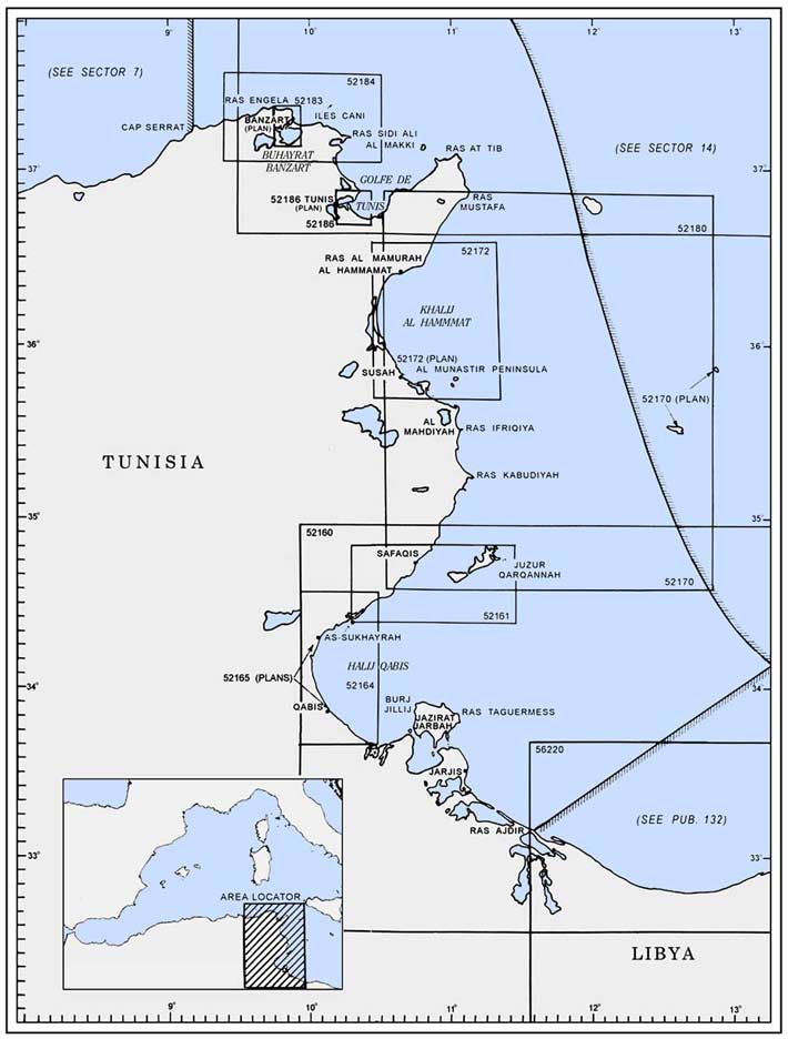
Plan. – This sector describes the N and E coasts of Tunisia. The descriptive sequence is from W to E and then N to S.
General Remarks
8.1 Tides – Currents. – In the vicinity of Cap Serrat, the currents are irregular and generally set with the prevailing wind.
In Baie de Banzart and at other places along the N coast of Tunisia, the tides are small and are often masked by the effects of the wind and atmospheric pressure which may cause the water level to vary by up to 1m.
Caution. – The winds in the vicinity of Cap Serrat are often accompanied by haze, which makes it difficult to distinguish the land.
8.2 Cap Serrat (37°14'N, 9°13'E), high and steep, is formed by a ridge which projects NE. Three summits, each about 186m high, stand on the ridge. A light is shown from a tower with a dwelling, 13m high, standing on the cape. A signal station is situated close S of the light.
Djebel el Hamar stands 4 miles S of the cape. This large and round mountain is 365m high. Djebel Zeizia stands 1 mile W of Djebel Hamar. It is 271m high and has a jagged summit. Djebel Blida stands 0.7 mile inland, 3.5 miles SE of the cape. It is 245m high and has three cone-shaped summits. Djebel Loko stands 0.6 mile inland, 5 miles ENE of Djebel Blida. It is 126m high and shaped like a sugar loaf.
Ragoubet el Goulea (Ras el Golea), a rocky point, is located 8.2 miles E of Cap Serrat. The coast between this point and Ras el Dukara, 8.5 miles ENE, is formed by rocky cliffs broken by dry ravines. Ras el Dukara may be identified by its ridge of serrated cliffs which rise in steps from the sea.
A depth of 20m was reported (1994) to lie about 4 miles NNW of Ras el Dukara.
The coast between Ras al Dukara and Ras el Korane (Ras el Kuran), 5.5 miles ENE, is formed by mostly small cliffs and rocks. These cliffs are broken by sandy beaches through which flow several small streams.
Ras el Korane is formed by rocks and gray sandstone and is rather flat. Between this point and Ras Ennghela, 4 miles E, the coast first consists of cliffs and then by a low plateau bordered by sand hills.
A conspicuous red tower stands close to the coast, 1 mile ESE of Ras el Korane.
Rashadat al Akhawat (Rchadet el Krouat) (Les Fratelli) (37°18'N, 9°25'E), a group of rocky islets and foul ground, lies about 2.5 miles NNE of Ragoubet al Goulea and is the outermost coastal danger.
Caution. – A danger area, the limits of which are shown on the chart, lies in the vicinity of this group of rocks.
8.3 Ras Ennghela (37°21'N, 9°45'E), the N point of Africa, consists of a low plateau and is fronted by rocks and shoals which extend up to 0.7 mile seaward. A light is shown from a structure, 15m high, standing on the point. The ruins of a tower are situated close to the light.
The coast between this point and Ar Ras al Abayd (Cap Blanc), 4.5 miles E, consists of a sandy beach followed by dunes and then cliffs.
Ar Ras al Abayd (Cap Blanc) (37°20'N, 9°50'E) is formed by a narrow projection. Its seaward sides consist of vertical white cliffs. A conspicuous signal station stands 0.6 mile S of the cape, and two prominent radio masts stand close WNW of it. A radiobeacon is situated at this signal station.
8.4 Ras Banzart (Cap Bizerte) (37°20'N, 9°52'E), located 1.2 miles E of Ar Ras al Abayd, is neither as high nor as steep, but is more salient. Three small, but prominent hills stand on this cape. A radar surveillance station, equipped with VHF, is situated on the cape.
A stranded wreck lies about 0.5 mile E of the cape.
Baie de Banzart (Baie de Bizerte) (37°18'N, 9°56'E) is entered between Ras Banzart and Ras al Zabib (Cap Zebib), 11 miles ESE. The city and port of Banzart (Bizerte) lie at the SW side of this bay.
Caution. – An IMO-adopted Traffic Separation Scheme (TSS) lies 17 miles NE of Ras Banzart (Cap Bizerte) and may best be seen on the chart.
Banzart (Bizerte) and Menzel Bourguiba (SidiAbdallah) (37°17'N, 9°53'E)
World Port Index No. 45440
8.5 The port of Banzart lies at the SW side of Baie de Banzart, 3.5 miles S of Ras Banzart. It consists mainly of Avant Port, Le Canal, Goulet du Lac, Lac de Bizerte, and Sidi Abdallah. The city of Banzart stands principally on the NW side of Le Canal. The town of Menzel Bourguiba stands close W of Sidi Abdallah.
Port of Bizerte Home Page http://www.ommp.nat.tn
Tides – Currents. – Tides rise about 0.4m at springs and 0.3m at neaps.
The current in the canal has been reported (1997) to reach rates of 1 to 2 knots.
Depths – Limitations. – Avant Port is protected by three breakwaters. Jetee Nord, 1,025m long, extends E from the coast and Jetee Est, 940m long, extends NNE from the coast. Dique Exterior, a detached breakwater, 610m long, lies off the entrance and may best be seen on the chart. The main entrance to the harbor lies between Jetee Est and Dique Exterior. The entrance between Dique Exterior and Jetee Nord is considered to be dangerous for large and/or single-screw vessels due to strong tidal currents.
A fishing harbor, protected by breakwaters, is situated close SE of Jetee Est.
The entrance to Avant Port is dredged to a depth of 12m. The N part of this basin is used by barges and small craft. Two oil berths are situated on the inner side of Jetee Est and have depths of 8.2 and 11m alongside. Tanker vessels up to 50,000 grt, 225m in length, and 11m draft can be accommodated.
Le Canal (Canal de Bizerte), quayed on both sides, is entered in the SW part of Avant Port and leads to Baie de Sebra. The fairway channel through Le Canal has been dredged to a depth of 11m. Quai de Commerce, on the N side, has 500m of total berthing space with a depth of 9m alongside. Quai de Cerealier, at the junction of Le Canal and Baie de Sebra, is used by bulk grain vessels. It is 220m long and has a depth of 9m alongside.
Quai de Tunisacier, 130m long, is situated on the N side of Baie de Sebra and has a depth of 9m alongside. Quai de Cimentier, 180m long, is situated on the SW side of the bay and has a depth of 9.8m alongside. A channel dredged to a depth of 10m and marked by lighted buoys leads to these facilities. Vessels up to 200m in length and 9.8m draft can be accommodated.
A lift bridge spans Le Canal 0.5 mile SW of the entrance. The lift span is 74m long.
Goulet du Lac extends SW for 3 miles from the SW end of Le Canal and then turns S into Lac de Bizerte (Buhayrat Banzart). A channel, marked by buoys, leads through Goulet du Lac and is dredged to a depth of 12m in the N part and 10m in the S part.
Baie Ponty and Baie de Seti Meriem, on the N side of Goulet du Lac, are the site of a naval station which has several finger piers with depths of 6m alongside.
Lac de Bizerte (Buhayrat Banzart) has general depths of 5.5 to 10m. A channel, marked by buoys, leads through the lake and connects Goulet du Lac with Sidi Abdallah (Menzel Bourquiba). It has a dredged depth of 10m.
Sidi Abdallah (Menzel Bourquiba) is an artificial harbor basin which is formed by breakwaters on three sides. The main entrance, 95m wide, is at the NE corner of the harbor and is approached by the dredged channel which leads through the lake. The town of Menzel Bourguiba (Manzil Bu Ruqaybah) stands close W of the harbor.
The N part of the harbor has a depth of 10m and the S part has depths of 5 to 10m. There is 460m of total berthing space with depths of 6.3 to 8.5m alongside. In addition, there are four drydocks, the largest being 247m long and 40m wide.
Aspect. – Djebel Kebir, 277m high, stands 2.7 miles SW of Ras Banzart and overlooks the city. It is the dominating landmark in the N approach.
A conspicuous hotel stands 0.4 mile inland, 2 miles S of Ras Banzart.
Fort Sidi Salem stands 3 miles S of Ras Banzart. The belfry in the barracks, situated 1 mile SSW of the fort, is prominent. A conspicuous building stands on the W side of Avant Port, 0.6 mile SSE of Fort Sidi Salem. Zarzuna Minaret stands on the S side of the harbor and is conspicuous.
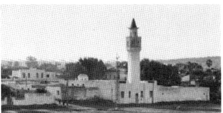 |
Banzart (Bizerte) – Zarzuna Minaret |
A number of prominent flares are situated about 1.2 miles SSW of the harbor entrance.
A light is shown from a prominent structure, 17m high, standing on the head of Jetee Est.
Pilotage. – Pilotage is compulsory for vessels of more than 300 gross tons.
Pilots may be contacted on VHF channel 14 or 16 and generally board about 1 mile ENE of the outer detached breakwater.
Regulations. – Vessels should send an ETA 72 hours, 48 hours, and 24 hours in advance.
Vessels must not exceed the minimum speed for safety and steerageway as far as Baie de Sebra, at the SW end of Le Canal.
Large vessels must enter and depart by the S entrance.
Submarines are prohibited from diving in an area lying S of the parallel of the SE head of the detached breakwater, and bound to the W by the meridian of the same head and to the E by the meridian of 9°58.5'E
The speed of vessels in Goulet du Lac must not exceed 6 knots.
Anchorage. – Large vessels can obtain anchorage, in a depth of 30m, about 1 mile E of the SE end of the detached breakwater.
Caution. – Banc du Boberak, with depths of less than 1.6m, extends up to about 0.5 mile from the coast, 2.3 miles SSE of Ras Banzart.
Submarine cables and pipelines cross Le Canal and may best be seen on the chart.
Due to submarine cables, prohibited anchorage areas, the limits of which are shown on the chart, lie within Goulet du Lac and extend seaward from close N of the harbor entrance.
The detached breakwater should be given a wide berth as it slopes underwater.
The head of Jetee Est should be given a wide berth due to masonry debris lying off it.
Several obstructions and wrecks lie in the approaches to the port and may best be seen on the chart.
It was reported (1989) that the breakwaters are not radar prominent until vessels are close to the harbor.
8.6 Ras al Zabib (Cab Zebib) (37°16'N, 10 °04'E), located 8.5 miles E of Banzart, can be easily identified by two conical hills, 90m high, standing on it. The extremity of this cape is low and fronted by foul ground.
Iles Cani (37°21'N, 10 °07'E) lies 6 miles NNE of Ras al Zabib. It consists of two islets, 18 and 20m high, standing on a rocky bank which extends 1.2 miles NE and SSW of them. A light is shown from a structure, 21m high, standing on the summit of the NE and higher of the two islets. A buoy, moored about 1.3 miles SW of the light, marks the SSW extension of the bank.
A depth of 9.5m was reported (1977) to lie about 5 miles NNE of Iles Cani. A wreck, with a depth of 18m, lies about 6 miles NE of Iles Cani. An isolated bank, with a depth of 17m, lies about 3.5 miles W of Iles Cani.
Caution. – An area dangerous for trawling, the limits of which are shown on the chart, lies 4.5 miles ENE of Iles Cani.
8.7 Ras Sidi ali el Mekki (Cap Farina), located 11.5 miles ESE of Ras al Zabib, is the E extremity of a narrow promontory and easy to identify. Between Ras al Zabib and this cape, the coast is rugged and backed by high mountains. A conspicuous shrine stands on a large sand hill close to the coast, 2.5 miles SE of Ras al Zabib.
Ile Pilau lies 1 mile offshore, 2.3 miles NW of Ras Sidi ali el Mekki. This islet is conical and 116m high.
Ile Plane, 9m high, lies 2 miles E of Ras Sidi ali el Mekki. A light is shown from a structure, 12m high, standing on the islet. A stranded wreck, which is radar conspicuous, lies on the NW side of the islet.
A bank, with a least depth of 12m, extends 2.8 miles NE from the islet.
Several rocky shoal patches lie within 1.5 miles of Ras Sidi ali el Mekki. The shallowest of these patches has a depth of 4.6m and lies about 1 mile NNE of the cape.
An isolated bank, with a least depth of 15m, lies about 12 miles NE of Ras Sidi ali el Mekki.
8.8 Golfe de Tunis is entered between Ras Sidi ali el Mekki (Cap Farina) and Ras at Tib (Cap Bon), 36 miles ESE.
Oued Medjerda flows into the gulf through a delta, 4.5 miles SSW of Ras Sidi ali el Mekki. Its mouth is fringed by a shoal bank which is constantly extending to the E.
The entrance to Lac de Porto Farina, a shallow lagoon, lies in a bay close NW of the river delta. A yacht harbor is situated close NE of the entrance.
Ras Quamart (Cap Gammarth), located 16 miles SSE of Ras Sidi ali el Mekki, is formed by a reddish cliff, 20m high. A rock, with a depth of 5.4m, lies about 0.4 mile NE of the point. A wreck, with a depth of 14m, lies about 4 miles ESE of the point.
8.9 Cap Carthage (Ras Qartajannah) (36°52'N, 10 °22'E) is located 3 miles SSE of Ras Quamart. Sidi Bou Said Light is shown from a structure, 12m high, standing on the cape. It was reported (1994) that this light structure was not easy to distinguish during the day from the other buildings in the vicinity. A stranded wreck, marked by a buoy, lies 0.3 mile NE of the cape.
A small harbor, protected by breakwaters, lies on the S side of the cape and is used by fishing craft and yachts. A conspicuous hotel stands on the beach close SW of this harbor.
The ruins of the ancient city of Carthage stand on the coast, 1.5 miles SW of the cape. A small white fort is situated close NE of them. The presidential palace stands 1.1 miles SW of the cape and is conspicuous.
Caution. – A navigation prohibited area, the limits of which are shown on the chart, is situated close offshore adjacent to the presidential palace. It is marked by orange floats and extends up to about 0.2 mile seaward.
Anchoring and fishing are prohibited in an area approximately 0.3 mile in radius, centered about 320m S of the presidential palace.
La Goulette (36°48'N, 10 °18'E)
World Port Index No. 45420
8.10 The harbor of La Goulette (Hala al Wadi) is situated 4.5 miles SW of Cap Carthage and serves as an outport for Tunis. It forms the entrance to Canal de Tunis, a dredged channel, which leads to the port of Tunis.
Depths – Limitations. – An approach channel, about 3 miles long, leads to the harbor entrance. It is 100m wide and dredged to a depth of 12.8m (1998).
The harbor is protected by two breakwaters and consists of an outer basin, a main basin, and Bassin de Rhades, which is a new inner basin situated on the S side of the canal.
The outer basin lies on the inner side of the W breakwater. It has depths of 3m and is mostly used by yachts and fishing craft.
The main basin, bordered on each side by quays, lies at the entrance to Canal de Tunis and has general depths of 10.5 to 12m. A turning circle, 300m wide and dredged to a depth of 12m, is situated within this basin.
North Quay, on the N side of the basin, has 1,097m of total berthing space, with a depth of 9m alongside. Facilities on the S side of the basin include a phosphate berth, 120m long, with a depth of 7.6m alongside; an ore berth, 80m long, with a depth of 9.8m alongside; a grain berth, 80m long, with a depth of 9.6m alongside; and a tanker berth, 150m long, with a depth of 8.1m alongside.
Bassin de Rhades has 1,200m of total berthing space, with a depth of 7.2 to 8.8m alongside. There are facilities for ro-ro and container vessels.
Vessels up to 185m in length and 8.8m draft can be accommodated. Tankers up to 180m in length and 8m draft can be accommodated.
Aspect. – The approach channel is marked by lighted buoys and an outer approach lighted buoy is moored about 3.5 miles ESE of the harbor entrance.
A light is shown from a structure, 11m high, standing at the head of the harbor, on the N bank. It is intensified between the bearings which lead through the harbor entrance.
The conspicuous cupola of St. Louis Chapel is situated on the N side of the harbor. A prominent clock tower stands 0.7 mile NW of the head of the N breakwater.
A monument and a steeple, both conspicuous, are situated 2 miles SW and 4.7 miles SSE, respectively, of the head of the N breakwater.
Fort de Sidi Ben Hassen stands in the S part of the city of Tunis and is conspicuous.
Prominent chimneys stand 1 mile WNW and 1.5 miles WSW, respectively, of the head of the N breakwater. A control tower and several silos stand on the S side of the harbor and are conspicuous from seaward. Djebel Resass, 795m high, stands 13 miles S of the harbor and is prominent.
Pilotage. – Pilotage is compulsory for all vessels over 100 grt. Pilots can be contacted on VHF channel 9, 10, or 16 and generally board within 0.3 mile of the outer approach lighted buoy. Pilotage is available 24 hours, except for tankers and ore carriers, when it is available during daylight hours only. Vessels should forward an ETA at least 12 hours in advance. Vessels in the canal should keep a listening watch on VHF channel 10.
Regulations. – Submarines are prohibited from diving in the area lying SW of the prolongation of a line joining Ras Qua-mart (Cap Gammarth) and Cap Carthage.
Vessels proceeding from the roadstead to the harbor must follow the approach channel for its entire length.
The maximum speed in the harbor is 5 knots.
Tankers and ore carriers are not allowed to enter or leave the harbor during the hours of darkness.
Anchorage. – Vessels can anchor in the roadstead sheltered only from winds between S and W. The best berth, in depths of 12 to 14m, lies between 0.5 and 1 mile N of the outer approach lighted buoy. Small vessels may anchor N or S of the approach channel, in depths of 7 to 9m, provided that they do not obstruct navigation. The bottom consists mostly of fine sand and affords good holding ground under normal conditions of wind and sea.
Caution. – A ferry crosses the harbor at La Goulette.
Several submarine cables cross the harbor, 1 mile WNW of the head of the N breakwater. Anchoring and fishing are prohibited in this area.
An overhead power cable, with a vertical clearance of 42m, spans the harbor close E of Bassin de Rhades.
World Port Index No. 45430
8.11 The port of Tunis lies 5 miles W of La Goulette (Hala al Wadi) and is approached through Canal de Tunis, which leads between masonry embankments across Lac de Tunis.
Winds – Weather. – Formation of a low pressure area in the mountains to the S of Tunis will usually result in rough weather in the roadstead with very little warning.
Depths – Limitations. – Canal de Tunis is dredged (1997) to a depth of 7m over a width of 45m. It is marked by lighted beacons and leads across Lac de Tunis to the port, which consists of three basins.
The harbor has 1,135m of total berthing space, with depths of 5 to 7.5m alongside, and facilities for ro-ro, container, and bulk vessels. Vessels up to 130m in length and 6.2m draft can be accommodated.
Aspect. – A conspicuous hotel stands 3 miles NW of the harbor.
A light is shown from a structure, 11m high, standing on the W side of the harbor. The light is intensified over a narrow sector covering the alignment of the canal.
Pilotage. – Pilotage for Canal de Tunis and the harbor is compulsory. Vessels should maintain a listening watch on VHF channel 10 while in the canal. See Pilotage for La Goulette in paragraph 8.10.
Caution. – A mid-channel course should be maintained as the cross section of the canal is V-shaped.
The speed of vessels in the canal is limited according to tonnage.
8.12 Pointe Er Reis (36°48'N, 10 °33'E) is located on the E side of Golfe de Tunis, 12 miles E of the harbor entrance at La Goulette (Halq al Wadi).
A bank, on which lies numerous rocks and wrecks, extends up to about 1.5 miles NW from a point on the coast, 2 miles SSW of Pointe Er Reis.
Ras Dourdass is located 4.5 miles NNE of Pointe Er Reis. The coast between is backed by a range of mountains.
Rass el Fartass, located 1.7 miles NE of Ras Dourdass, is steep and rocky. Its summit is 100m high and is surmounted by some ruins.
Rass el Ahmar (37°03'N, 10 °54'E), a low and rocky point, is located 18 miles NE of Rass el Fartass. A prominent hill, 97m high, stands 1.2 miles SSE of the point and from certain directions appears as an islet.
Sidi Daoud, a small harbor, lies 3 miles SSW of the point. It is protected by breakwaters and mostly used by fishing craft and yachts.
8.13 Ile Zembra (Djamour el Kebir) (37°08'N, 10 °48'E) lies 7 miles NW of Rass el Ahmar. This island is 435m high and an above-water rock lies about 0.5 mile W of its N extremity. A yacht harbor, protected by breakwaters, is situated on the S side of the island. A light is shown from the SW extremity of the island.
Ile Zembretta (Djamour es Srir), 49m high, lies 3.7 miles NNW of Ras el Ahmar. A light is shown from a structure, 8m high, standing on this islet.
Caution. – A dangerous wreck, marked by several buoys, lies about 1 mile SSE of the harbor entrance at Ile Zembra.
Vessels are advised to avoid navigating within an area which extends up to 1 mile from the S coast of Ile Zembra, due to yacht moorings.
Fishing is prohibited within 1.5 miles of Ile Zembra. Ile Zembra has been declared a military island and landing is prohibited.
8.14 Ras at Tib (Cap Bon) (37°05'N, 11°03'E), located 6.5 miles ENE of Rass el Ahmar, is the NE extremity of Tunisia and also of the mountainous promontory which sepa-rates Golfe de Tunis from the Gulf of Hammamet. A signal station surmounts the summit of the hill, which dominates the cape, and two prominent radio masts stand close W of it.
A light is shown from a structure, 20m high, standing 0.5 mile SE of the cape. A radiobeacon is situated 0.5 mile S of the light.
A shoal, with a least depth of 2m, lies close N of the cape.
Sidi Mohamed Ech Cherif, a marabout, stands on a hill 5 miles S of Ras at Tib (Cap Bon). It is large, prominent, and surrounded by trees.
Banc El Haouaria (37°20'N, 11°02'E) lies about 14.5 miles N of Ras at Tib (Cap Bon). This bank has a least depth of 22m and a dangerous wreck lies on it.
Caution. – An IMO-adopted Traffic Separation Scheme (TSS) lies 6 miles NNE of Ras at Tib (Cap Bon) and can best be seen on the chart.
8.15 Ras ed Drek (37°03'N, 11°04'E) is the S of three points which lie close together, 3.5 miles SE of Ras at Tib (Cap Bon). These points are fronted by rocks and shoals. The ruins of a fort surmount a ridge immediately above Ras ed Drek.
Caution. – Several lights and lighted buoys, one of which is equipped with a racon, lie close S of Ras ed Drek. These aids mark the landing area of two submarine gas pipelines which extend NE to the coast of Sicily.
Anchoring and fishing are prohibited in this vicinity. Vessels damaging these pipelines may incur serious risk of fire or explosion and loss of buoyancy.
8.16 Ras el Melah (36°52'N, 11°08'E), marked by a light, is located 11 miles SSE of Ras ed Drek. The point is low but rises to a large whitish sandhill. A shoal bank extends up to 0.5 mile from the point and an obstruction, with a depth of 16m, lies about 1.5 miles NNE of it.
Ras Mostefa (Ras Mustafa) (36°50'N, 11°07'E), located 2.5 miles SSW of Ras el Melah, is dominated by a conspicuous hill on which stands a large fortress. The cape consists of two sharp points, on the W of which stand the ruins of a battery and a marabout. A customhouse is situated close N of the marabout. Kelibia Light is shown from a structure, 18m high, standing on the E end of the fortress.
Caution. – Several submarine cables extend seaward from a point on the shore, 1 mile N of the cape. Anchorage is prohibited in the vicinity of these cables.
A dangerous wreck lies about 1.3 miles SSW of the cape.
8.17 Burj Qualaybiyah (Kelibia Bay) (36°50'N, 11°07'E) (World Port Index No. 45415), a very small harbor, lies in a bay on the W side of Ras Mostefa. It is protected by breakwaters and the entrance is 55m wide. There are depths of 5 to 7m in the SW part of the harbor, but the NE part is shoal. The harbor is mostly used by small craft and yachts with local knowledge. Qualaybiyah, a small town, stands at the head of the bay. It was reported (1988) that this harbor is used as a base for offshore oil and gas operations.
Anchorage can be taken off the harbor, about 0.5 mile SW of Ras Mostefa. The roadstead has depths of 11 to 15m and is sheltered from W and N winds. The bottom is mostly sand and the holding ground is good.
Tazerka Oil Terminal (36°36'N, 11°41'E) (World Port Index No. 45435), lies 31 miles SE of Ras el Melah. It consists of a floating production storage unit (FPSU) and the storage tanker Tazerka.
Pilotage. – Pilotage, docking, and getting underway are accomplished by a Berthing Master who remains onboard for the entire stay. Vessels should send an ETA upon departure from the previous port and update it 72 hours, 48 hours, and 24 hours prior to arrival. Any change of ETA of 3 hours should also be reported. The Berthing Master boards 2 miles off the FPSU.
8.18 Rass Maamoura (Ras al Mamurah) (36°27'N, 10 °48'E), located 27 miles SW of Ras Mostefa, is low and has a village standing on it. A conspicuous tomb stands on the shoulder of the SE foothill, 1.5 miles N of the point. A dangerous wreck lies close S of Rass Maamoura.
A small fishing harbor, protected by breakwaters, is situated on the S side of the point. A minaret stands 1 mile N of the harbor and is prominent from seaward.
Isolated banks, with depths of 26 to 28m, lie 15 miles ENE (Banc de Kourba), 5 miles S (Banc Nabeul), and 11 miles S (Banc Maamoura) of Rass Maamoura. These banks should be avoided in bad weather, especially during NE gales.
8.19 Golfe de Hammamet (Khalij al Hammamat) (36°10'N, 10 °40'E) is entered between Rass Maamoura and the Presqu’ile de Monastir, a peninsula 41 miles S.
Al Hammamet (36°24'N, 10 °37'E), a small fortified town, stands 10 miles WSW of Rass Maamoura. It is built on a low, sandy promontory, the S extremity of which is known as Ras Hammamet. The coast in this vicinity is built up with large hotels.
A tower, from which a light is shown, stands at the W angle of the fortifications of the town. A conspicuous church and a marabout are situated 0.7 mile and 1.2 miles WNW, respectively, of the tower. A conspicuous house stands on the coast, 0.8 mile NW of Ras Hammamet. A dangerous wreck, marked on its W side by a buoy, lies about 0.3 mile WNW of Ras Hammamet.
Anchorage, sheltered from N and NW winds, can be obtained, in a depth of 14m, off the town. The holding ground is fair and the bottom is mostly sand and grass; however, at times NW squalls blow down from the mountains.
Caution. – A submarine cable extends seaward from a point on the shore, 5 miles SW of Ras Hammamet.
8.20 Hergla (36°02'N, 10 °31'E), a small town, is situated 22 miles SSW of Al Hammamet. It is fronted by a small harbor which is protected by breakwaters marked by lights and used by fishing craft and yachts. The town can be identified by a prominent minaret, the dome of a mosque, and a prominent water tower.
In the vicinity of this town, the shore is rocky and numerous rocks, awash, lie close inshore. Farther to the S, the coast again becomes sandy.
El Kantaoui, an extensive yacht harbor, is situated 9.2 miles SE of Hergla near Rass Marsa and is protected by two jetties. A conspicuous hotel stands on the S side of the harbor.
Caution. – A stranded wreck lies midway between Rass Marsa and Sousse.
Sousse (Susah) (35°50'N, 10 °39'E)
World Port Index No. 45410
8.21 The port of Sousse lies in the SW part of Golfe de Hammamet, 38 miles SSW of Rass Maamoura.
Winds – Weather. – At times, heavy NW squalls descend from the mountains. The winds in winter are mainly between the NW and SW; in summer, they are mainly between the N and NE.
It is reported that strong N winds generate a current which make entry to the harbor very difficult.
Depths – Limitations. – The harbor is protected by a breakwater, 670m long, and is entered between two piers, 65m apart. The entrance channel is dredged (1986) to a depth of 8.5m.
A small basin, with a depth of 4.8m, lies in the SW part of the harbor and is used by fishing vessels. Another small basin, with depths of 1.8 to 3.9m, lies in the NW part of the harbor and is used by yachts.
The main commercial basin has 1,200m of total berthing space, with depths of 7.8 to 8.7m alongside. There are facilities for ro-ro, container, bulk, and tanker vessels. Vessels up to 165m in length and 8.7m draft have been accommodated.
Aspect. – A light is shown from a structure, 22m high, standing 0.8 mile WSW of the head of the breakwater. The approach to the entrance channel is marked by lighted buoys. An outer approach lighted buoy is moored about 0.6 mile E of the breakwater head.
Several prominent landmarks, including a church belfry in the NW part and the tower of a cathedral in the SW part, are situated in the town. However, it is reported that all landmarks are difficult to distinguish because of the multiplicity of them and because of haze.
Pilotage. – Pilotage is compulsory for vessels over 100 grt. Pilots may be contacted on VHF channel 10, 12, 16, or 67 and generally board off the entrance channel.
Anchorage. – Anchorage can be taken, in a depth of 11m, within the roadstead, but it is exposed to winds from the N to SE. The holding ground is poor, except during the summer when it may be considered good due to the deadening of the waves by seaweed. Vessels should anchor about 0.7 mile ESE of the head of the breakwater and S of the outer approach lighted buoy.
Caution. – It is reported (1991) that the lighted buoys marking the approach should not be relied upon.
A submarine pipeline, marked by a buoy, extends 0.5 mile E from a point on the shore, 0.8 mile NW of the head of the breakwater. Anchoring and fishing are prohibited in the vicinity of this pipeline.
8.22 Monastir (35°46'N, 10 °50'E), a town, is situated 10 miles ESE of Sousse. It is surrounded by battlement walls and stands at the NE end of Presqu’ile de Monastir, the peninsula which forms the S entrance point of Golfe de Hammamet. This peninsula is faced with rugged cliffs on its N side on which stand, at the W end, a large hotel, a stadium, a palace, and a large white house in ruins. A prominent marabout stands at the E end. The E side of the peninsula slopes gently to the sea.
Ile Egdemsi (Ile Sidi el Rhedamsi), 14m high, lies 0.2 mile off the NE side of the peninsula and is joined to it by a spit. A chimney and the buildings of a tunny fishery are situated on this islet.
An extensive yacht harbor is situated between the mainland and Ile Egdemsi, and an old fishing harbor lies close SE.
A fort standing 1 mile SSE of Monastir is prominent from seaward.
A conspicuous thermal power station stands 7 miles WNW of Monastir and is fronted by a small harbor, protected by breakwaters.
Caution. – A prohibited area, the limits of which are shown on the chart, extends up to 2 miles from the shore in the vicinity of the power station.
A dangerous wreck lies approximately 4 miles ESE of the light in the town of Monastir.
8.23 Ile Kuriate (35°48'N, 11°02'E), a low island, lies 10 miles ENE of Monastir. A light is shown from a structure, 26m high, standing on the summit of the island.
Ile Conigliera, a small and low island, lies 1.5 miles SSW of Ile Kuriate.
Tunny nets, up to 3.5 miles long, are laid out NW and NNW of these islands between the months of April and August.
A bank, with depths of less than 11m, extends up to 3 miles E of Ile Kuriate. In bad weather, heavy seas are encountered on this bank.
Several dangerous wrecks lie within 6 miles E and SE of Ile Kuriate and may best be seen on the chart.
Baie de Monastir (Baie dal Munastir) (35°43'N, 10 °54'E) lies between Presqu’ile de Monastir and a shallow spit extending NE, 8 miles SE. Several wrecks lie in the vicinity of this bay and the spit and may best be seen on the chart.
This bay offers very good anchorage, but it is exposed to N and NE winds. The masses of seaweed, which fringe the shore and surround the islands, deaden the sea and render anchorage in depths of less than 10m secure. Vessels can anchor at the E side of the spit.
Rass Dimasse (Ras Daymas) (35°38'N, 11°03'E), located 13 miles SE of Monastir, is low, fronted by a shoal bank, and hard to identify. A conspicuous mosque surmounts a hill, 1.2 miles SSW of the point. A prominent windmill stands 3 miles SSW of the point and a pier, with a flagstaff at its head, is situated 0.5 mile SE of it.
Cap Afrique (Ras Ifriqiya) (35°31'N, 11°05'E), is located 7 miles S of Rass Dimasse. It is also the extremity of a narrow peninsula.
8.24 Al Mahdiyah (Mahdia) (35°30'N, 11°04'E) (World Port Index No. 45400), a town, stands on the peninsula close W of the cape. A conspicuous tomb is situated near the extremity of the cape. A light is shown from a structure, 15m high, standing near the tomb. A conspicuous school building is situated 1.2 miles W of the light. A prominent castle and a prominent minaret stand 0.2 mile and 0.5 mile WSW, respectively, of the light.
A small harbor, protected by an outer breakwater and two inner breakwaters, lies on the S side of the narrow peninsula. It has depths of 2.3 to 4.5m and is reported to be used by small coasters. Anchorage can be taken S of the town in convenient depths. The bottom is rocky, but shelter is afforded from winds from the N to NE.
Rass Salakta, located 7 miles S of Cap Afrique, is fringed with rocks. In the vicinity of this point, the hills, which are 100m high, approach the coast and the beach gives way to vertical cliffs. A town, situated 3 miles WNW of the point, is visible from seaward. A small fishing harbor, protected by breakwaters, lies on the S side of the point.
8.25 Rass Kaboudia (Ras Kabudiyah) (35°14'N, 11°09'E), located 11 miles SSE of Rass Salakta, is the SE extremity of a rocky plateau which ends in a small peninsula. This peninsula is fringed with islets and a chimney, and the buildings of a tunny fishery are situated on it. A light is shown from a tower, 18m high, on the NE extremity of the point.
A small fishing harbor is situated close SSE of the point. A dangerous wreck, marked by a buoy, lies about 10 miles SSE of Rass Kaboudia.
Kerkennah Banks (Bancs Qarqannah) (35°00'N, 11°30'E) extend up to about 45 miles seaward from the coast between Rass Kaboudia and Ras Bou Rmada (Ras bu Ramadah), 52 miles SW. They are mostly formed of sand, mud, and weeds.
The seaward sides of the bank are fringed with shoals and are marked by lighted buoys. The outermost lighted buoy, which is moored about 40 miles SE of Rass Kaboudia is equipped with a racon.
Numerous wrecks lie in the vicinity of this bank and may best be seen on the chart.
Canal des Kerkennah (Majaz Qarqannah), a buoyed channel, leads SW across the inner part of the bank and is available to vessels with drafts up to 3m.
Iles Kerkennah (34°40'N, 11°10'E), consisting of Ile Chergui and Ile Gharbi, lie on the S part of the banks. These islands are low and difficult to identify from seaward.
Ile Chergui (Jazirat Ash Sharki) is the larger and NE island. A light is shown from a structure, 9m high, standing on the NW extremity of the island. A small fishing harbor is situated close SE of the light.
Another small fishing harbor is situated at El Attaia, 6 miles SSE of the light. A radiobeacon is situated in the vicinity of this harbor. A channel, marked by buoys, leads to the harbor. Its seaward entrance lies 4 miles SSE of El Attaia, but local knowledge is required.
Ile Gharbi (Jazirat al Gharbi) is the SW island. A small harbor is situated at Rass Sidi Youssef, its W extremity. A ferry boat runs from here to Sfax several times a day.
A lighted buoy, which marks the S edge of Kerkennah Banks, is moored about 12 miles SSW of Ras Sidi Youssef and is equipped with a racon.
Caution. – An anchoring and fishing prohibited area, the limits of which are shown on the chart, extends NW across Canal des Kerkennah from the W end of Ile Gharbi to the mainland.
Several dangerous wrecks lie in the S approaches to Canal des Kerkennah and may best be seen on the chart.
8.26 Ashtart Oil Terminal (34°17'N, 11°23'E) (World Port Index No. 45377) lies S of the banks, 26 miles SE of the S extremity of Ile Gharbi. It consists of a lighted offshore platform with flares; a large storage barge, moored 1 mile SSW of the platform; and an SBM situated 1.5 miles W of the platform. Submarine cables and pipelines connect these three facilities.
A radiobeacon is situated at the platform and transmits in low visibility when a tanker vessel is expected. The berths lie in a depth of 66m. Vessels up to 150,000 dwt can be accommodated at the SBM; in good weather, vessels up to 100,000 dwt can be accommodated alongside the storage barge.
Pilotage. – Pilotage is compulsory. Pilots generally board about 3 miles S of the platform.
Regulations. – Berthing is only permitted by day; one tug is available to assist.
The terminal can be contacted on VHF channel 6, 9, or 16. Unauthorized approach is prohibited.
Vessels should send an ETA 72 hours, 48 hours, and 24 hours in advance to SEREPT Sfax.
Anchorage. – Vessels may anchor, in a depth of 66m, about 6 miles S of the storage barge. Unauthorized anchoring within 3 miles of the terminal is prohibited.
World Port Index No. 45390
8.27 The port of Sfax lies W of Iles Kerkennah and 36 miles SW of Rass Kaboudia.
Tides – Currents. – The tides rise about 1.7m at springs and 1.1m at neaps. In the roadstead, the flood current sets NE and the ebb sets SW. They attain rates up to 1.7 knots at springs.
Depths – Limitations. – An approach channel, 2.5 miles long, leads NW to the harbor entrance. It is 40m wide and is dredged to a depth of 11m.
A fishing harbor, protected by breakwaters, lies close S of the main harbor and is entered by a narrow channel dredged to a depth of 5m; it has been reported (1996) that there is less water in the dredged channel.
The main commercial basins have 1,970m of total quayage, with depths of 10.3 to 10.5m alongside. There are facilities for general cargo, phosphate, salt, sulphur, container, ro-ro, and tanker vessels. Vessels up to 185m in length and 10.5m draft can be accommodated.
Aspect. – Towers, 18m and 207m high, stand close SW and 1.7 miles NW, respectively, of Ras Sidi Mansour, a point located 7 miles NE of the port.
The white buildings of the town are dominated by a tall minaret, the green-roofed tower of the town hall, and a domed tower standing near the waterfront.
Prominent marks include the cement factory and associated chimney situated 0.2 mile NW of the N basin; a tower standing at the SE entrance point of the outer basin; several storage tanks situated in the vicinity of the N basin; and the phosphate loaders and overhead transporter cranes standing on the quays.
A conspicuous house stands 2.3 miles W of the harbor entrance and three tall chimneys stand 0.5 mile E of it. A con-spicuous building, with a water tower close NE of it, is situated near a reservoir, 1.5 miles S of the above conspicuous house.
A light is shown from a structure, 17m high, standing on the quay at the NW side of the harbor. The light is intensified between the bearings which cover the entrance. The approach channel is marked by lighted buoys and beacons.
Pilotage. – Pilotage is compulsory for vessels over 100 grt. Pilots can be contacted on VHF channel 16 and generally board about 1 mile SE of the entrance to the approach channel. Vessels should send an ETA 12 hours in advance. Vessels intending to enter at night should send a confirmation at least 1 hour before sunset. Pilots are available 24 hours, but entry at night is inadvisable. Entry and departure by night is not permitted for tankers of any size.
Anchorage. – Sheltered anchorage, in convenient depths, can be taken in the roadstead. The holding ground is good and the bottom is mostly mud or sand and weeds. It is advisable to anchor NE of the entrance of the approach channel.
Caution. – A dangerous wreck lies adjacent to the N side of the approach channel, about 0.7 mile SE of the harbor entrance.
A wreck, with a depth of 3.9m, lies about 1.2 miles ESE of the harbor entrance. An isolated patch, with a depth of 3m, was reported (1962) to lie about 2.3 miles S of the harbor entrance. A submarine cable extends SE from a point close SW of the harbor entrance.
8.28 Ras Tina (34°38'N, 10 °43'E) is located 5.5 miles SW of Sfax. A small jetty is situated on the N side of this point. A light is shown from a prominent structure, 44m high, standing 1.5 miles WNW of the point.
The prominent village of Nakta, with a water tower, is situated 7.5 miles SW of Ras Tina.
Rass Bou Rmada (Ras Burmada) (34°31'N, 10 °33'E) is located 11 miles SW of Ras Tina. A wreck, with a depth of 10m, lies about 2.5 miles SSE of the point.
The small town of Mahares is situated 2.5 miles W of Rass Bou Rmada and is dominated by a prominent minaret and several shrines. Vessels with local knowledge can anchor, in depths of 6 to 12m, good holding ground, S of the minaret.
Rass Yonga (34°25'N, 10 °22'E), located 9 miles SW of Mahares, is low and hard to identify. A conspicuous mosque stands 1.5 miles WNW of the point.
Gulf de Gabes (Khalij Qabis) (33°54'N, 10 °07'E) lies between Rass Yonga and the NW extremity of Ile de Djerba, about 37 miles SE. The oil terminal of La Skhirra is situated in the NW part of the gulf and the port of Rhennouch (Ghannouche), with the town of Gabes, is situated in the SW part. The shores of the gulf are mostly fringed by sand banks.
Caution. – Drilling operations are being carried out in the gulf. The sites are usually marked by black and yellow buoys.
An anchorage prohibited area, with a radius of 1.5 miles, lies 12 miles SSW of Rass Yonga.
A gas pipeline runs N of the Ashtart Terminal to the Miskar gas field. The pipeline originates at the coast SE of the town of Nakta and is best seen on the chart.
8.29 Skhira el Kedima (34°20'N, 10 °10'E), a small projection, is located 11.5 miles SW of Rass Yonga. A small pier, with a depth of 1.2m at its head, extends 300m S from this projection.
Between Rass Yonga and Skhira el Kedima, the marshy coast is fronted by a bank of mud and weed which dries and extends up to 8 miles offshore. Several small rocky islets lie on this bank.
Ilot Kneiss lies on the bank, 4.5 miles SW of Rass Yonga. This islet is 7m high and a prominent geodetic pillar stands on it.
The seaward edge of the bank is marked by beacons. The W edge of the bank forms the E side of Baie des Sur-Kenis, which lies between the bank and the NW coast of the gulf. The W side of this bay is marked by rugged, red cliffs.
Oued ben Ghafef flows into the bay, 0.7 mile E of Skhira el Kedima. It is fronted by a bar across which a narrow channel, with a depth of 3m, leads. Small craft with local knowledge can enter the river.
8.30 La Skhira (As Sukhayrah) (34°17'N, 10 °06'E) (World Port Index No. 45380), an oil terminal, lies within the Baie des Sur Kenis, 1.2 miles SW of Skhira el Kedima.
Tides – Currents. – The tide rises about 2.1m at springs and 1.4m at neaps.
Depths – Limitations. – The terminal consists of a jetty which extends 1.2 miles SE from the shore. The berths consist of a pier, which extends SSW from the head of the jetty, and several mooring dolphins. The berths have depths of 14.5 to 15.3m alongside and tanker vessels up to 164,500 dwt, with a maximum length of 300m and a maximum draft of 15.5m at high water springs, can be accommodated.
Aspect. – A radio mast, 80m high, stands near the root of the terminal jetty and a prominent water tower is situated 1 mile ENE of it.
A light is shown from a structure standing 0.5 mile NW of the root of the jetty.
Several prominent storage tanks are situated close NW of the light. The village of Skhira, fronted by a breakwater and a disused light structure, is situated 3 miles SW of the terminal jetty. A ruined tower stands 3.7 miles SSW of the village.
Djebel Beida, 275m high, stands 16 miles SW of Skhira and is conspicuous.
Pilotage. – Pilotage is compulsory. Pilots can be contacted on VHF channel 11, 12, 14, or 16 and generally board between 1 and 2 miles S of the berths. Vessels should send an ETA 48 hours and 24 hours in advance. Messages should be sent to RAPETROL, La Skhira through La Skhira (3VP).
The approach to the terminal is marked by lighted buoys, which may best be seen on the chart.
Anchorage. – Vessels may anchor, in a depth of 18m, about 1 mile SSE of the head of the jetty or, in a depth of 23m, about 2.5 miles SSE of the head of the jetty. The anchorage is dangerous in W gales. Caution. – An anchorage prohibited area lies E of Lighted Buoy No. 1 and may best be seen on the chart.
Several wrecks and obstructions lie in the outer approaches to the port and may best be seen on the chart.
Gabes (Ghannouche) (33°54'N, 10°07'E)
World Port Index No. 45375
8.31 Gabes lies on the W side of Gulf de Gabes, 24 miles S of La Skhira. The port includes the commercial harbor of Ghannouche (Port de Rhennouch), which is entered through a dredged channel, and the fishing harbor of Gabes, situated 2 miles S.
Tides – Currents. – The tide rises about 2.1m at springs and 1.3m at neaps. The tidal currents set across the entrance channel, particularly near the breakwaters.
Depths – Limitations. – The commercial port is protected by two breakwaters. The approach channel is dredged to a depth of 12.5m. The main facilities include 975m of total quayage, with a depth of 10.5m alongside, and 785m of total quayage, with a depth of 12.5m alongside. There are facilities for general cargo, passenger, ro-ro, tanker, natural gas, ore, and bulk vessels. Vessels up to 11.8m draft can be accommodated.
The fishing harbor is protected by a curved breakwater and has depths of 3 to 4m within it.
Aspect. – The coast in the area of the port is generally low-lying with sand dunes fronting the beach. A range of hills, paralleling the coast, stands 4 miles inland and rises to heights of between 100m and 140m.
A cluster of industrial installations, situated to the W of the commercial harbor, can be seen from seaward. A prominent chimney, 44m high, stands at a power station, to the N of the commercial harbor. The dredged approach channel leading to the commercial harbor is marked by lighted buoys. An outer approach lighted buoy is moored about 2.6 miles NE of the heads of the breakwaters.
A light is shown from a structure, 11m high, standing close W of the fishing harbor. A conspicuous hotel is situated 0.5 mile SW of the light and a prominent mast, 106m high, stands close SW of the hotel.
It was reported that an aeronautical radiobeacon is situated in the vicinity of the airfield S of the town of Gabes.
Pilotage. – Pilotage is compulsory. Pilots can be contacted on VHF channel 12, 15, 16, or 17 and generally board in the vicinity of the outer approach lighted buoy.
It is reported that the VHF range is limited to under 12 miles. Anchorage. – Vessels can anchor, in depths of 12 to 24m, very poor holding ground, S of the dredged approach channel.
8.32 Rass el Djorf (33°42'N, 10 °43'E) is located 32 miles ESE of Gabes and formed by red cliffs, 15 to 18m high. The coast between is fronted by shoals which extend up to 2.5 miles offshore in places, especially in the approaches to Canal d’Adjim.
Guettaiet el Baharia, a low islet, lies in the W entrance to Canal d’Adjim, 1.5 miles N of Ras el Djorf.
Ile de Djerba (Jazirat Jerbah) (33°50'N, 10 °50'E), a large island, lies NE of Ras el Djorf and is flat and covered with palm trees. Khalij bu Ghirarah (Bahiret el Bou Grara), a landlocked bay, is formed by the indented S coast of the island and the indented coast of the mainland. Entry into this bay is from the W by Canal d’Adjim. Entry from the E is obstructed. The village of Adjim stands at the SW extremity of the island.
The entrance to Canal d’Adjim, the W channel, is marked by a lighted beacon situated 5.5 miles W of Rass el Djorf. Several narrow channels, marked by beacons and buoys, lead E and then SSE into Khalij bu Ghirarah from the vicinity of the lighted beacon.
Caution. – Although the bay has depths of 11 to 14m in its center, vessels are limited to a draft of about 3m because of shoaling at both ends of the channels. An overhead cable, with a vertical clearance of 30m, spans the channel, 1.2 miles SE of Rass el Djorf. A submarine cable crosses the channel close S of the overhead cable.
8.33 Bordj Djellidj (Burj Jillij) (33°53'N, 10 °45'E) is the S entrance point of the Golfe de Gabes and the NW extremity of Ile de Djerba. A small fort stands on the point. A light is shown from a structure, 12m high, standing on the NW corner of the fort. A prominent control tower stands 1.7 miles ESE of the fort and an aeronautical light is shown close SE of it.
The N coast of Ile de Djerba is fronted by a bank of mud and weed, which has depths of less than 5.5m and extends up to 3 miles offshore in places. Heavy seas are raised off the N edge of this bank by the slightest winds.
Dangerous wrecks lie about 8 miles NW and 13.5 miles NNW of Bordj Djellidj.
Caution. – A fish haven area, the limits of which are shown on the chart, lies 3.7 miles SW of Bordj Djellidj.
8.34 Houmt Souk (33°53'N, 10 °51'E) (World Port Index No. 45370), a small harbor, lies 5.5 miles E of Bordj Djellidj and is used by small coasters. A light is shown from a structure, 8m high, standing close SW of the harbor.
The harbor basin has depths of 1.5 to 4.5m and is protected by breakwaters which extend 0.2 mile N on each side of the entrance and cover at HW.
A buoy, marking the edge of the coastal bank, is moored about 4.2 miles NE of the light. Small vessels, with local knowledge, may enter the harbor by day through a secondary channel leading SSW across the flats from close S of the buoy. This channel, only 15m wide, is dredged to a depth of 4m.
A lighted approach buoy is moored about 4 miles N of the light and a main channel, marked by lighted beacons, leads S from it to the harbor basin. Vessels may anchor, although exposed to all but S winds, in the vicinity of this lighted approach buoy where there is good holding ground.
8.35 Rass Taguermess (33°49'N, 11°04'E) is located 10.5 miles ESE of Houmt Souk. A light is shown from a structure, 49m high, standing on a hill, 0.5 mile W of the point. A conspicuous hotel stands near the coast, 3.5 miles NW of the light. A conspicuous mosque stands 2.5 miles S of the white hills which back the point.
Vessels should give Rass Taguermess a wide berth as it is fringed with shoals and foul ground. Several dangerous wrecks lie offshore in this vicinity and may best be seen on the chart.
Aghir is located 4.7 miles SSW of Rass Taguermess. A prominent fort stands at this town and a light is shown from a structure, 6m high, standing on it.
Bordj Kastil (Bordj Castille), a prominent castle, stands on the extremity of a peninsula, 5 miles SSW of Aghir. Several mosques, situated inland, are also visible from seaward.
A series of low islets extends S from the peninsula and encloses a shallow bay. A causeway, lying 3 miles SW of Bordj Kastil, extends SSE from Ile de Djerba to the mainland and blocks the E entrance to Bahiret el Bou Grara.
Rass Marmour (33°37'N, 11°03'E), located 5.5 miles SE of Bordj Kastil, stands at the N extremity of a chain of hills faced with cliffs, which back this part of the coast.
Didon Oil Terminal (33°47'N, 11°53'E) is an SBM located approximately 45 miles E of Ile de Djerba. Pilotage is compulsory. Vessels should provide an ETA 7 days, 72 hours, 48 hours and 24 hours in advance of arrival. The pilot boards in position 33°47'N, 11°53.6'E
8.36 Zarzis (33°30'N, 11°07'E) (World Port Index No. 45365), a small harbor, lies 8 miles SSE of Rass Marmour. It is protected by a breakwater which extends 1 mile seaward, and is approached through a channel, 5 miles long, which is marked by buoys and is dredged to a depth of 13m. An outer approach lighted buoy is moored about 8.5 miles E of the harbor entrance.
A small fort is situated at Zarzis and two prominent marabouts, which are visible from seaward, stand 0.8 mile N and 2 miles S of the town.
The harbor basin has been dredged to a depth of 12m. Petroleum Quay, 640m long, has a depth of 12m alongside. Tanker vessels up to 185m in length and 10.5m draft can be accommodated. In addition, there are facilities for fishing vessels.
8.37 Ras Ajdir (33°10'N, 11°33'E) is located 30 miles SE of Zarzis. The coast between is low and backed by lagoons. The shore is fronted by a bank of sand and weed, which has depths of less than 20m and extends up to 12 miles offshore. Numerous shoals lie on this bank. The border between Tunisia and Libya lies in the vicinity of Ras Ajdir.
Burj al Biban, a conspicuous fort, stands on an islet near the entrance to a lagoon, 17 miles SE of Zarzis. Vessels, with local knowledge, can anchor, in a depth of 7m, good holding ground, about 8 miles NNE of the fort.
A tower beacon, 5.5m high, stands 10 miles NNE of the fort. A lighted buoy is moored near the edge of the coastal bank, about 2.5 miles NE of the tower beacon.
Caution. – Oil drilling operations are frequently carried out in the waters off the edge of the coastal bank.