ALGERIA – OUED KISS TO CAP MATIFOU SECTOR 6
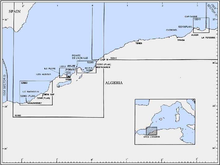
Plan. – This sector describes the coast of Algeria, between the outlet of the river Oued Kiss (35°05'N, 2°12'W), which is the seaward end of the boundary between Morocco and Algeria, and Cap Matifou (Bourdj el Bairi) (36°49'N, 3°14'E), which is the E entrance point of Baie d’Alger. The descriptive sequence is from W to E.
General Remarks
6.1 Tides – Currents. – A current usually sets along the stretch of coast between Ghazaouet and Beni Saf according to the direction of the wind.
A current usually sets in a NE direction along the coast between Cap Figalo and Cap Falcon.
A general current, which rarely attains a rate of more than 1 knot, sets NE and E along the coast between Cap Ivi (Ras Ouillis) and Cap Tenes.
Winds from the NW sometimes give rise to strong currents along the coast between the outlet of the Oued Mazafran and Cap Sidi Ferruch.
Caution. – Tunny nets may be found extending up to 7 miles offshore along this coast.
It is reported (1999) that commercial shipping within Algerian waters should exercise extreme caution and maintain adequate security measures.
Off-lying Islands and Islets
6.2 Ile Leila (Ile Rachgoun) (35°20'N, 1°29'W), 70m high, lies 1.2 miles NNW of Cap d’Acra. The island is barren, flat-topped, and fringed by rocks. A customhouse stands on its S end. A light is shown from a tower, 15m high, standing near the N end of the island.
The navigable channel, lying between the island and the mainland, is over 0.5 mile wide and vessels using it should favor the island side. A current usually sets through this channel in an E direction.
Anchorage, protected against N and NW winds, can be obtained in the channel S of the island. Small vessels anchor as close under the lee of the island as possible. The bottom is formed of mud and sand, but there are numerous rocky patches that must be avoided.
Iles Habibas (35°43'N, 1°08'W), consisting of two islands and numerous islets and rocks, lies 9.2 miles NNE of Cap Figalo. The NE and smallest island is 55m high, rounded, and flat-topped. The passage between the two islands is foul.
The larger and SW island is 105m high near its S extremity. A light is shown from a structure, 12m high, standing on the summit of this island.
Vessels proceeding through the channel between this group and the mainland should not approach within 1 mile of the islands. The currents in the vicinity of the group are strong and irregular.
Les Moules (35°42'N, 1°01'W), two rocks, lie 2.5 miles N of Cap Sigale. They are 6m and 7m high and are steep-to except on their N sides. Shoals lies up to 0.2 mile NE and up to 0.5 mile E of these rocks. A stranded wreck lies 0.5 mile SSW of the rocks.
Ile Plane (35°46'N, 0 °54'W), a large rock, lies 3 miles NE of Cap Lindles. It has an irregular summit that appears level from a distance. This rock is 18m high and steep-to, except off its W side, which is fronted by several small rocks. A light is shown from a structure, 6m high, standing on this rock.
Vesta Rock lies about 0.6 mile NNW of Ile Plane. It has a depth of 3.7m and does not break with a moderate sea. The channel lying between Ile Plane and Cap Lindles is clear of dangers.
Ilot Tokikt Indich (36°36'N, 1°51'E), 3m high, lies 3 miles NE of the village of Villebourg. This islet is flat-topped, rocky, and steep-to. It is marked by a light and should be given a wide berth in bad weather.
6.3 Le Kiss (35°05'N, 2°11'W), a village, is situated 0.5 mile E of Oued Kiss (Oued Skiss). The mouth of this river forms an opening which is clearly visible when approaching from the W. A bluff promontory, surmounted by a conspicuous white minaret, stands near the village and is prominent.
Open anchorage can be obtained, in a depth of 12m, mud and sand, NNW of the village.
Cap Milonia (35°06'N, 2°09'W), located 3 miles ENE of Oued Kiss, appears from the N as a rocky mass standing between two extensive beaches. It is fronted by foul ground and should not be closely approached.
Daklah, a hill, stands 0.7 mile S of the cape and is 212m high. It is surmounted by a signal station which operates only by day.
Cap El Kel’a (Pointe Bou Madane) is located 2 miles ESE of Cap Milonia. The E side of this point affords the only suitable anchorage during W winds on this coast. Kelah, a small loading port, lies at the E side of the point and has a transporter for loading ore. There is a quay, 111m long, with a depth of 7m alongside and several mooring buoys. Vessels up to 100m in length and 6.5m draft have been accommodated.
World Port Index No. 45670
6.4 The port of Ghazaouet (Nemours) lies 17 miles E of the mouth of Oued Kiss close to the border with Morocco and is protected by a breakwater.
Port of Ghazaouet Home Page http://www.portdeghazaouet.com
Tides – Currents. – There is no tidal rise. The water level increases with W winds and decreases with E winds. Usually, variations in the level are less than 0.3m.
Depths – Limitations. – The harbor is approached through an outer channel, 225m wide, with depths of 12 to 20m, and through an inner channel, 166m wide, with a depth of 10m.
The main facilities are situated within three basins. Bassin de Skikda (N part of East Basin) lies in the NE part of the harbor and contains seven berths. It has 677m of total berthing space, with depths of 6.8 to 7.2m alongside.
Bassin d’Oran lies in the SE part of the harbor (S part of East Basin) and contains six berths. It has 631m of total berthing space with depths of 7.0 to 7.3m alongside.
Bassin de Macherek (West Basin) lies in the S part of the harbor and contains four berths. It has 409m of total berthing space, with a depth of 8.5m alongside.
There are facilities for tanker, bulk, and ro-ro vessels. Vessels up to 180m in length and 8.5m draft can be accommodated.
Aspect. – Djebel Fillaoussene, 1,136m high, and Tadjera, 861m high, stand 10 miles SE and 9.5 miles ENE, respectively, of the harbor and are the most prominent distant landmarks.
Plateau de Touent, a tableland, stands at the E end of the port and dominates the town. It is surmounted by a watch tower which is a radar station.
The harbor is protected on the N side by a breakwater which extends 0.6 mile W from the W side of Plateau de Touent.
A light is shown from a structure, 12m high, standing 0.5 mile SSW of the breakwater head. When approaching from the E, this light is obscured by Plateau de Touent. A conspicuous chimney is reported to stand 0.5 mile SSE of the breakwater head.
Les Deux Freres, two columnar rocks, lie on the S side of the harbor entrance. The W and taller of these rocks is 24m high and is marked by a light. Two above-water rocks lie between these rocks and the coast.
Pilotage. – Pilotage is compulsory. Pilots may be contacted on VHF channel 12 or 16 and generally board about 0.3 mile NW of the entrance.
Regulations. – Vessels should provide an ETA 24 hours in advance and must receive permission by VHF from the port control office before entering the harbor. Vessels must remain W of the entrance while awaiting the pilot and maintain a listening watch on VHF channel 14 or 16 during the wait.
Anchorage. – Open anchorage can be obtained, in depths of 18 to 22m, N of the breakwater. The roadstead has a fairly good holding ground of fine sand, but it is not recommended in bad weather.
Caution. – During W winds, entry requires care because of the swell in the entrance and in the W part of the harbor.
The N breakwater should not be approached closer than 20m, because of its underwater slope.
A wreck, with a depth of 33m, lies about 1.2 miles NE of the harbor entrance.
6.5 Cap Tarsa (Tarca) (35°08'N, 1°48'W), located 3.5 miles NE of Ghazaouet, is formed by a whitish, rocky, double headland. Baie Erkene, entered close E of the cape, affords temporary shelter from W winds.
Mers Arobat and Oued Kiouma are two conspicuous breaks in the line of rocky cliffs, 90m high, which extend from near Cap Tarsa to Cap Noe, 6.5 miles NE.
Mersa Honaine (Baie de Honain) is entered on the E side of Cap Noe and affords shelter. Small vessels, with local knowledge, can anchor, in a depth of 6m, muddy sand, good holding ground, close offshore; however, it is exposed to NW winds.
The ruins of a town, with a conspicuous tower standing close NE, are situated behind the beach at the head of the bay.
Ile de Mokrane (35°13'N, 1°38'W), lying 3.5 miles NE of Cap Noe, is a conspicuous islet. Two pointed rocks, 40m high, stand at its W end. The passage inshore of the islet is obstructed by rocks.
Loubar Damah (Khizrane), located 2.5 miles NE of Ile de Mokrane, is a small peninsula which can be identified by three rocks lying close off it. Coves, used by small craft, lie on each side of this peninsula.
Ile Nigria (Ile Ronde) lies about 0.3 mile off the coast, 8.5 miles NE of Cap Noe. This islet is 28m high and has vertical sides.
Djebel Bou Keltoum, 364m high, stands 1.5 miles ESE of Ile Nigria and its summit is surmounted by a prominent watch tower.
Anse Sidi Medani, located 2.3 miles E of Ile Nigria, is bordered by conspicuous red and yellow cliffs. A white shrine stands on the summit of a hill, close S of this small bay.
Ile Leila (Ile Rachgoun) (35°19'N, 1°29'W), lying 4.7 miles NE of Ile Nigria, is described in paragraph 6.2.
Dzira es Srhira (Ilot Siga) lies 0.2 mile N of the coast, 1.8 miles NE of Anse Sidi Medani. This islet is 18m high and several rocks lie between it and the mainland.
Cap d’Acra (35°19'N, 1°28'W) is located 1 mile ENE of Dzira es Srhira. Le Pain de Sucre, a small islet, lies close offshore, 1 mile E of the cape.
6.6 Beni Saf (35°18'N, 1°23'W) (World Port Index No. 45660), a small port, lies 3.5 miles E of Cap d’Acra and is mostly used for the export of iron mining products.
Tides – Current. – There is no apparent tidal rise. An E current is reported to exist off the harbor entrance.
Depths – Limitations. – An outer breakwater extends about 200m NNW and then 500m NE. The harbor entrance is 160m wide. The main facilities include West Quay, 200m long, with depths of 8.5 to 9m alongside, and East Quay, 70m long, with depths of 6 to 8m alongside. Vessels up to 170m in length and 8.5m draft can be accommodated.
Pilotage. – Pilotage is not compulsory, but is recommended. Pilots are available from Ghazaouet with advance notice. The port can be contacted on VHF channel 16.
Anchorage. – Vessels may anchor in the harbor and secure their sterns to one of the jetties. The holding ground is good, being of fine sand. Anchorage can also be taken, in depths of 20 to 28m, about 0.5 mile N of the harbor.
Caution. – A sand bank extends about 320m NE from the head of the breakwater. The harbor is subject to silting.
In heavy weather, seas may break up to 1 mile offshore and entry is dangerous. During fresh N or NW winds, local knowledge is required as entry is somewhat difficult.
6.7 Hafa Ta’chlouh, located 4 miles NE of Beni Saf, rises to Aouaria, a rounded and conical summit, 273m high.
Djebel Sidi Kassem, 353m high, and Dar Touila, 307m high, stand 7 miles and 11 miles, respectively, NE of Cap Oulassa. Both of these peaks are conspicuous from seaward.
6.8 Cap Figalo (Cap Fegalo) (35°34'N, 1°12'W), located 15 miles NNE of Cap Oulassa, is easily recognized from all directions. It rises steeply to a rounded hill, 182m high, which is surmounted by a prominent signal station. Several conical rocks lie close off this cape and a small islet, with a pointed summit, lies 0.3 mile W of it.
Cap Sigale (Cap Blanc) is located 11 miles NE of Cap Figalo. The coast between is backed by hills up to 400m high. The cape is formed by a long, rounded projection, 305m high, and is faced with a conspicuous white cliff.
Les Moules (35°42'N, 1°01'W) lie off Cap Sigale and are described in paragraph 6.2. Cap Lindles, located 5 miles NE of Cap Signale, is faced with steep cliffs.
Baie des Andalouses is entered between Cap Lindles and Pointe Corales, 6 miles NE. This bay affords shelter from winds from the ENE through S to WSW. Vessels may anchor in its W part over a bottom of sand.
Pointe Corales is formed by the NW extremity of a promontory, 67m high, and is fronted by several above-water rocks. An airport is situated 2 miles SSE of the point.
Cap Falcon (35°46'N, 0 °48'W) is the rocky NE extremity of the promontory of which Pointe Corales is the NW extremity. From a distance, this cape appears as an island. Two large above-water rocks lie close NE of the cape and an islet, fringed with rocks, lies 0.2 mile N of the N side of the cape. A light is shown from a tower, 27m high, standing on the cape.
6.9 Golfe d’Oran (35°46'N, 0 °43'W) lies between Cap Falcon and Cap de l’Aiguille, 17 miles ENE. The ports of Mers el Kebir and Oran are situated at the head of this bight.
Cap Gros, located 4.7 miles ESE of Cap Falcon, is 70m high. Ain-el-Turk, a village, is situated 3.5 miles W of this cape. A prominent belfry stands in the village, and a conspicuous group of radio masts is situated 0.8 mile NW of it.
Caution. – A submarine cable area, the limits of which are indicated on the chart, extends seaward between Cap Falcon and Cap Gros.
A bank, with a least depth of 15m, lies about 2.7 miles NW of Cap Gros.
A submerged target lies 2.7 miles NNE of Cap Gros. An anchoring and trawling prohibited area, the limits of which are shown on the chart, is situated in the vicinity of this target.
6.10 Mers el Kebir (35°44'N, 0 °42'W) (World Port Index No. 45650) lies on the SW side of Golfe d’Oran, close S of Cap Gros. It mostly consists of naval installations and a military harbor.
Tides – Currents. – Due to W winds, the general current in Golfe d’Oran sets to the E and rebounds off Cap de l’Aiguille, creating a countercurrent. The latter passes along the coast and the jetties of the port. With E winds, the general current sets W without a countercurrent.
Depths – Limitations. – The harbor can accommodate vessels of moderate size. The commercial facilities include three moles, with depths of 8.5 to 9m alongside, and a quay, situated in the S part of the harbor, with a depth of 12m alongside.
Aspect. – A small peninsula projects 0.5 mile E from close S of Cap Gros and is surmounted by a fort. The N breakwater extends 0.5 mile SE and then 0.6 mile ESE from the extremity of this peninsula.
Djebel Santon, 306m high, stands 0.7 mile WSW of the peninsula and a prominent fort is situated on its summit.
Djebel Murdjadjo, 509m high, stands between Mers el Kabir and Oran. From the NW to NE, this hill appears flat-topped with a vertical fall at the E end which joins an elevated but lower plain. The conspicuous fort of Santa Cruz stands at a height of 352m at its E end. A prominent chapel is situated close below and to the E of the fort.
The S breakwater extends 300m N and then 0.8 mile NW from a point on the shore, 0.2 mile N of the chapel.
A lighted range indicates the fairway between the two breakwater heads and may best be seen on the chart.
Pilotage. – Pilotage is compulsory. Pilots can be contacted by VHF and board close outside of the entrance.
Regulations. – Mers el Kebir is a military port. All merchant, fishing, and pleasure vessels are prohibited from navigating in the entrance and approaches. Entry is only possible with authorization secured from the naval authorities at Oran.
Caution. – Winds from the N may render several alongside berths untenable. Winds from the WSW sometimes produce heavy swells within the harbor. Winds from the SW and NW, which are more frequent, may cause waves to slam against some of the quays. Winds from the NE and ENE are rare but troublesome, and produce swells from 3 to 4m high in the harbor entrance. With W winds, violent squalls sometimes blow through a ravine in the high land and force vessels to leave the harbor.
World Port Index No. 45640
6.11 The port of Oran lies at the head of Golfe d’Oran, close E of Mers el Kebir, and is protected by breakwaters.
Port of Oran Home Page http://www.oran-port.com
Tides – Currents. – The tidal rise varies little throughout the year. Winds from the W raise the water level in the harbor and winds from the E lower it. The level may vary by up to 0.7m.
During W gales, a current sets S across the harbor entrance.
Depths – Limitations. – The harbor is divided into seven basins.
Bassin Ghazaovet, situated at the inner end of the harbor, is mostly used by small naval vessels. Vieux Port Basin, situated S of Bassin Ghazaovet, is mostly used by harbor service craft and pleasure craft.
The main facilities within the other five basins include about 4,000m of total berthing space, with depths of 6.1 to 12m alongside. In addition, there is 448m of total berthing space for tankers with depths of 9.8 to 11.6m alongside.
There are facilities for general cargo, tankers, ro-ro, container, and bulk vessels. Vessels up to 244m in length and 11.6m draft can be accommodated.
Aspect. – Pointe Mona is located 0.3 mile E of the root of the S breakwater at Mers el Kebir. This point is surmounted by Fort Lamoune and has a conspicuous cave at its W side.
Jetee Filaoussene, the N breakwater, extends 1.5 miles in an E direction from Pointe Mona.
A prominent cathedral stands in the city, which has a tier-like appearance from seaward, 0.9 mile SE of the root of the N breakwater. A very conspicuous high -rise apartment building stands 0.7 mile SE of the head of the N breakwater. The Aloudja Farm, situated 0.5 mile E of the apartment building, is surrounded by trees and stands isolated at the top of a cliff.
The harbor entrance lies between the extremity of a spur, which projects SSE from close inside the N breakwater, and Traverse du Large, a breakwater, which extends NNW from the coast. A light is shown from a prominent structure, 15m high, standing on the head of the N breakwater.
Pilotage. – Pilotage is compulsory. Pilots may be contacted on VHF channel 12, 14, or 16. Vessels should contact the pilot station 3 hours prior to arrival. Pilots board 0.5 mile N of the breakwater entrance.
Anchorage. – Anchorage is available in the roadstead and within the harbor. The best anchorage, in depths of 26 to 40m, is off the entrance, but clear of the prohibited area.
Caution. – An anchoring prohibited area lies adjacent to the harbor entrance and in the outer port and may best be seen on the chart.
Several wrecks lie in the vicinity of the harbor entrance and may best be seen on the chart. A submarine cable lies within the harbor and may best be seen on the chart.
6.12 Pointe Canastel (Kef el Menzah) (35°47'N, 0 °33'W), located 5 miles NE of the entrance to Oran, is fringed with rocks and rises to a steep-sided hill, 123m high. A conspicuous stranded wreck lies close to the shore, 0.5 mile SW of the point.
Djebel Khar, 620m high, stands 2.7 miles E of the point. It is isolated and is visible up to 50 miles seaward in clear weather.
Cap de l’Aiguille (35°53'N, 0 °29'W), located 5.7 miles NNE of Pointe Canastel, is formed by a rocky projection which is dominated by a hill, 225m high. A light is shown from a structure, 11m high, standing on the cape.
Djebel Kristel, 510m high, stands 2 miles SE of the cape. A disused signal station tower stands on the summit. Djebel Orousse, 631m high, stands 1.5 miles ENE of Djebel Kristel.
Rocher de l’Aiguille, 48m high, lies 1 mile NE of Cap de l’Aiguille. This conical rock is joined to the coast by a reef.
Cap Ferrat (35°55'N, 0 °23'W), located 5.2 miles ENE of Cap de l’Aiguille, is rocky and 215m high. A prominent hill, 398m high, stands 1.3 miles S of the cape.
Cape Carbon (35°55'N, 0 °20'W), 141m high, rises to a rocky rounded hill, which from a distance NW, appears detached. This cape is the NW extremity of the promontory of which Cap Ferrat is the W extremity. It is fronted by rocks and shoals which extend up to 0.6 mile seaward.
Golfe d’Arzew
6.13 Golfe d’Arzew (35°52'N, 0 °08'W) is entered between Cap Carbon and Cap Ivi (Ras Ouilles) (36°07'N, 0 °13'E), 30 miles ENE. The port of Arzew is situated at the W side of the gulf. Port de Bethioua (Arzew El-Djedid), a natural gas terminal, is situated at the head. Mostaganem is situated at the E side of the gulf.
Ile d’Arzew is the SE of a group of islets which lie about 0.2 mile off the coast, 3 miles SE of Cap Carbon. A light is shown from a structure, 19m high, standing on this islet. The whole group is fringed with rocks and shoals.
Banc de Madrague, with a least depth of 9.3m, lies about 1 mile SSE of Ile d’Arzew and is marked by a lighted buoy.
Banc des Trois Doigts, with a least depth of 4.3m, extends up to about 0.2 mile offshore, 0.6 mile S of Ile d’Arzew.
The town of Arzew is not visible from seaward until close off it, but Arzew Hill, 216m high, stands 2.7 miles S of Cap Carbon and is prominent.
Numerous prominent structures, associated with the oil and gas industry, stand along the coast of the gulf which extends S and SE from the town of Arzew.
A prominent power station stands 2.5 miles E of Port de Bettioua (Arzew el Djedid) and a conspicuous white house is situated close E of it.
The town of Mostaganem is conspicuous from seaward because its white buildings show up well against the grey hills of the background.
Oued Cheliff flows into the sea through a conspicuous ravine, 6.5 miles SW of Cap Ivi. From the W, a prominent detached conical hill appears in the ravine about 1 mile inland. The river is spanned by an iron bridge, 0.5 mile from its mouth, and a conspicuous building stands on its N bank. A low point, formed by the alluvium of the river, extends seaward from the high land on either side of the ravine; this point is extending seaward and should be given a wide berth.
The red, muddy waters discharged by this river can generally be observed as far as 2 miles from the mouth. These waters have been carried as far as 15 miles to the N by strong W winds.
Winds – Weather. – It should be noted that at times the seas are high in the gulf. With strong NW or N winds, such seas are deflected SW by the E shore of the gulf between Mostaganem and Cap Ivi and reach the roadstead off Arzew.
Tides – Currents. – A W current, which is strong at times, usually sets along the shore of the gulf and flows E out of the gulf at Arzew.
Caution. – The shores of the gulf are, in most places, low and the background hills stand at some distance inland. Caution is necessary at night or in bad weather, because the land appears to be much farther off than it is in reality.
Several wrecks and obstructions lie within the gulf and may best be seen on the chart.
A submarine pipeline extends 2.5 miles SW from a point on the E shore of the gulf, 4.5 miles NNE of Mostaganem. Its seaward end is marked by a buoy.
World Port Index No. 45630
6.14 The port of Arzew lies on the W side of Golfe d’Arzew, 1.3 mile SSW of Ile d’Arzew. It consists of a harbor, protected by a breakwater and a jetty, and an offshore sea terminal.
Depths – Limitations. – The harbor is protected on its E side by Jetee du Large, a breakwater, which extends 0.3 mile SSE and then 0.4 mile SE from the shore close S of Fort de la Pointe. It is also protected on the S side by Jetee Secondaire, which extends 0.3 mile NE from the shore of the bay.
General cargo and bulk quays, which are situated in the N part of the harbor, have 900m of total berthing space with depths of 5 of 8m alongside. They can accommodate vessels with drafts up to 7.2m.
Jetee Methanier, which extends from the W side of the harbor, has two methane berths, each 400m long with a depth of 9.8m alongside. Vessels up to 40,000 cubic meters capacity and 9.4m draft can be accommodated.
Jetee Secondaire has two LPG and Ammonia berths with depths of 10 to 11m alongside. Vessels up to 25,000 cubic meters capacity and 9.8m draft can be accommodated.
Three tanker berths are situated at the inner side of Jetee du Large and have depths of 10 to 15.5m alongside. Vessels up to 120,000 dwt and 14.9m draft can be accommodated.
An offshore sea terminal lies 1.4 miles SE of the head of Jetee du Large, in a depth of 26m. A submarine pipeline extends SW from the terminal berth to the shore of the bay. This terminal can accommodate vessels up to 250,000 dwt.
A fishing jetty is situated in the NW section of the harbor.
Aspect. – Fort de la Pointe stands 0.9 mile SSW of Ile d’Arzew and Jetee Abri, a breakwater, extends 250m ESE from the shore adjacent to it.
The town of Arzew is not visible from the offing, but a number of prominent structures, associated with the oil and gas industry, extend along the coast for 2.5 miles S and SE of the town. One of these, a conspicuous flare, is situated at a natural gas plant, 1 mile WSW of the head of Jetee du Large. In addition, four other prominent flares are situated in the vicinity of Arzew El-Djedid.
Lighted buoys are moored 1.5 miles E and 0.9 mile SE of the harbor entrance and indicate the approach. Another lighted buoy is moored close ESE of the head of Jetee du Large.
For additional information, see Golfe d’Arzew in paragraph 6.13.
Pilotage. – Pilotage is compulsory for vessels intending to enter the harbor or anchor. Pilots can be contacted on VHF channel 13, 14, or 16 and generally board about 2.5 miles ESE of the entrance or at the anchorage. Vessels should send an ETA message 72 hours and 48 hours in advance, with a confirmation 12 hours before arrival, through Saint Lys (FFL).
Anchorage. – The roadstead is sheltered from winds from the N to NNE, but heavy seas are sometimes experienced, especially with NW winds. The bottom consists of mostly rocks, sand, and mud. Vessels waiting to berth should anchor, in a depth of 69m, in the vicinity of the pilot boarding place, about 2.3 miles E of the head of Jetee du Large. The holding ground is reported to be poor.
Caution. – Draft limitations should be confirmed with the port authority prior to entering the harbor.
Lighted buoys at the port are reported to be unreliable.
An anchoring and fishing prohibited area, the limits of which are shown on the chart, extends up to 0.8 mile E of the head of Jetee Abri.
A tanker prohibited anchorage area, the limits of which are shown on the chart, extends up to 4 miles NE of the port.
Tunny nets may be found, from July to December, within an area, the limits of which are shown on the chart, lying 0.3 mile SE of Ile d’Arzew.
World Port Index No. 45635
6.15 Port de Bettioua (Arzew el Djedid) lies at the head of Golfe d’Arzew, 2 miles SE of Arzew. The harbor is used for the export of natural gas and fronts the town of Bettioua.
Depths – Limitations. – The harbor is protected by a detached breakwater, 1 mile long, which lies parallel to the shore and 0.7 mile from it. In addition, E and W breakwaters extend seaward from the coast.
There are six LNG berths, 430 to 480m long, each with a depth of 13.5m alongside. Vessels up to 200,000 cubic meters can be accommodated.
There is one LPG and Ammonia Berth, 360m long, with a depth of 13m alongside. Vessels up to 120,000 cubic meters can be accommodated.
There are three crude concentrate berths, 460 to 480m long, with depths of 23.5 to 26.5m alongside. Vessels up to 250,000 dwt and 26.4m draft can be accommodated.
Aspect. – See Arzew (paragraph 6.14) and Golfe d’Arzew (paragraph 6.13).
Lighted buoys are moored close off the ends of the detached breakwater.
Pilotage. – Pilotage is compulsory. Pilots can be contacted on VHF channel 12 and generally board (two pilots) about 1 mile NE of the E entrance. Link calls by VHF can be established through Arzew (7TW) and Oran (7TO).
Anchorage. – Vessels generally anchor, in depths of 60 to 70m, between 1 and 1.5 miles N of the detached breakwater. The holding ground is reported to be poor.
Caution. – A dangerous wreck lies in the E approaches to the harbor, 2 miles ENE of the E end of the detached breakwater.
World Port Index No. 45620
6.16 The port of Mostaganem (Mestghanem) lies on the E side of Golfe d’Arzew, 7 miles SSW of the mouth of Oued Chelif.
Port of Mostaganem Home Page http://www.mosta-port.com
Depths – Limitations. – The harbor is protected by Jetee du Large, a breakwater, which extends 0.7 mile SW from the N part of the town.
The main facilities consist of eight berths, 115 to 217m long, with depths of 4 to 8.2m alongside. There are facilities for general cargo, bulk, ro-ro, and fishing vessels. Vessels up to 180m in length and 8.2m draft can be accommodated.
Aspect. – The buildings of the town are prominent. A spire, situated at the E side of the town, is conspicuous. A light is shown from a structure, 10m high, standing at the head of Jetee du Large. A lighted buoy is moored about 0.7 mile SW of the head of Jetee du Large and marks the coastal bank. For additional landmarks, see Golfe d’Arzew (paragraph 6.13).
Pilotage. – Pilotage is compulsory. Pilots can be contacted on VHF channel 16 and generally board about 0.5 mile from the entrance. Except in the case of an emergency, entry does not take place at night.
Anchorage. – Anchorage can be obtained, in a depth of 25m, about 0.7 mile W of the harbor entrance; the bottom is clay covered with sand, but there are some rocky patches which should be avoided.
Caution. – The roadstead is completely exposed and winds from between the W and N render it dangerous.
During the strong N and W winds and high seas of winter and spring, the port is subject to frequent closings.
6.17 Cap Ivi (Ras Ouilles) (36°07'N, 0 °14'E) is not a conspicuous landmark, but is backed by mountains. From the SW and NE, this cape appears as a plateau, 20m high, falling steeply to the sea. A light is shown from a tower surmounting a building, 18m high, standing on the cape.
A patch of dark vegetation, 31m high, stands on a large white sandhill, close W of the cape.
Djebel Korima, 294m high, stands 1.5 miles SE of Cap Ivi. A prominent reddish watch tower is situated on its summit and a village stands on its NE slope.
Kef el Asfer, located 7 miles NE of Cap Ivi, is a low and dangerous point. In bad weather, vessels may be deceived by the loom of the hills behind it, which stand some distance inland.
Oued Kaddous, located 13.5 miles NE of Kef el Asfer, is easily identified from the N. A conical hill, 119m high, stands on its E side and is surmounted by a building.
Oued Khamis, located 3 miles NE of Oued Kaddous, is open to the W and easily identified from the W and NW by several large yellow sand hills which stand near it.
Cap Kramis (36°20'N, 0 °40'E), located 1 mile NE of Oued Khamis, is faced with steep cliffs which appear red when illuminated by the setting sun.
Djebel Srim, 778m high, Djebel Tachta, 787m high, and Djebel Hallouda, 821m high, stand between 6 and 9 miles SE of the cape and are conspicuous. When seen from between the WNW and NNW, these mountains appear as a saddle-shaped group.
Pointe Colombi (36°26'N, 0 °56'E) is located 15 miles NE of Cap Kramis. A light is shown from a structure, 29m high, standing on the point.
Ile Colombi (Ilot Nadji) lies about 0.3 mile offshore, 1 mile WSW of the point. It is 29m high and marked by a lighted beacon.
Pointe Rouge is located 8 miles ENE of Pointe Colombi. Small vessels, with local knowledge, can anchor in El Mersa, a bay, entered close E of the point.
Cap Kalah (36°20'N, 0 °40'E), located 4 miles ENE of Pointe Rouge, is fronted by a rock, 6m high. Small vessels, with local knowledge, can anchor in Baie de Mainis, which is entered 2 miles E of the cape.
Jebel Bou Mecaoud, 748m high, stands 3 miles SSW of the cape and is prominent.
6.18 Tenes (36°32'N, 1°19'E) (World Port Index No. 45610), a small port, lies 6 miles ENE of Cap Kalah and is protected by a detached breakwater.
Depths – Limitations. – The harbor can be entered from either end. The W entrance is preferred, as the E entrance is suitable only for small craft. There is 420m of total berthing space with depth of 6 to 7m alongside. Vessels up to 120m in length and 6.4m draft can be accommodated.
The port is difficult for large vessels to maneuver in.
Aspect. – A conspicuous grain silo, 47m high, stands on the SW jetty of the harbor. The town is situated 1 mile SW of the harbor and is prominent.
Pilotage. – Pilotage is compulsory of more than 100 nrt. The port may be contacted on VHF channel 14 or 16 and a private pilot is reported to be available. Local knowledge is advised. Tugs are compulsory for vessels of more than 500 gross tons.
Anchorage. – During the summer, anchorage can be obtained, in depths of 14 to 16m, sand, good holding ground, about 0.6 mile N or NNW of the town. During the winter, it is advisable to anchor farther NW because of the W winds.
Caution. – The roadstead is exposed to winds from between the W and N, and the sea breaks at a considerable distance offshore.
 |
Cap Tenes from W |
 |
Cap Tenes from E |
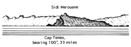
6.19 Cap Tenes (36°33'N, 1°22'E), located 1.7 miles NE of Tenes, extends 2 miles E from its W extremity. It is rocky and dominated by Sidi Merouane, 642m high. From the W or E, the cape appears, at a distance, to be steep-sided with a rounded top surmounted by a sharp peak. From the N, it appears lower than in reality.
A light is shown from a tower, 26m high, standing on the W end of the cape. A radiobeacon is situated at the light.
Djebel Taznount, 786m high, stands 4 miles SE of the cape and is conspicuous.
Baie de Terarenia is entered 0.8 mile SSE of Kef Arend, the E extremity of the cape. It affords shelter from W winds. Vessels, with local knowledge, can anchor, in depths of 8 to 12m, 0.3 mile from the head of the bay.
Souhalia, a conical mountain, stands close to the shore, 3 miles E of Baie de Terarenia. It is 307m high and fairly conspicuous. Baie des Soulhalias, entered 1.5 miles E of this mountain, affords anchorage in its E part in good weather.
Pointe Abd el Kaderar, located 10.5 miles E of Cap Tenes, rises to a hill, 274m high ; the W slope of this hill forms a point, through which, from the NE to SW, runs a tunnel.
6.20 Baie des Beni Haoua (36°32'N, 1°35'E) lies between Pointe Abd el Kader and Ilot Sidi Djilani, 1.2 miles E. It affords anchorage, sheltered from E winds, in the lee of Ilot Sidi Djilani to small vessels.
Djebel Bou Touil, 624m high, stands 3 miles ESE of Baie des Beni Haoua and is prominent.
Rocher Djilari, 8m high, stands in the middle of a sandy beach, 6.5 miles E of Pointe Abd el Kader. A rock, awash, lies about 0.2 mile N of Rocher Djilari.
Oued Damous enters the sea 0.7 mile E of Rocher Djilari. It flows through a conspicuous gap in the mountains which are 488 to 610m high.
Villebourg (36°33'N, 1°48'E), a prominent village, is situated 5.5 miles E of the mouth of Oued Damous. Small vessels, with local knowledge, can obtain anchorage off this village in good weather.
Ilot Tokikt Indich (36°36'N, 1°51'E) lies 3 miles NE of the village and is described in paragraph 6.2.
Gouraya, another village, is situated 5 miles E of Villebourg. It is easily identified by the white houses which show up against a green background.
Pointe Teska (36°35'N, 1°55'E), located 0.8 mile E of Gouraya, ends in low cliffs. This point is surmounted by some ruins and fringed by a reef.
Ilot Taourira, a small islet, lies close offshore, 7 miles E of Pointe Teska. It is round-backed and 10m high.
Novi, a village, is situated 3.2 miles E of Ilot Taourira and is conspicuous from seaward.
6.21 Cherchel (36°37'N, 2°11'E) (World Port Index No. 45590), a small port, lies 13.5 miles E of Pointe Teska. The harbor is situated between Ilot Joinville and the coast, close S of it.
Depths – Limitations. – The entrance fairway is 24m wide. There is 520m of total berthing space with depths of 3.5 to 4.2m alongside. Small vessels up to 3.6m draft can be accommodated. An open roadstead for large vessels which should only be used in fair weather.
Aspect. – The town, situated immediately S of the harbor area, stands out against a background of green hills.
A light is shown from a tower, 26m high, standing on the summit of Ilot Joinville. This light tower is conspicuous against the sky when approaching from the E or W, and against a background of vegetation when approaching from the N.
Anchorage. – The roadstead is entirely exposed and even moderate breezes raise a heavy sea. In good weather, anchorage can be obtained, in a depth of 14m, sand, off the harbor, but great care should be taken because the bottom is rocky in many places.
6.22 Cap Blanc (36°37'N, 2°14'E), located 2.3 miles E of Cherchel, is faced with yellow cliffs.
Ecueil du Sphinx, a shoal, is located 2.5 miles ENE of Cap Blanc. It has a least depth of 1.8m and lies at the N end of a rocky spit.
Ilot Berinshel, 20m high, lies about 0.3 mile offshore, 5.2 miles ENE of Cap Blanc. This islet is surrounded by foul ground.
Ras el Amouch (36°38'N, 2°24'E) is located 8 miles ENE of Cap Blanc. A prominent hill, 158m high, stands above this point and is surmounted by a disused signal station.
Djebel Chenoua, 904m high, stands 2.2 miles SW of the point and is very conspicuous.
Cap Chenoua, about 0.5 mile SSE of Ras el Amouch, is marked by a factory.
Anse des Carrieres is entered between Ras el Amouch and Cap Chenoua, 0.6 mile SSE. Small vessels, with local knowledge, can obtain shelter within this bay. Anchorage can be taken, in a depth of 9m, sand and rocky patches, about 0.2 mile offshore. A prominent factory is situated on Cap Chenoua.
Baie de Chenoua, a small and open bay, is entered S of Cap Chenoua. It affords shelter from W and NW winds to small vessels with local knowledge. Anchorage can be obtained, in depths of 12 to 13m, sand, about 0.2 mile offshore.
6.23 Ras el Kalia (36°36'N, 2°27'E) is located 3 miles SE of Ras el Amouch. A light is shown from a structure painted in yellow squares with the upper part green, 11m high, standing on the point. A prominent radio mast is situated about 2 miles SE of the point.
Banc des Romains, with depths of 8 to 18m, lies about 0.4 mile NNE of the point. Ilots Sidi-Said, two small islets, lie on a shoal bank, about 0.5 mile E of the point.
Tipasa (36°36'N, 2°27'E) (World Port Index No. 45580), a small town, is situated close SSE of Ras el Kalia and is fronted by a small craft harbor. Large vessels can obtain open anchorage, in depths of 20 to 30m, off the town, N of Banc des Romains. Small vessels can anchor, in depths of 12 to 14m, S of this bank.
Tombeau de la Chretienne, a conspicuous landmark, stands 5 miles ESE of Tipasa and surmounts the crest of a range of rocky hills which border the coast. It consists of a rugged cone, 33m high, which at a distance, appears as a large haystack.
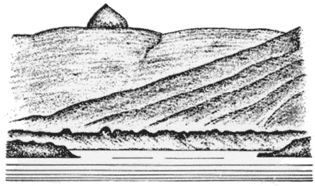 |
Tombeau de la Chretienne, bearing 125°, distant 3 miles |
Bou Aroun and Chiffalo, two small and shallow fishing boat harbors, front the coast 10.5 miles and 11.5 miles, respectively, ENE of Tipasa.
Oued Mazafran flows into the sea 8 miles NE of Bou Aroun. In good weather, anchorage can be obtained by small vessels, with local knowledge, off the stretch of coast between Tipasa and the mouth of this river.
Vessels can anchor, in a depth of 18m, SW of and about 0.5 mile from a large rock lying close off the W extremity of Cap Sidi Ferruch (36°46'N, 2°51'E).
Small vessels, with local knowledge, can obtain anchorage off Ain Benian (Guyotville) (36°48'N, 2°56'E).
6.24 Cap Sidi Ferruch (36°46'N, 2°51'E), located 4.5 miles NE of the mouth of Oued Mazafran, is formed by a small peninsula and fronted by several islets. A light is shown from a structure, 24m high, standing on the NE part of the cape. A small craft harbor is situated on the NE side of the peninsula.
Ras Acrata, located 3.5 miles NE of Cap Sidi Ferruch, is the W extremity of a large promontory. This point is fronted by rocks; a small craft harbor is situated 0.5 mile SE of it.
Ain Benian (Guyotyville), a small fishing harbor, is situated 1 mile E of Ras Acrata.
An aeronautical light is reported to be occasionally shown from the tower of an airfield, situated 22.5 miles S of Ras Acrata.
Cap Caxine (36°49'N, 2°57'E) is located 2.7 miles E of Ras Acrata. A light is shown from a tower with a dwelling, 33m high, standing on the cape.
A swell gauge buoy lies 0.5 mile NNW of the cape.
A wreck lies N of Cap Caxine in position 36°54'N 2°54'E
Pointe Pescade, located 2.7 miles E of Cap Caxine, is the N extremity of the Cap Caxine promontory. It is formed by a double point. The W part ends in a flat islet which is almost joined to the shore. The E part is fronted by two islets and surmounted by the ruins of a fort and a water tower.
Small vessels, with local knowledge, can obtain anchorage, sheltered from W winds, in the lee of Pointe Pescade.
6.25 Baie d’Alger is entered between Pointe Pescade and Cap Matifou, 10 miles E. Its shores consist mostly of sandy beaches.
The promontory of Cap Caxine is dominated by a range of hills, 407m high, standing 1.5 miles S of Pointe Pescade.
When approaching the bay from the N, the high land in the vicinity of Cap Caxine appears as if detached from the mainland, for it is separated from the mountains of the interior by a level plain. On nearer approach, Cap Matifou also may appear as an island.
Bou Zegzag, 1,032m high, stands 16 miles SE of Cap Matifou and can be identified from the N by its summit, which is in the form of a small cone rising from a level but irregular crest.
Cape Matifou (Bourdj el Bairi) (36°49'N, 3°14'E), the E entrance point of the bay, is formed by the W extremity of a low headland. Banc de Matifou lies in the E approach to the bay, 2.3 miles N of this cape. Both are fully described in paragraph 7.3.
World Port Index No. 45570
6.26 The port of Alger (Algiers) (El Djazair) lies on the W side of Baie d’Alger, 7.2 miles WSW of Cap Matifou. In addition to having extensive and important commercial facilities, the port is also a naval base.
Port of Alger Home Page http://www.portalger.com.dz
Tides – Currents. – There are practically no tides; the maximum reported rise is about 0.7m.
Winds from the W may raise the level of the water in the harbor and winds from E may lower it; the difference in level may be as much as 0.9m.
Depths – Limitations. – The N approach channel is 176m wide and has a depth of 22m. The S approach is 240m wide and has a depth of 16m.
The N part of the harbor is protected from the NE by Jetee Kheir Eddine, a breakwater which extends 0.7 mile SE from Ilot de la Marine. The S part of the harbor is protected from the E by Brise Lames de l’Est, a breakwater which extends 0.4 mile N from the shore. The central part of the harbor is protected by a detached breakwater, 1.4 miles long, which may best be seen on the chart.
The harbor is divided into three basins, as follows:
- Bassin du Viuex Port, lying in the N part, has 3,000m of total berthing space, with depths of 6.4 to 18.2m alongside.
- Bassin de Mustapha, lying in the S part, can be entered through an entrance, 200m wide. It has 2,700m of total berthing space, with depths of 7 to 11m alongside.
- Arriere Port de l’Agha, lying in the central part, can only be entered from the other two basins. It has 2,700m of total berthing space, with depths of 6.4 to 9.8m alongside. There are facilities for general cargo, ro-ro, bulk, container, cruise, tanker, LNG, and fishing vessels. Vessels up to 25,000 tons, unlimited length, and 11.6m draft can be accommodated.
It has been reported (2001) that vessels will not be taken pierside if they have a draft greater than 10m.
Aspect. – Several forts surmount the heights overlooking Alger and a conspicuous television mast stands 1.5 miles S of Pointe Pescade.
Ilot de la Marine is located 3.3 miles SE of Pointe Pescade and is joined to the shore by a mole. A prominent disused light tower stands on this islet.
Roche M’Tahen lies about 0.3 mile offshore, 0.5 mile N of Ilot de la Marine. It is the outermost rock fronting the coast to the N of the port and is marked by a lighted beacon.
The church of Notre Dame d’Afrique stands about 0.3 mile inland, 1.5 miles NW of Ilot de la Marine; its prominent dome is surmounted by a cross which is sometimes illuminated at night.
Fort l’Empereur, a conspicuous building, stands 1.3 miles SW of Ilot de la Marine and is 216m high.
A conspicuous monument stands about 0.6 mile inland, 2.5 miles S of Ilot de la Marine. A prominent tower is situated 0.3 mile W of this monument.
A conspicuous military hospital is situated near the coast, 0.9 mile NW of Ilot de la Marine. A light is shown from a structure, 16m high, standing near the head of the N breakwater.
It has been reported (2001) that aeronautical radiobeacon towers on both sides of the bay are visible well out to sea.
Pilotage. – Pilotage is compulsory for vessels over 1,500 tons and is usually only available during daylight hours. Pilots can be contacted on VHF channel 12 or 16 and generally board about 0.5 mile E of the S head of the detached breakwater. Vessels should send an ETA at least 24 hours in advance.
Merchant vessels can communicate through Bouzarea (Bouzareah) Naval Signal Station, which stands on the heights, 2 miles NW of Ilot de la Marine. A signal station is also situated on the N breakwater and is available for communication with vessels in the roadstead, when it is not otherwise engaged.
Regulations. – Vessels approaching or leaving the port must follow the channel, which is indicated on the chart. It is entered 5 miles E of Pointe Pescade and leads in a SSW direction towards the harbor. Vessels leaving the port have priority over those entering the port. Anchoring in this approach channel is prohibited.
Anchorage. – Four anchorage areas, the limits of which are shown on the chart, have been established (1982) within Baie d’Alger, as follows:
- Area No. 1 lies N of the N breakwater and is used by vessels not carrying any dangerous substances.
- Area No. 2 lies centered 2 miles E of the head of the N breakwater and is used by vessels carrying dangerous substances or gas.
- Area No. 3 lies close E of the detached breakwater and is used by vessels of small tonnage with authorization of the Port Captain. The bottom has been reported (2001) to be hard clay vice mud.
- Area No. 4 lies SSW of Cap Matifou and is used by vessels waiting, sheltering, or carrying out repairs. Caution. – Due to construction being carried out, vessels should stay well clear of the heads of the breakwaters.
A dangerous wreck is reported to lie about 1.2 miles NE of Ilot de la Marine.
Due to the existence of submarine cables, a prohibited anchorage area, the limits of which are shown on the chart, extends N from the vicinity of the of the head of Baie d’Alger.
It is reported (1990) that the designated anchorage areas, which are described above, are not in use and vessels anchor anywhere in the roadstead, regardless of size.
It is reported (1993) that all buoys marking the approach channel and anchorage areas have been removed.
A dangerous wreck is reported (2006) to lie in the S part of Anchorage Area No. 2.