SPAIN – GREAT EUROPA POINT TO CABO DE PALOS SECTOR 2
Plan. – This sector first describes the E coast of Gibraltar from Great Europa Point to the Spanish border. It then describes the Mediterranean coast of Spain as far as Cabo de Palos (37°38'N, 0 °41'W).
General Remarks
2.1 Numerous dangerous wrecks lie within 2 miles of the coasts described in this sector and may best be seen on the charts.
Numerous outfall pipelines extend up to 0.8 mile seaward from the coasts described in this sector. Several submarine cables lie within the waters described in this sector and may best be seen on the charts.
Explosive Dumping Ground Areas, the limits of which are shown on the chart, lie 2.7 miles SE of Europa Point and 8 miles S of Cartagena.
Submarines frequently exercise in the area lying E of the Strait of Gibraltar.
Caution is necessary when estimating the distance from the seaward edge of the plain of Llanos de Almeria (Campo de Dalias) (36°45'N, 2°43'W), as, due to its blending with the horizon and being backed by high land, its apparent distance is often misleading.
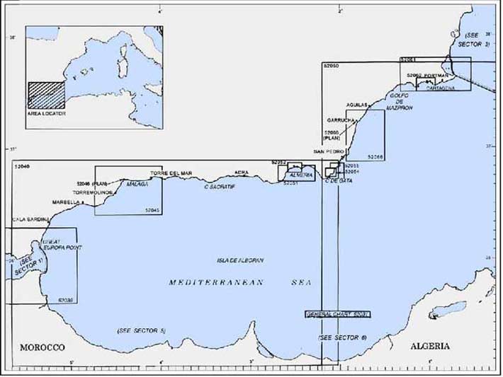
2.2 Isla de Alboran (35°56'N, 3°02'W), a Spanish possession, lies 50 miles SSE of Cabo Sacratif. This island is flat, reddish, and about 20m high . The cliffs on its S side are steep, but they are less so on its N side. Islote de la Nube lies close NE of Punta del Islote, the NE extremity of the island. Both the island and the islet are fringed with sunken rocks, and depths of less than 11m lie within 0.2 mile of the island in several directions. A light is shown from a tower with a dwelling, 19m high, standing near the SW extremity of the island.
Temporary anchorage, affording some shelter from W and NW winds, can be obtained by vessels, in depths of 16 to 20m, between 0.3 and 0.4 mile E of the light. However, it is reported that several unmarked submarine cables lie near this anchorage. A circular fishing prohibited area, best seen on the chart, surrounds the island.
Placer de Las Bovedas (36°25'N, 4°59'W), an extensive bank, lies 8 miles SW of Marbella and has a least charted depth of 17m, sand and rock. It has been reported by local mariners and fishermen that a very steep-to patch, with a depth of only 14.6m, exists on this bank.
Vessels should avoid passing over the bank, especially in heavy seas, as rocky heads, with less depths than those charted, may exist.
Chella Bank (36°31'N, 2°51'W) lies 16 miles SE of Adra and has a least depth of 72m. An isolated patch, with a least depth of 40m, was reported (1981) to lie about 15 miles SW of Cabo de Gata.
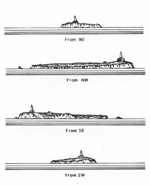 |
Four views of Isla de Alboran |
2.3 Great Europa Point (36°07'N, 5°21'W) has been previously described in paragraph 1.8 in connection with the entrance to the Bay of Gibraltar.
The E side of Gibraltar is steep and inaccessible. The large rainwater catchment, situated 1.5 miles N of Great Europa Point, is very conspicuous. A conspicuous white hotel stands at the S end of Catalan Bay, close N of this catchment.
A jetty, 87m long, is situated 1 mile N of Great Europa Point. It has a depth of 5.5m alongside the head and is used by naval vessels.
A lighted float is moored 0.5 mile E of the E end of the airport runway.
Sierra Carbonera, 315m high, rises 3.5 miles N of the runway at Gibraltar. This mountain and the Rock of Gibraltar form a valley, which from the E and in poor visibility, has been mistaken for the approach to the Strait of Gibraltar. Torreon, an ancient and prominent watch tower, stands at an elevation of 285m, nearly 0.5 mile S of the highest point of Sierra Carbonera. A conspicuous radio tower, 70m high, stands close N of this watch tower.
Punta Torre Nueva, a low and rocky point, is located 6 miles NNE of Great Europa Point. A coast guard station stands near this point and a small yacht harbor, protected by breakwaters, is situated 1.7 miles SSW of it. A more extensive breakwater is found 0.2 mile S of the yacht basin. This structure extends E into Blackstrap Bay for almost 0.9 mile.
Punta Mala (Punta Carbonera), marked by a light, is located 2.6 miles NNE of Punta Torre Nueva. This point consists of reddish rock. An ODAS lighted buoy has been established 12 miles E of Punta Mala in position 36°14'N, 5°01.5'W
The Rio Guadjaro flows into the sea, 2.5 miles NNE of Punta Mala. Its mouth is protected by two short breakwaters and fronted by a shallow bar. An extensive yacht harbor, protected by breakwaters, is situated 0.6 mile N of the river mouth.
2.4 Punta de la Chullera (36°19'N, 5°15'W), located 2.3 miles NNE of the mouth of the Rio Guadjaro, is of moderate elevation and is fronted by a reef. Torre de la Chullera stands on a hill above the point.
Piedra Alcorrin, a small islet, lies close offshore, 1.5 miles NNE of Punta de la Chullera. This islet is fringed with rocks and several rocky heads, some of which dry, lying N of it.
An extensive yacht harbor, protected by breakwaters, is situated 1 mile N of Piedra Alcorrin.
Between Piedra Alcorrin and Punta Torre de Salto de la Mora, 2.7 miles NNE, there is the sandy shore of Fondeadero de la Sabanilla, through which five streams flow into the sea.
Castillo de la Sabanilla, a ruined tower, stands close to the shore, 1 mile N of Piedra Alcorrin. A disused factory and a chimney, 38m high, are situated 0.7 mile NNE of the ruined tower. La Sabinilla, an important fishing village, is situated 1 mile NNE of Castillo de la Sabanilla. Manilva, a town, stands 1.5 miles NW of La Sabanilla on moderately high ground and is clearly visible from seaward. The Rio Manilva flows from the N part of the town and enters the sea 0.5 mile N of La Sabanilla.
2.5 Punta del Salto de la Mora (36°23'N, 5°13'W) is located 1 mile NE of La Sabanilla. This point is rocky and surmounted by a prominent tower.
Laja de Salto de la Mora, a drying shoal, is the outermost of a group of dangers which lie within 0.3 mile E of the point. This shoal is usually marked by breakers and should be given a wide berth.
Anchorage can be obtained, by vessels with local knowledge, anywhere off this part of the coast, in suitable depths, as far S as Mala Bahia.
Torre de Arroyo Vaquero stands on a small hill dominating a rocky point, 1.5 miles NE of Punta del Salto de la Mora. The coast in this vicinity is rocky and fronted by reefs. Costra Natura, with conspicuous pyramid-shaped buildings, is situated close NNE of Torre de Arroyo Vaquero.
Sierra Bermeja (36°29'N, 5°12'W), one of the most prominent features along this coast, stands 6 miles N of Punta del Salto de la Mora. This mountain rises to a rocky, cone-shaped peak, 1,452m high, and is visible from a great distance.
Punta de la Sal Vieja (36°25'N, 5°10'W) is located 3.2 miles NE of Punta del Salto de la Mora, and several submerged rocks extend up to 0.2 mile S of it. Roquero de Alfero, a detached rocky patch, lies 0.4 mile S of the point and has depths of 9 to 13m. A prominent tower stands near the point, and Las Mesas, 96m high, rises 0.6 mile NNW of the point.
2.6 Puerto de Estepona (36°25'N, 5°09'W) (World Port Index No. 38350 ), an extensive yacht harbor, lies between Punta de la Sal Viejo and Punta de la Doncella, 0.4 mile ENE. It is protected by two breakwaters and has an entrance 80m wide. There are depths of 5m in the entrance and 3 to 4.5m within the basins. Anchorage can be taken, in a depth of 13m, about 0.7 mile E of Punta de la Doncella. A light is shown from a tower with a dwelling, 21m high, standing on Punta de la Doncella. A lighted buoy is moored about 0.7 mile ENE of the light and marks the seaward extremity of several coast protection groins.
Punta de los Marmoles, low and fringed with a beach, is located 1.5 miles NE of Puerto de Estepona. Several rocky heads, with depths of 5 to 8m, lie within 0.5 mile SE of this point. Roqueros de la Cipresses, with a least depth of 10m, lies 0.5 mile S of the point.
Torre del Padron stands on a moderately-high hill, 3 miles ENE of Puerto de Estepona. A prominent steel bridge spans the mouth of the Rio del Padron, close E of this tower.
Punta del Castor (36°26'N, 5°06'W), located 1 mile NE of Torre del Padron, is low and projects little from the coast. This point is fronted by several rocks and a river flows into the sea close W of it.
Punta de Guadalmaza, a sandy point, is located 1.7 miles E of Punta del Castor. Torre de Guadalmaza and a coast guard station stand on the point. A conspicuous white tower is reported to stand about 0.3 mile E of the point.
Caution. – An anchorage prohibited area, the limits of which are shown on the chart, lies in the vicinity of Punta de Guadalmaza and extends up to 2 miles seaward.
A 12.2m rock shoal lies 1.3 miles S of the mouth of the Rio Guadalmaza
A trawling prohibited area, the limits of which are shown on the chart, lies in the vicinity of Punta de Guadalmaza and extends up to 10 miles seaward.
2.7 Punta de Banos (36°28'N, 5°00'W), a low and rocky point, is located 2.2 miles E of Punta de Guadalmaza and surmounted by a tower. Torre de Saladillo stands on a sandy hillock close to the coast, 1 mile W of this point.
Monte Mayor, 570m high, stands 4 miles NNW of this point. Its summit is conical and is crowned by the prominent ruins of a castle.
Torre de las Bovedas stands on the coast, 1 mile NE of Punta de Banos. A prominent coast guard station is situated close E of it. Torre de Duque stands on the coast, 3 miles NE of Punta de Banos. Laja de Duque, an extensive reef, lies close inshore, 0.4 mile SW of Torre de Duque.
Puerto Deportivo Jose Banus (36°29'N, 4°57'W), an extensive yacht harbor, lies close E of Torre de Duque. It is protected by breakwaters and has an entrance 80m wide. There are depths of 3 to 7.5m inside the harbor basins; the basins are subject to silting.
Punta de los Nabueles (36°30'N, 4°56'W), a rocky headland, is located 1.5 miles NE of Puerto Deportivo Jose Banus. Torre de Alarcon, a prominent tower surrounded by trees, stands 0.2 mile W this point.
Sierra de Marbella (36°34'N, 4°54'W) is not as high as Sierra Bermeja, but it slopes down to the coast and forms an excellent landmark. The W peak rises to a height of 1,261m and stands 3 miles NNW of Marbella. The E peak rises to a height of 1,184m and stands 1.5 miles NE of the W peak.
2.8 Marbella (36°30'N, 04°53'W), a town, stands on both banks of the Rio de la Teneria, 2.5 miles E of Punta de los Nabueles. A light is shown from a tower standing at the W end of the town; a prominent hotel is situated 0.2 mile E of it.
Puerto Deportivo, an extensive yacht harbor, is situated close SE of the light. It is formed by two moles, with an entrance 60m wide, and has depths of 0.9 to 3m. Numerous small moles, which form private small craft shelters, are situated close E and W of this yacht harbor.
Puerto de Marbella, a fishing harbor, is situated 0.8 mile E of the yacht harbor and is protected by two breakwaters. Five towers, which form part of a disused ore handling structure, stand close E of the harbor.
During offshore winds, anchorage may be taken, in a depth of 20m, sand, about 0.4 mile S of the fishing harbor. Numerous fish havens, best seen on the chart, are situated close to the coast SE to SW from Marbela.
Cabo Pino (36°29'N, 4°44'W), a yacht harbor, is situated 7.4 miles ESE of Marbella. It is protected by breakwaters and is shallow. It was reported (1984) that this harbor was closed due to landslides.
Punta de Calaburras (36°31'N, 4°38'W), located 5 miles ENE of Cabo Pino, is an easily identifiable point. An aeronautical light is shown from a tower, 25m high, standing on the point. A disused light tower and a coast guard hut stand near the light.
Sierra de Mijas (36°37'N, 4°40'W), 1,150m high, stands 6.5 miles N of Punta de Calaburras. From the E, this mountain range can be identified by the town of Mijas, which appears as a white band and is situated about halfway up the S slope.
2.9 Fuengirola (36°32'N, 4°37'W) (World Port Index No. 38365), a small harbor, is situated 2.2 miles NNE of Punta de Calaburras. It is protected by breakwaters and is used by yachts and fishing vessels. A fish haven is located in the former anchorage area SE of the port.
A conspicuous radio mast stands 4 miles NNE of the harbor. A marine farm, protected by artificial reefs, extends NE of the harbor and should be given a wide berth.
Punta Negra, a rocky point, is located 5 miles NE of Fuengirola. Torre Quebrada and a prominent hotel stand on the point. A small and shallow yacht harbor is situated near this point.
Puerto de Benalmadena (36°36'N, 4°31'W), an extensive yacht harbor, is situated 1.2 miles NE of Punta Negra. It is protected by breakwaters and has depths up to 4m; the harbor is subject to silting.
Laja de Bermeja, an area of rocky shoals with a least depth of 2.5m, lies about 0.3 mile S of the S breakwater and is marked by a lighted buoy.
A fish haven extends NE of the port and should be given a wide berth .
2.10 Ensenada de Malaga lies between Punta de Torremolinos and Punta de los Cantales, 11 miles NE, and is backed by mountainous scenery.
Punta de Torremolinos (36°37'N, 4°30'W), the SW entrance point of Ensenada de Malaga, is rocky and attains no great elevation. The ruins of a castle and the town of Torremolinos, which is conspicuous from the E, stand close N of the point. The town is a resort associated with the Costa Del Sol.
A dangerous wreck lies about 0.6 mile offshore, 1 mile S of the point.
Small vessels anchor, in depths of 14 to 18m, off the village of Carihuela, about 0.7 mile SSE of Punta de Torremolinos.
Between Punta de Torremolinos and Malaga, 7 miles NE, the coast is low, flat, and rises inland to the foothills of the mountains. Numerous hotels and high -rise buildings stand in this vicinity.
A conspicuous radio mast stands near the village of Churriana, 3.5 miles N of Punta de Torremolinos.
Punta de los Cantales (36°43'N, 4°18'W), the NE entrance point of the bay, is a moderately high, rocky point surmounted by a prominent tower. Puerto de El Candado, a yacht harbor, is situated 2.5 miles W of the point and is protected by breakwaters. A lighted buoy is moored about 1 mile WSW of this harbor and marks the seaward extremity of the coast protection groins.
2.11 Cros S. A. Ammonia Terminal (36°40'N, 4°26'W) is situated 3.7 miles NE of Punta de Torremolinos. The berth, which is formed by two dolphins, lies 0.7 mile offshore. A submarine pipeline extends NW from the berth to the shore.
Espigon de la Central Termica (36°41'N, 4°26'W), a jetty, extends 230m ESE from the shore, 4.6 miles NE of Punta de Torremolinos. A gas terminal, consisting of several mooring buoys, lies 0.5 mile SSE of the head of the jetty and is marked by a lighted buoy. A submarine gas pipeline extends NW from the terminal, which lies in a depth of 8.5m, to the shore.
Caution. – Anchoring and fishing prohibited areas, the limits of which are shown on the chart, lie in the vicinity of the above terminals and extend up to 3 miles from the shore.
World Port Index No. 38370
2.12 The port of Malaga lies 7 miles NE of Punta de Torremolinos and 58 miles NE of Great Europa Point. It consists of a medium-sized harbor, protected by breakwaters, and an offshore terminal.
Port of Malaga Home Page http://www.puertomalaga.com
Winds – Weather. – Winds from the SE sometimes cause a heavy swell in the outer harbor area. Tides – Currents. – Tides rise 0.7m at springs and 0.5m at neaps.
Depths – Limitations. – The port is protected by two breakwaters and is divided into outer and inner harbors. The outer harbor entrance is 260m wide and has a depth of 14m. The inner harbor entrance is 112m wide and has a depth of 11m.
The main facilities include the following:
- Quay 1, which has 472m of total berthing space, with depths of 8 to 9.4m alongside.
- Quay 2, which is 450m long and has a depth of 10.5m alongside.
- Quay 3, which has 569m of total berthing space, with depths of 8.6 to 10.5m alongside.
- Quay 4, which is 448m long and has a depth of 8m alongside.
- Quay 5, which is 110m long and has a depth of 8.5m alongside.
- Quay 6, which has 500m of total berthing space, with a depth of 10.5m alongside.
- East Quay, which is 300m long and has a depth of 11m alongside.
- Quay 7, which is 340m long and has a depth of 13.5m alongside. It can accommodate vessels up to 363m in length and 8.8m draft.
- Quay 8, which is 240m long and has a depth of 13.5m alongside. It can accommodate vessels up to 215m and 13.4m draft.
There are facilities for fishing, passenger, general cargo, tanker, bulk, and ro-ro vessels. Generally, there are no restrictions with regard to length or breadth . Large passenger vessels up to 9.9m draft and tankers up to 13.4m draft can be handled within the harbor.
An offshore tanker terminal, consisting of seven mooring buoys, is situated 1 mile S of the outer breakwater head. A submarine oil pipeline, the seaward end of which is marked by a buoy, extends WNW from the terminal to the shore. A lighted buoy is moored about 0.3 mile ESE of the terminal berth, which lies in a depth of 22m and can accommodate tankers up to 300,000 dwt.
A navigation prohibited area is situated in the vicinity of the terminal berth and an anchoring and fishing prohibited area is situated in the vicinity of the submarine pipeline. The limits of both these areas may best be seen on the chart.
Aspect. – A light is shown from a conspicuous tower, 33m high, standing near the root of the E breakwater Prominent landmarks include the cathedral, with a single spire, standing 0.7 mile N of the harbor entrance; the bull ring, formed of dull yellow brick, standing close E of the cathedral; and Castillo de Gibralfaro, 141m high, standing above the bull ring.
Pilotage. – Pilotage is compulsory for vessels of 500 gt and over. Pilots can be contacted on VHF channel 12 and generally board 0.5 mile SSE of the breakwater. During bad weather, pilots will board near the harbor entrance. Vessels should send an ETA 24 hours in advance and confirm arrival 2 hours and 1 hour prior to arrival. Messages may be sent through Aranjuez (EAD) (EDZ) or Gibraltar (ZDK).
Pilots may be conveyed by helicopter if required; vessels should contact Helicsa helicopter service.
Anchorage. – Designated anchorages to the E and SE of the breakwater may best be seen on the chart.
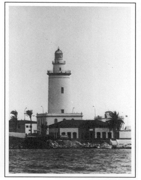 |
Malaga Light |
Caution. – When entering the harbor, vessels should stay well clear of the breakwaters in order to avoid off-lying rubble.
Several submarine cables lie in the approaches to the bay and the harbor and may best be seen on the chart.
Care must be taken to pass well clear of the prohibited area and the terminals situated SE of the harbor entrance.
Several wrecks, some dangerous, lie in the approaches to the port and the offshore terminal and may best be seen on the chart.
2.13 Punta de Velez-Malaga (36°43'N, 4°07'W), low and sandy, is located 9 miles E of Punta de los Cantales. This point is slowly extending seaward as a result of the deposits brought down by the freshets of the Rio de Velez and should not be closely approached. During offshore winds, anchorage can be obtained off the coast between these points.
The mountains, which back this stretch of the coast, attain considerable heights. Some of the loftier peaks and summits are snow-covered for the greater part of the year and are visible from the African coast.
Pico de Zafarraya (37°00'N, 4°04'W), 2,134m high, has a conspicuous summit which terminates in a sharp cone. Torre del Mar (36°44'N, 4°05'W), a small town, is situated 1.3 miles NNE of Punta de Velez-Malaga and is marked by an isolated factory with a conspicuous chimney. It is fronted by a small harbor, with a depth of 2m, used by yachts and fishing craft.
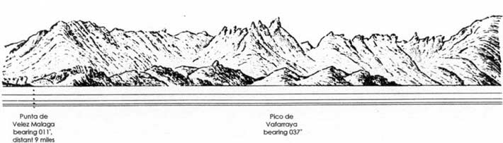
Pico de Zfarraya from SW
Torre del Mar Light is shown from a tower, 26m high, standing 1 mile NE of Punta de Velez-Malaga.
A small craft harbor, protected by breakwaters, fronts the town of La Caleta de Velez, 2 miles NE of Punta de Velez-Malaga. A submarine outfall pipeline extends about 1 mile seaward from a point close E of this town.
Fondeadero de Torre del Mar (36°43'N, 4°07'W), lying off the town, affords good anchorage, during offshore winds, in a depth of 10m, sand and mud. Large vessels, especially in the bad weather season, should anchor, in depths of 18 to 20m, taking care to avoid the numerous marine farms in the area.
2.14 Punta de Torrox (36°44'N, 3°57'W) is low. The land in the vicinity of this point is also low, but gradually rises inland to hills of moderate height. A light is shown from a tower, with a dwelling 23m high, standing on the point.
The Rio Rilamar flows into the sea close E of the point and a coast guard hut stands on its E bank.
Fondeadero de Nerja (36°45'N, 3°52'W) affords anchorage, in depths of 15 to 20m, sand, with a rocky bottom nearby. This roadstead fronts the town of Nerja, which stands 4 miles ENE of Punta de Torrox.
Fondeadero de Herradura (36°44'N, 3°45'W) lies in the bay entered between Punta de Cerro Gordo, located 9 miles E of Punta de Torrox, and Punta de la Mona, 1.5 miles SE. This roadstead affords anchorage, in depths of 10 to 20m, muddy sand, with some rocky bottom, but is reported to be dangerous in winter.
A light is shown from Punta de la Mona and a yacht harbor, protected by breakwaters, is situated close NE of it.
Punta de San Cristobal (36°44'N, 3°42'W), fronted by a reef, is located 2 miles E of Punta de la Mona. The town of Almunecar stands on a hill above this point. A conspicuous church tower and a large hotel, above which are situated the ruins of an ancient castle, stand in the town.
The town of Salobrena (36°45'N, 3°35'W) stands 5 miles E of Almunecar. Two factories, each with a tall chimney, are situated in the town.
Punta del Rio (36°43'N, 3°33'W) is located 2.3 miles SE of Salobrena. This point, which is mostly formed by river sediment, is extending to the S and should be approached with caution. Several prominent oil tanks stand 1 mile NE of the point.
Caution. – Several outfall pipelines are reported to extend up to 0.8 mile seaward from the coast between Punta de Torrox and Punta del Rio.
Several small bights lying between Punta de Torrox and Punta del Rio afford anchorage, but local knowledge is advised.
World Port Index No. 38375
Port of Motril Home Page /http://www.apalmeriamotril.com
2.15 Motril, a small port, lies 1.5 miles NE of Punta del Rio and is protected by two breakwaters.
Depths – Limitations. – The harbor entrance is 130m wide and has a depth of 10m. The main facilities include Levante Quay, 285m long, with a depth of 9.0m alongside; Costa Quay, 298m long, with a depth of 9.0m alongside; and Muelle de Poniente, on the W side of the harbor, 107m long, with a depth of 7.0m alongside. Muelle de Graneles, at the root of Muelle de Poniente and used for handling bulk cargo, is 260m long, with a depth alongside of 10.5m. A dangerous wreck lies close SSE of the head of Muelle de Poniente.
Vessels up to 190m in length and 9.1m draft can be accommodated. There are facilities for ro-ro, general cargo, tanker, and bulk vessels. In addition, a yacht basin is situated in NW part of the harbor.
Aspect. – The prominent city stands in the middle of a plain, 1.5 miles N of the harbor. Several conspicuous oil tanks are situated close W of the harbor.
Pilotage. – Pilotage is compulsory for vessels of more than 500 GT. Pilots can be contacted on VHF channel 12 and board about 1 mile from the entrance. Vessels should send an ETA at least 24 hours in advance and confirm 2 hours before arrival.
Anchorage. – The roadstead situated E of the harbor is shoal and fringed with breakers. Vessels should anchor, in depths of 14 to 15m, mud, about 0.2 mile from the harbor entrance or 1.2 miles S of the head of W breakwater.
2.16 Cabo Sacratif (36°42'N, 3°28'E), which is easily identified, is a rocky headland of moderate height. It is formed by the SW spur of Sierra de Jolucar, which rises to a height 832m about 3.5 miles NE. Two conspicuous radar domes stand on the summit.
A light is shown from a prominent tower, with a dwell-ing 17m high, standing on the summit of the rocky headland. The ruins of Torre del Chucho are situated close to the light. A conspicuous lattice radio mast stands on the summit of a hill 8.2 miles NNE of the light. A dangerous wreck lies 1 mile SW of the light.
Due to a shoal, which extends SE, vessels should stay at least 1 mile clear of the cape.
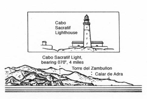 |
Cabo Sacratif |
Ensenada de Calahonda is entered close W of Punta Zambullon, which is located 3.2 miles ENE of Cabo Sacratif. Small vessels up to 100 grt can moor in this bay with their sterns secured to the shore, but local knowledge is essential. Larger vessels can anchor, in depths of 25 to 30m, about 230m offshore.
The town of Gualchos stands at a height of 324m, 2.5 miles NNE of Punta Zambullon. It is situated in a steep-sided ravine, formed like an amphitheater, and is a very conspicuous landmark.
2.17 Punta del Melonar (36°43'N, 3°21'W), a high and steep point, is located 2 miles NE of Punta Zambullon. A light is shown from a tower, 12m high, standing on the point.
The Sierra Nevada extends parallel with the coast and about 20 miles inland as far E as Golfo de Almeria. These mountains are the highest in Spain and are covered with perpetual snow. The most conspicuous summits are Pico Mulahacen (37°05'N, 3°15'W), 3,482m high, and Pico Veleta, 3,392m high, standing 3 miles W of the former. Both of these mountains are visible on clear days from seaward.
The village of Castell de Ferro is situated 0.8 mile NE of Punta del Melonar and is fronted by Fondeadero de Castell de Ferro, which affords anchorage sheltered from NW winds, in depths of 14 to 20m, soft mud. Squalls sometimes blow heavily down the ravines in this vicinity and, as the bottom is steep and the holding ground poor, vessels are liable to drag anchor.
Punta Negra (36°45'N, 3°14'W), surmounted by a ruined tower, is named from the dark color of the land in its vicinity. The village of La Rabita stands on a small plain at the foot of a hill, 2 miles E of the point. A prominent castle is situated on the summit of the hill.
World Port Index No. 38380
2.18 Adra, a small port, lies 9 miles E of Punta Nagra and is protected by two rubble breakwaters and two interior jetties.
Depths – Limitations. – Facilities include a main quay, 140m long, which can handle general cargo vessels up to 2,600 grt and a 5.5m draft, and Levante Quay, 200m long, which can handle fishing vessels up to 4m draft.
Aspect. – A light is shown from a prominent tower, 26m high, standing 1 mile W of the harbor entrance. Torre de los Perdigones stands on a small promontory, close N of the harbor. This tower is an excellent landmark and can be easily identified from the other towers and chimneys in the vicinity. It is shaped like a truncated cone, 40m high, and the lower one-third is white while the upper two-thirds are brick-colored.
Pilotage. – Pilotage is compulsory for vessels of more than 50 grt. Pilots can be contacted by VHF and board vessels about 0.5 mile outside the harbor entrance. Vessels should send an ETA 72 hours, 48 hours, and 24 hours prior to arrival.
Anchorage. – Anchorage can be obtained, in a depth of 14m, sand, about 0.3 mile W of the head of the W breakwater. This anchorage is sheltered from NE and NW winds and the holding ground is mostly good. However, this anchorage is dangerous with onshore winds.
Caution. – Vessels should stay clear of the breakwater heads because of the slope of the rubble of which they are formed. Depths in the port change frequently due to silting; local knowledge is necessary to enter the port.
2.19 Punta de los Banos (36°42'N, 2°51'W) is located 9 miles SE of Adra. A light is shown from a prominent tower, 21m high, standing on the point. The town of Dalias is situated 7.5 miles N of this point and shows up well from seaward against the dark mountainous background. Torre de Aljamilla stands 4 miles E of Adra. Torre de Baler-ma stands in a large village, 2.5 miles SE of Torre de Aljamilla.
Llanos de Almeria, also known as Campo de Dalias, is a low plain which, beginning near Torre de Aljamilla, extends E to the W shore of Golfo de Almeria. Caution is necessary in estimating the distance from the seaward edge of this plain.
Bajo Culo de Perros, a reef, lies about 0.7 mile S of Punta de los Banos and has a least depth of 3.9m.
Almerimar (36°42'N, 2°48'W), an extensive yacht harbor, is situated 2.5 miles E of Punta de los Banos and is protected by breakwaters.
Punta de las Entinas is located 4 miles ESE of Punta de los Banos, and a shoal extends up to 0.5 mile S and SE of it. This point derives its name from several “entinas” or shoals which are formed by seaweed.A dangerous wreck lies 0.8 mile ESE of Punta de las Entinas, with a minimum depth of 2.5m. These shoals, marked by a lighted buoy, grow from the bottom to the surface and are separated by narrow channels. A conspicuous group of buildings, which is reported to be lighted at night, stands 0.7 mile N of the point.
Punta del Sabinal (36°41'N, 2°42'W) is located 3.7 miles E of Punta de las Entinas. A light is shown from a tower with a dwelling, 30m high, standing 0.2 mile N of the actual point. Punta Elena, the W entrance point of Golfo de Almeria, is located 2.5 miles ENE of the point.
2.20 Golfo de Almeria (36°46'N, 2°25'W) lies between Punta Elena and Cabo de Gata, 22 miles E. Its shores are free from off-lying dangers and can be safely approached. The W shore is backed by cliffs and the E shore is low and flat.
Torre de los Cerrillos, which is in ruins, stands close W of Punta Elena and a conspicuous hotel stands in Playa Serena, 2 miles NE of it.
Puerto de Roquetas, a small craft harbor, is situated 4.5 miles NE of Punta Elena. It is protected by breakwaters and has depths of 1 to 3.7m. Castillo de Roquetas, which is in ruins, is situated close S of the harbor and a disused light structure stands close SE of it. Torre de los Bajos, which is in ruins, stands 2.3 miles NNE of the castle.
Anchorage, sheltered from W winds, can be obtained off the coast between the ruins of Castillo de Roquetas and Torre de los Bajos. A good berth lies, in a depth of 30m, sand, 1 mile offshore. Vessels of light draft can anchor, in a depth of 16m, close inshore, about 0.6 mile NE of the castle.
Puerto Deportivo Aguadulce, a marina, is situated 2 miles NE of Torre de los Bajos and is protected by breakwaters.
Sierra de Gador (36°54'N, 2°50'W), a branch of the Sierra Nevada, stands 12 miles NW of the head of the gulf. This range attains heights of over 2,300m and is conspicuous from seaward.
Caution. – Several submarine cables extend seaward from the vicinity of the head of the gulf and may best be seen on the chart.
Several marine farm areas have been established along the shores of the gulf. These extend up to 1.5 miles seaward and may best be seen on the chart.
World Port Index No. 38390
2.21 The port of Almeria lies at the head of Golfo de Almeria and is protected by a main breakwater which extends 1 mile SE.
Port of Almeria Home Page http://www.portel.es/almeria
Tides – Currents. – Tides rise 0.5m at springs and 0.4m at neaps.
Depths – Limitations. – The harbor entrance is dredged to a depth of 14.9m. A channel, with a dredged depth of 12m, leads into the harbor and another, with a dredged depth of 14.4m, leads to the ore berth . A yacht marina is situated in the NW part of the harbor and a fishing vessel basin is situated close W of the root of the breakwater.
The main facilities include Muelle Levante, 350m long, with depths of 8 to 10m alongside; Muelle Ribera, which has 900m of total berthing space with depths 6.5 to 9.5m alongside; Muelle Poniente, which has 855m of total berthing space with depths of 10 to 11.7m alongside; and the CAM ore jetty, which has a depth of 14.4m alongside.
There are facilities for ro-ro, general cargo, passenger, tanker, and bulk vessels. Vessels up to 78,000 dwt, 259m in length, and 13.6m draft have been accommodated.
Aspect. – Alcazaba, a conspicuous citadel, is situated close NW of the city and a monument stands close SE of it. This monument is conspicuous by day and illuminated at night. Several conspicuous buildings and chimneys stand at a power station, 1 mile ESE of the harbor entrance.
Punta del Rio, a level and sandy headland, is located 2 miles SE of the power station. It is formed from the sediment brought down by the Rio Andarax which enters the sea at this point. A lighted buoy is moored about 0.3 mile S of the point and vessels should not attempt to pass to the N of it. A prominent television mast, 20m high, stands close NW of the point.
Punta de Torrejon is located 1.5 miles W of the harbor entrance and is surmounted by Castillo de San Telmo, a coast guard station.
A light is shown from a tower, 7m high, standing on Castillo de San Telmo.
Pilotage. – Pilotage is compulsory. Pilots can be contacted on VHF channels 12 and 16 and board about 1.3 mile SSE of the head of the breakwater. Vessels should send an ETA at least 48 hours in advance.
Anchorage. – Anchorage may be obtained, in depths of 18 to 20m, in Rada de Almeria, about 0.2 mile WSW of the head of the breakwater.
Caution. – A submarine pipeline extends 0.7 mile S from the root of the main breakwater and is marked by a lighted buoy.
2.22 El Cabo de Gata (36°43'N, 2°12'W), located 14 miles SE of Almeria, is a rugged headland at the S end of the Sierra de Gata range. A light is shown from a prominent tower, 19m high, standing on the cape.
A rock, with a least depth of 3.3m, lies about 0.6 mile SSE of the light and vessels should not attempt to pass between it and the cape. Artificial reefs have been established 1 mile NW of the cape and should be given a wide berth . A wave recorder buoy is moored 0.7 mile SW of the light.
Small vessels, with local knowledge, can obtain anchorage, sheltered from E winds, off Playa de Corralete. The best berth lies, in a depth of 10m, sand and weed, about 2.5 miles NW of the cape.
Torre de Vela Blanca stands on a headland, 1 mile E of Cabo de Gata. A conspicuous white patch lies at the foot of this headland and resembles a vessel under sail.
Regulations. – A voluntary IMO-established Traffic Separation Scheme (TSS) with associated VTS has been established off Cabo de Gata. The VTS regulates traffic 5 to 12 miles off-shore, with an associated inshore traffic zone established between the traffic scheme and the coast. Vessels may establish contact with the radio reporting system GATREP on VHF channels 16, 10, and 74 when within 3 miles of entering the TSS. The report should be formatted to include the following information:
| GATREP Information | |
|---|---|
| Designator | Information required |
A |
Vessel’s name, call sign, and IMO number. |
C |
Latitude and longitude |
D |
Position giving distance and bearing from a landmark |
E |
Vessel’s course. |
F |
Vessel’s speed. |
G |
Last port of call. |
H |
Next port of call. |
P |
Dangerous cargo, if applicable. |
Q |
Defects, damages, cargo loss, or incidents leading to pollution. |
R |
Any other circumstances affecting SOLAS and MARPOL conventions. |
The radio reporting system will furnish participating vessels with information relative to conditions affecting navigation to include the presence of vessels restricted in their ability to maneuver, concentrations of fishing vessels relative to the TSS, and meteorological conditions. A continuous listening watch on VHF must be maintained if using the TSS.
2.23 Morron de los Genoveses, a promontory, forms the S end of a cove which is entered 4 miles ENE of Cabo de Gata. This promontory is 69m high and conical, with a somewhat flattened summit. Sheltered anchorage can be obtained, in depths of 8 to 10m, off Puerto Genoves, within this cove; local knowledge is advised.
Monte del Fortin, a promontory surmounted by the ruins of a castle, separates Puerto Genoves from Ensenada de San Jose, a cove on its N side. Anchorage can also be obtained by small vessels, in depths of 10 to 12m, within this cove. A yacht harbor, protected by breakwaters, is situated at the N end of Ensenada de San Jose.
Ensenada de los Escullos lies 3.5 miles NE of Ensenada de San Jose. A prominent castle stands on the shore of this bay. Anchorage, sheltered from W and SW winds, can be obtained anywhere in the bay according to draft. Large vessels can anchor, in a depth of 22m, coarse sand, about 0.5 mile E of the castle.
Los Frailes, two conspicuous peaks, stand at the W side of Ensenada de los Escullos and are excellent landmarks for rounding Cabo de Gata.
2.24 Punta de la Polacra (36°50'N, 2°00'W) is located 12 miles NE of Cabo de Gata. An isolated rock lies close S of the point, and when seen from a distance, appears like a vessel under sail. A light is shown from a tower, 14m high, standing on the point.
Punta de Media Naranja (36°56'N, 1°54'W) is located 7.5 miles NE of Punta de la Polacra. Several small bays lying between these points offer sheltered anchorage to vessels with local knowledge.
La Mesa de Roldan is a high tableland which extends between Punta de Media Naranja and Punta de los Muertos, 1.2 miles NE.
Mesa de Roldan Light is shown from a tower, 18m high, standing on the summit of La Mesa de Roldan, 0.3 mile NNW of Punta de la Media Naranja.
Cala de Agua Amarga, entered 1 mile WSW of Mesa de Roldan Light, affords shelter to small craft from NE winds. A pier extends S from the shore of this bay and several mooring buoys are situated in its vicinity.
Punta Carboneras, surmounted by a castle, is located 3.5 miles NNE of Mesa de Roldan Light. A small island lies on a reef which extends up to about 0.5 mile SE of the point.
Puerto Pesquero, a small fishing harbor, is situated close SW of the point and is protected by a breakwater.
2.25 Puerto de Carboneras (36°58'N, 1°53'W) (World Port Index No. 38395), a small harbor, is situated 1.2 miles S of Punta Carboneras and is protected by a breakwater which extends 0.4 mile E and S. The harbor basin has depths of 7 to 19m and is used by coal vessels. A quay, 241m long, has depths of 15m alongside.
A conspicuous chimney, 200m high, stands near the harbor.
Pilotage is compulsory. Pilots can be contacted on VHF channel 12 or 16 and are available from Garrucha. Pilots board 1 mile off the jetty. Vessels should send their ETA 24 hours and 12 hours in advance.
Anchorage is available NE of the breakwater.
Puerto de Hornos Ibericos (36°59'N, 1°53'W), a small harbor, is situated 0.5 mile S of Puerto de Carboneras. It is protected by a high -angled breakwater and is used by cement and gypsum carriers. Muelle Norte, at the N side of the basin, has a depth of 9m alongside, and Muelle Este, at the E side of the basin, has a depth of 13m alongside. Vessels up to 77,000 dwt, 245m in length, and 14.0m draft have been accommodated.
2.26 Torre del Penon (37°04'N, 1°51'W) stands on a low promontory, 4.5 miles N of Punta Carboneras. Torre de Macenas, formed by a ruined castle, stands 0.6 mile N of Torre del Penon. A coast guard hut is situated near it.
Anchorage can be obtained, in depths of 10 to 25m, sand, about 1 mile N of Torre de Macenas, but this berth is only safe in settled weather.
Sierra Cabrera (37°05'N, 1°56'W) is the highest range on this part of the coast; the peaks are visible from 40 to 45 miles seaward. Mojacar (37°08'N, 1°51'W), a prominent town, stands on the crest of a high hill at the E end of this range.
Puerto de Garrucha (37°10'N, 1°50'W), a small harbor, is situated 11.5 miles NNE of Punta Carboneras and is protected by two breakwaters. A fishing quay is situated on the N side of the harbor and a yacht basin lies at the W side. A quay, situated at the inner side of the breakwater, has depths of 1 to 10m alongside.
The town backs the harbor; a light is shown from a structure, 10m high, standing close S of it. A prominent castle is situated close S of the light structure. Several prominent chimneys also stand in the vicinity of the town.
Pilotage is compulsory. Pilots board 1 mile off the jetty. Vessels should send their ETA 24 hours and 12 hours in advance. During offshore winds, anchorage can be obtained, in depths of 15 to 30m, off the middle of the town.
Punta de Sarria (37°19'N, 1°42'W) is located 9.5 miles NE of Garrucha and several dangerous reefs lie close SE of it. A prominent ruined castle stands on a steep point, 4 miles NE of Punta de Sarria. Isla de los Terreros, 34m high, lies 0.6 mile S of the ruined castle. This island is steep-to and is separated from the mainland by a narrow channel with a depth of 7.5m. Isla Negra, another small island, lies 0.2 mile NE of the ruined castle. It is 25m high and dark, but can be seen easily against the pale cliffs behind it.
During NE winds, anchorage can be obtained by vessels with local knowledge, W of Isla de los Terreros. The best berth lies, in depths of 13 to 14m, mud and weed, about 0.7 mile from the island.
2.27 Aguilas (37°24'N, 1°34'W) (World Port Index No. 38410 ), a small port, is situated in a bay, 8.5 miles NE of Punta de Sarria. The harbor is protected by a breakwater which has a main quay on the inner side. It is 300m long with depths of 8.8 to 9.8m alongside. Vessels up to 160m in length and 9.7m draft can be accommodated. In addition, a jetty for fishing vessels is situated within the harbor and an extensive yacht marina lies on the N side of the bay. Pilotage is compulsory. Pilots can be contacted on VHF channel 16 and board about 1 mile from the entrance.
Monte de las Aguilas, a rocky peninsula, forms the W side of the harbor. It is 70m high, conical in shape, reddish in color, and is easy to identify. The ruins of Castillo de San Juan are situated on the summit of this peninsula. A light is shown from a tower, 23m high, standing close E of the ruins.
Punta de la Aguilica, located 0.6 mile ENE of the light, forms the E side of the bay and is fronted by rocks. Isla de la Aguilica lies close S of this point.
2.28 Hornillo (37°24'N, 1°33'W) (World Port Index No. 38420 ) is situated in a bay on the E side of Punta de la Aguilica. It is an ore-handling installation and considered to be part of the port of Aguilas. Isla del Fraile, 80m high, lies 0.6 mile ENE of the E side of Punta de la Aguilica and forms the E side of the bay. A main pier is situated at the W side of the bay and has depths of 6 to 10m alongside. Vessels up to 160m in length and 8.8m draft can be accommodated alongside. Pilotage is compulsory and available from Aguilas. Anchorage can be obtained, in a depth of 20m, 0.2 mile E of the pier head.
Cala Bardina (37°26'N, 1°31'W) lies 2 miles NE of Hornillo. This bay affords good shelter from E winds to vessels with local knowledge. Anchorage can be obtained, in a depth of 24m, sand and weed, about 200m off the E shore, or, in a depth of 14m, sand and gravel, about 0.2 mile off the beach at the head.
(Mounte Cope) (37°25'N, 1°28'W), a reddish promontory, forms the E side of Cala Bardina. It is 248m high, rocky, and steep-to on the SE side. Vessels can anchor, in a depth of 20m, off the NE side of this promontory.
Golfo de Mazarron lies between Cabo Cope and Cabo Tinoso, 18 miles E.
Punta de Calnegre is located 6 miles NE of Cabo Cope. During offshore winds, anchorage can be obtained, in depths of 11 to 13m, mud, off Playa de Calnegre, on the S side of the point. Anchorage can also be obtained, in depths of 13 to 14m, weed, off Playa de Parazuelos, on the N side of the point.
Sierra Morera (37°35'N, 1°20'W) stands NE of Punta de Calnegre and consists of three main peaks which are visible from a great distance. The two W peaks are the highest and the E peak has a slightly whiter color than the others.
2.29 Rada de Mazarron (37°33'N, 1°13'W) indents the coast 15 miles NE of Cabo Cope. This bay lies between Cabezo del Puerto and Punta de la Azohia, 4 miles E, and has mostly sandy shores.
Mazarron Light is shown from a tower, 11m high, standing on the edge of Cabezo del Puerto.
 |
Approach to Golfo de Mazarron from S |
A small yacht harbor, protected by a breakwater, is situated on the E side of a point, 1 mile WSW of the light.
La Galerica located 0.3 mile N of Mazarron Light, consists of two above-water rocks which are by foul ground.
Cabezo del Puerto has steep sides. It is surmounted by a conspicuous monument, 13m high . A prominent tall building stands 0.8 mile W of this monument. Torre Vieja (Torre de Salinas), 11m high, surmounts a low hill, 0.6 mile N of Cabezo del Puerto.
The town of Mazarron stands along the W shore of the bay NW of Mazarron Light. Numerous prominent villas and hotels are situated in this vicinity.
A small harbor, with depths of 1 to 7m and protected by a breakwater, is located in the vicinity of Cabezo del Puerto
Vessels may anchor, in a depth of 15m, about 0.2 mile NE of Mazarron Light.
Cabezo del Mojon, located 1.5 miles NE of Cabezo del Puerto, is conspicuous because of its dark grey color. Isla Plana, a flat islet, lies 0.8 mile E of this point and is fronted by rocks on the S side. The pylons of a disused mineral transporter are situated 0.8 mile E of this islet.
Punta de la Azohia (37°33'N, 1°10'W) is surmounted by Torre de la Azohia, an octagonal building. Vessels may anchor, in depths of 13 to 14m, sand, about 0.2 mile NW of this point.
2.30 Cabo Tinoso (37°32'N, 1°06'W) is high, precipitous, and reddish in color. A light is shown from a tower, 10m high, standing on the cape.
Caution. – Strong currents, usually E, are reported to be frequently experienced off Cabo Tinoso.
A local magnetic anomaly was reported (1977) to exist about 3 miles S of Cabo Tinoso.
Submarines exercise frequently in an extensive area centered 25 miles S of Cabo Tinoso.
An explosives dumping area, the limits of which are indicated on the chart, lies 7 miles SE of Cabo Tinoso. Depth charge dropping exercises may be carried out within this area.
An unexploded ordnance obstruction area, marked by a buoy, lies about 3.2 miles SE of Cabo Tinoso.
2.31 Cala Salitrona (37°33'N, 1°07'W), a cove, lies 1.2 miles NW of Cabo Tinoso and affords good shelter from winds between the NW and SW. Anchorage may be obtained by small vessels with local knowledge within this cove.
Punta del Moco, a steep headland, is located 3 miles NE of Cabo Tinoso. El Roldan, 495m high, has a conspicuous summit. This mountain rises fairly steeply from the shore, 1.5 miles ENE of the point, and is an excellent landmark.
Isla de Las Palomas, a rocky islet, lies 0.5 mile offshore, 1 mile S of El Roldan. A marine farm has been established 0.3 mile N of Isla de Las Palomas. La Terrosa lies 1 mile ENE of this islet and consists of a rock connected to the shore by a spit of sand.
Caution. – Shoaler depths than charted may exist in the vicinity of Isla de las Palomas and La Terrosa.
Algameca Grande, an indentation, is located 0.7 mile NE of La Terrosa. A small military harbor, protected by a breakwater, lies within this indentation. Algameca Chica, a small cove, lies close E of Algameca Grande and affords anchorage to small craft with local knowledge.
2.32 Punta de la Podadera (37°35'N, 0 °59'W), steep-to and surmounted by a fort, is located on the E side of Algameca Chica. Punta de Trinca-Botijas is located 0.7 mile SE of Punta de la Podadera. It is high, cliffy, and surmounted by two batteries.
Bajo de Santa Ana lies about 100m offshore, 0.3 mile NW of Punta de Trinca-Botijas. This shoal has a least depth of 3.2m and is marked by a lighted buoy.
Bajo de las Losas, marked by a lighted buoy, consists of several flat-topped submerged rocks and lies about 0.3 mile S of Punta de Trinca-Botijas.
Punta del Gate is located 0.3 mile SE of Bajo de las Losas.
Punta de los Aguilones (37°34'N, 0 °58'W), comparatively steep-to, is located 0.9 mile SSE of Punta del Gate. Islote de Escombreras lies 0.2 mile W of Punta de los Aguilones and is steep-to and hilly. A light is shown from a tower, with a dwelling, 8m high, standing on the island.
Bajo de Escombreras lies 0.2 mile W of the W end of Islote de Escombreras. This shoal has a least depth of 8.9m and is marked by a lighted buoy.
World Port Index No. 38430
2.33 The port of Cartagena, a natural harbor, is entered between Punta de la Podadera and Bajo de Santa Ana. It has facilities for commercial shipping and is also a navy base.
Port of Cartagena Home Page http://www.apc.es
 |
Port of Cartagena |
Tides – Currents. – Tides within the harbor are usually negligible. During winds from the S, the water level may rise up to 0.5m. During winds from the N, the level may decrease by the same amount.
Depths – Limitations. – The harbor is protected by two breakwaters. Dique de Navidad extends 150m SE from a point on the W shore of the harbor, 0.3 mile NE of Punta de Podadera. Dique de Curra extends 700m W from a point on the E shore of the harbor, 0.5 mile NE of Bajo de Santa Ana. The entrance to the harbor has a width of 250m and a depth of 12.5m.
Curra Wharf, 762m long, is situated on the N side of Dique de Curra. It has a depth of 11.8m alongside and is mostly used by naval vessels. A small shipyard and a naval basin lie on the W side of the harbor.
The main facilities include Muelle de Alfonso XII (Muelle Comercial), 943m long, with depths of 7.6 to 12.5m alongside; Muelle de Santa Lucia, 375m long, with depths of 8.6 to 12.5m alongside; and Muelle de San Pedro, 440 long, with a depth of 12.1m alongside.
There are facilities for general cargo, container, ro-ro, and fishing vessels.
Aspect. – The harbor is easily recognized by the broken edge of the mountain as it descends towards the port on one side or the other. The city, surrounded by a wall, is situated N of the head of the harbor and is conspicuous. A circular hill, surmounted by the ruins of Castillo de la Concepcion, rises in the S part of the city.
Castillo de Galeras, Castillo de Atalaya, and Castillo de San Julian stand 0.5 mile NW, 1.5 miles NW, and 1 mile E, respect-ively, of Punta de la Podadera. Other prominent landmarks include the light structure on the head of Dique de Navidad; two chimneys, each 100m high, standing 0.5 mile NE of Bajo de Santa Ana; and the military hospital building situated close E of Castillo de la Concepcion.
Pilotage. – Pilotage is compulsory. Vessels should send an ETA 24 hours and 12 hours in advance. Pilots may be contacted on VHF channel 11, 12, 14, or 16 and generally board vessels about 1.2 miles WNW of Islote de Escombreras. Pilots may board large vessels bound for Ensenada de Escombreras about 1.5 miles WNW of Islote de Escombreras.
Anchorage. – Designated anchorages are, as follows:
- For small craft (length of up to 100m):
- Area A – 37°34.7'N, 0 °59.3'W
- Area B – 37°34.6'N, 0 °59.7'W
- Area C – 37°34.0'N, 0 °58.2'W
- Area L – 37°34.3'N, 1°07.0'W
- Area M – 37°33.0'N, 1°07.1'W
- For medium-sized vessels (length between 100 and 200m):
- Area D – 37°34.4'N, 1°00.1'W
- Area E – 37°34.0'N, 1°00.6'W3.
- For VLCC’s and LPG vessels:
- Area F – 37°33.7'N, 1°01.6'W
- Area G – 37°33.3'N, 1°02.5'W
- Area h – 37°32.8'N, 1°03.5'W
- Area I – 37°33.7'N, 1°04.3'W
- Area J – 37°33.4'N, 1°05.3'W
- Area K – 37°33.2'N, 1°06.4'W
Caution. – An anchoring and fishing prohibited area, the limits of which are shown on the chart, lies in the vicinity of Punta de Trinca-Botijas and extends up to 300m W.
Shoaler depths than charted may exist in Darsena de Cartagena.
2.34 Escombreras (37°34'N, 0 °58'W) (World Port Index No. 38425) is situated 1.5 miles SE of Cartagena. It is protected by a breakwater and is a terminal for oil tankers and natural gas vessels.
Depths – Limitations. – The harbor is entered between Punta del Gate and the N end of Dique Muelle Bastarreche, a breakwater, which extends 0.4 mile NE from Punta de los Aguilones.
The main bulk facilities include Principe Felipe Quay, 350m long, with a depth of 16m alongside, and Agribulk Quay, 480m long, with a depth of 14.5m alongside.
In addition, there are eight berths for tankers, with depths of 8 to 26m alongside, and three berths for LPG/LNG vessels.
Tanker vessels up to 250,000 dwt, 360m in length, and 21m draft can be accommodated. Gas vessels up to 240m in length and 14m draft can be accommodated.
Pilotage. – See Cartagena in paragraph 2.33.
Anchorage. – It has been reported (1997) that large tankers awaiting entry to the oil terminal at Ensenada de Escombreras anchor S of Punta de la Podadera. Caution is necessary when transiting the approaches to Cartagena as these tankers will cross the approach to Cartagena en route to the oil terminal.
Caution. – A submarine pipeline extends 0.2 mile WNW from a point on the shore, close W of the root of Dique Muelle Bastarreche.
Shoaler depths than charted may exist in Escombreras, including the charted dredged area, and in Boca Chica.
2.35 Cabo del Agua (37°33'N, 0 °56'W), located 2 miles E of Punta de los Aguilones, is high, rugged, and terminates in three peaks. During strong E winds, heavy squalls occur off this cape and it should be approached with caution.
Cala del Gorguel, a cove, is entered 2.5 miles NE of Cabo del Agua. It affords anchorage to small vessels, sheltered from N winds, in a depth of 12m, sand and mud, midway between the entrance points. A rocky islet lies near the shore, close SW of this cove.
Punta de la Chapa (37°35'N, 0 °51'W) is located 4 miles NE of Cabo del Agua and forms the E side of a small bay. A light is shown from a tower, with a dwelling 8m high, standing on the point. La Bola, a rock, lies 0.2 mile NW of the light and has a least depth of 2.7m. It is marked by a beacon and breaks during onshore winds.
The former small craft harbor of Portman lies in the bay, close NW of the light. Repeated landslides have closed this harbor. A lighted buoy is moored off the former entrance.
Cabo Negrete, located 1 mile E of Punta de la Chapa, is high, rugged, and black in color. Cerre de Sancti Spiritus, 436m high, stands 2.7 miles NW of this cape and is prominent.
Los Juncos are two conspicuous hills which back this part of the coast. Junco Grande (37°36'N, 0 °46'W) is 338m high and the W hill, and El Junquet (37°37'N, 0 °43'W) is 288m high and the E.
Punta de la Espada (37°36'N, 0 °44'W) is located 5.2 miles ENE of Cabo Negrete. Bajo del Descargador, with a least depth of 2.9m, lies 0.2 mile offshore, 0.7 mile NE of this point.
Cala Avellan, a small inlet, lies 2 miles NE of this point. La Barra, a village, is situated at the head of the inlet. It stands on the isthmus that joins the peninsula of Cabo de Palos and contains numerous prominent resort chalets. A small harbor basin, protected by a breakwater, fronts the village and is used by fishing craft and pleasure boats.
Cabo de Palos (37°38'N, 0 °41'W), located 0.5 mile ENE of Cala Avellan, is described in paragraph 3.3.