ITALY – EAST COAST – TESTA DEL GARGANO TO FIUME PO DELTA
(INCLUDING OFFLYING ISLANDS) SECTOR 18
Plan. – This sector describes the coast NE part of the Italian Adriatic coast from Testa del Gargano, at the E side of Promontorio del Gargano, N to Porto Garibaldi in the S approaches of the Fiume Po delta. The off-lying islands of Isola Pianosa, Isole di Tremiti, and Otok Palagruza are also included.
General Remarks
18.1 Regulations. – Tanker vessels of 1,600 grt and over entering or leaving Italian ports and carrying, or with uncleaned tanks which last carried, petroleum, gas, or chemical products should report to a shore station before entering Italian territorial waters off Italian ports. For further details, see Pub. 140, Sailing Directions (Planning Guide) North Atlantic Ocean, Baltic Sea, North Sea, and the Mediterranean Sea.
Caution. – Numerous offshore oil and gas installations and associated pipelines and service craft may be encountered off the coast described in this sector.
The coastlines of Promontorio del Gargano and Isole Tremiti consist of high and rocky sections which stand sheer above the sea with natural caves and grottoes surrounded in places by rocks. Regulations are in force prohibiting the passage and stopping of vessels through areas in these vicinities which are considered dangerous due to rock falls and landslips.
Promontorio del Gargano should be rounded at a distance of at least 1 mile.
18.2 Testa del Gargano (41°50'N, 16°12'E), the NE extremity of Golfe di Manfredonia, is fully described in paragraph 17.22.
Scogliodi Porto Nuovo, a small islet, lies 0.3 mile offshore, 1 mile NNW of Tests del Gargano. It is surrounded by reefs and this area should be given a wide berth.
Isola Santa Eufemia (41°53'N, 16°11'E), an island, lies close ENE of Punta Santa Croce in the approaches to Vieste. An overhead cable, with a vertical clearance of about 20m, spans the channel lying between this island and the point. Vessels with a masthead or rigging height of more than 18m are prohibited from using this passage. A light is shown from a prominent structure, 27m high, standing on the island.
Vieste (41°53'N, 16°11'E), a small town, stands on the slopes around a small bay which is entered between Punta San Francesco and Punta Santa Croce, 0.3 mile NW. A prominent fort, on which is situated a checkered signal station, stands at the SW end of the town. A cathedral, with a high bell tower, stands close E of the fort.
The town is fronted on the N side by a small harbor which is protected by moles. It is mostly used by fishing vessels and is accessible to vessels up to 30m in length and 2.5m draft.The harbor monitors VHF channels 14 and 16. Vessels can anchor, in a depth of 11m, about 0.3 mile E of the S extremity of Isola Sant Eufemia. Large vessels should anchor farther offshore.
Off-lying Islands and Dangers
18.3 Isola Pianosa (42°13'N, 15°45'E) is 3m high and rocky. The N shore of this islet is rather steep-to, but its other shores are fringed by reefs with depths of less than 10m. A light is shown from a structure, 17m high, standing on the N side of the islet.
Isole Tremiti (42°07'N, 15°30'E), a group of four islands, consists of Isola San Domino, Isola San Nicola, Isola Caprara, and Il Cretaccio. These islands are all low by comparison with the mainland.
Isola San Domino, the largest and S of the group, is the most fertile and cultivated island. It has rocky and broken coasts which contain a number of grottoes. The E end of the island is formed by a short yellowish -colored peninsula which terminates in a beach. Punta Secca, the W extremity of the island, is formed by a low, blackish, and narrow peninsula. A hill, 116m high, stands at the S end of the island. A light is shown from a structure, 16m high, standing on the SW extremity of the island.
Isola San Nicola is connected to the E end of Isola San Domino by a reef with a depth of less than 5m. The village of Tremiti contains several buildings including a church and a signal station, and stands at the SW end of the island. It is fronted by a small boat harbor. A light is shown from a structure, 15m high, standing near the N end of the island.
A submerged obstruction, dangerous to navigation, lies about 250m N of the SW extremity of this island and is marked by a buoy.
Il Cretaccio, yellowish and extremely irregular, lies on a reef 0.7 mile NE of the E end of Isola San Domino. This island is the smallest of the group and the passages lying between it and the two larger islands can be used only by shallow-draft craft.
Isola Caprara, the NE island of the group, is separated from the NW side of Isola San Nicola by a narrow passage with a least depth of 8.2m in the fairway. The coasts of this island are rather steep-to and all dangers lie close inshore. A narrow peninsula forms the NE side of the island. A light is shown from a structure standing on this peninsula.
This group of islands affords good shelter from winds between the W and ENE and adequate shelter from bora, strong NE gales. Vessels can anchor, in depths of 31 to 35m, good holding ground, mud, about 0.3 mile off the SE shore of Isola San Domino. Anchorage, in convenient depths, can also be taken SE of the SW part of Isola Caprara.
Otok Palagruza (42°24'N, 16°16'E), a Croatian island, is high, rocky, and rises to a height of 103m near its W end. Above-water rocks, some of which are sharp peaked, lie up to 0.2 mile W of the W end of the island. A light is shown from a structure, 22m high, standing on the SW coast of the island. Another light is shown a tower standing close E of the light.
Otocic Palagruza Mali, 51m high, is connected to the SE end of the above island by shoal ground and is surrounded by rocks and shoals.
Otocic Galijula, 8m high, lies 3 miles ESE of Otok Palagruza and is surrounded by reefs extending up to about 0.5 offshore.
Caution. – Navigation is prohibited within 300m of Otok Palagruza.
Overhead power cables, which may obstruct the passage of vessels with masts, span the channels leading between Isola San Domino and Il Cretaccio, and between Il Cretaccio and Isola San Nicola.
A marine nature reserve area has been reported (1991) to have been established around Isole Tremiti and special regulations apply. The Italian authorities should be contacted for further details.
A Traffic Separation Scheme (TSS) (42°18'N, 16°06'E) lies about midway between Isola Pianosa and Otok Palagruza. This TSS is not IMO-adopted but the national authorities advise that use of this scheme is compulsory for all foreign naval vessels, tankers, nuclear powered vessels, and vessels carrying nuclear or dangerous substances.
18.4 Peschici (41°56'N, 15°53'E), a village, stands 8.5 miles WSW of Vieste. The coast between is indented by sandy beaches and small coves, and surmounted by a number of towers. This village is situated on the top of a barren promontory that appears as a rocky wall descending vertically into the sea. Monte Pucci, standing 1 mile W of the village, is tree-covered and prominent. A small boat harbor fronts the village at the foot of the promontory.
A long wall, with arched openings for the protection of the citrus groves, extends almost from Peschici to Rodi Garganico, 6 miles W, and appears as an arched viaduct.
Rodi Garganico (41°56'N, 15°53'E), a small town, stands on a sloping hill which is surrounded by citrus and olive groves. A conspicuous yellow-colored church cupola is situated in the extreme W part of the town. A mole, 230m long, extends NE from the E part of the town and is for shelter by small craft. Anchorage can be taken, in a depth of 6m, about 0.5 mile N of the head of the mole. Local knowledge is required.
Promontorio di Monte d’Elio (41°55'N, 14°38'E) is formed by a spur from the mountains of the headland of Gargano. Torre Mileto, a prominent structure, and a few white buildings stand on the N point of this promontory. A conspicuous radio mast stands in the middle of the E slope. Lago di Varano and Lago di Lesina lie E and W, respectively, of the promontory. These lakes are separated from the sea by a sandy strip of land which consists of dunes covered by sparse growth.
Between the mouth of Fiume Fortore, located 15 miles W of Torre Mileto, and Termoli, the shore consists of a low, sandy beach, backed by wooded groves. Torre Fantina, a pyramid structure, stands 5.8 miles W of the river mouth and is prominent. A red railway station, with a larger yellow building standing close by, is situated near this tower.
San Martinoin Pensilis, situated 7.5 miles SW of the tower, is recognizable by a prominent steeple standing in the center of the town and by a white reservoir situated nearby.
Anchorage can be taken, in depths of 16 to 18m, sand, N of the mouth of Fiume Fortore and about 1.5 miles offshore.
18.5 Termoli (42°00'N, 15°00'E), a moderate-sized town, is situated on a flat and rocky peninsula, 21m high. The old part of the town stands on the extremity of the peninsula and is enclosed by a prominent wall. The new part of the town stands to the S on a small and flat-topped hill. A light is shown from a structure, 19m high, standing on the fortress at the N end of the town.
Depths – Limitations. – A small harbor lies to the E of the peninsula and is formed by two moles. There are depths of 4 to 4.3m in the entrance and depths of 3 to 3.3m in the center of the harbor. A ferry service operates from here to Isole Tremiti.
Aspect. – Conspicuous landmarks in the vicinity of the town include a low and brown-colored tower standing at the W side of the root of the peninsula; a church with a low campanile; and a cemetery, with several white buildings, standing W of the town and enclosed by a wall.
Numerous modern buildings, some quite large, are situated in the S part of the town.
Pilotage. – Pilotage is compulsory for vessels of 500 gross tons or more. Pilots board 1 mile from the entrance.
Regulations. – The harbor can be contacted on VHF channel 14 or 16 and is accessible to vessels up to 80m in length and 3m draft. Vessels may enter or leave the port during daylight hours only. Before entering the port, and when at least 1 mile from the entrance, vessels should contact the harbor-master on VHF channel 16 for authorization.
Anchorage. – Anchorage for vessels bound for Tremoli or for Rospo Mare Oil Field, 12 miles NNW of Tremoli, is situated within a radius of 0.6 mile of position 42°02.7'N, 15°01.9'E The bottom is sand, good holding ground, but this anchorage is not recommended in N, E, or SE winds.
Caution – A submerged rock, with a depth of 3.4m, lies 270m E of the head of Molo Sud.
18.6 Torre Petacciato (42°01'N, 14°53'E), a square tower, stands on a slope above the beach, 5 miles WNW of Termoli. Anchorage can be taken, in a depth 13m, good holding ground, sand, about 1.5 miles N of this tower.
Between Termoli and Vasto, the coast consists of a low and sandy beach backed by mountains. The coast between Vasto and Punta della Penna, consists of a rocky bluff which is partially covered with olive groves and vineyards and closely bordered by rocks.
Vasto (42°07'N, 14°43'E) (World Port Index No. 40615), a town, stands on a hill and was formerly known as Istonio. Vasto Marina and the surrounding village is situated on the coast and adjacent to the town. Two high and prominent chimneys stand in the S part of the village.
Punta della Penna (42°10'N, 14°43'E) is 23m high, dark, flat-topped, and rocky. A tower and a small building, with a flagstaff close S of it, stand on the point. A light is shown from a prominent structure, 70m high, standing on the point.
Caution. – Several oil production platforms and associated pipelines and mooring buoys are situated within a prohibited area, which may best be seen on the chart, lying 11 miles ENE of Punta della Penna.
18.7 Porto di Vasto (Porto di Punta Penna) (42°10'N, 14°43'E), a small harbor, lies close W of the point and is enclosed by two moles.
Depths – Limitations. – There is 720m of total berthing space, with depths up to 7m alongside.
Vessels up to 165m long, with a draft of 6m, can be accommodated during favorable weather conditions.
Pilotage. – Pilotage is compulsory for vessels of more than 500 gt or more than 60m in length.
The pilot boards 1 mile NE of Punta della Penna Light.
Regulations. – Vessels should provide an ETA 24 hours in advance. Vessels must contact the harbor master on VHF channel 16 before entering port.
Anchorage. – Vessels must anchor within a radius of 0.5 mile of position 42°10.5'N, 14°45.5'E and keeping clear of the wreck lying 2.3 miles ESE of Punta Penne; this anchorage is not recommended during E winds.
The anchorage area has been divided into two zones, as follows:
- Zone A – For cargo vessels not carrying dangerous materials. Vessels must anchor within a radius of 0.5 mile of position 42°10.5'N, 14°45.5'E and keep clear of the wreck lying 2.3 miles ESE of Punta Penne. This anchorage is not recommended during E winds.
- Zone B – For tankers or cargo vessels carrying dangerous cargo. These vessels must anchor within a radius of 0.5 mile of position 42°12.0'N, 14°42.5'E
Caution. – Several production platforms lie in a restricted area, which extends up to 1.5 miles offshore, between Punta della Penna and Punta di Cavalluccio. This area, which may best be seen on the chart, also contains the associated wells and submarine pipelines, and anchoring and fishing are prohibited within it.
18.8 Punta Lotta, located close W of Porto di Vasto, is surmounted by a small and conspicuous pillar. Between this point and Punta di Cavalluccio, 10 miles NW, the sandy coast is intersected by several rivers, the mouths of which are spanned by prominent bridges and viaducts.
Punta di Acquabella (Punta del Moro) (42°20'N, 14°26'E), a rocky point, is located 1.5 miles ESE of Ortona and is pierced by a railway tunnel. San Vito Chietino stands on the top of a hill which slopes steeply to the beach near this point. A conspicuous church, with a surrounding balustraded balcony, stands at the edge of this town and overlooks the sea.
18.9 Ortona (42°21'N, 14°25'E) (World Port Index No. 40620), a small port, lies 1 mile NW of Punta di Acquabella and is formed by two moles. The town, a resort, stands on a small peninsula at the W side of the harbor.
Porto Ortona Home Page http://www.guardiacostiera.it/ortona
Depths – Limitations. – The NW part of the harbor can be entered through a buoyed channel which has a depth of 5.5m. There is 680m of total berthing space for general cargo with a depth of 7.6m. There is 1,530m of total berthing space for general cargo with alongside depths of 5.8 to 7.5m. There is a tanker berth, 160m long, with a depth of 6.1m alongside. There are extensive facilities for yachts and fishing vessels.
Vessels up to 200m in length can be accommodated. The maximum draft allowed is 6.5m in daylight and 6.3m at night.
Aspect. – The S part of the town stands behind an arched retaining wall. The cathedral, with a prominent cupola, stands in the N part of the town. A church, with a prominent belfry, stands 0.5 mile S of the cathedral. A prominent chimney stands in a small valley close SE of the town. A light is shown from a tower, 24m high, standing near the root of the N mole.
A conspicuous reddish -colored bridge, with five arches, crosses the mouth of Fiume Arielli, 3 miles NW of the harbor.
Pilotage. – Pilotage is not compulsory except during poor visibility and sea conditions but is available and is recommended for large vessels. The harbor may be contacted on VHF channel 15 or 16.
Anchorage. – Vessels anchor within a radius of 0.7 mile of position 42°22.5'N, 14°26.5'E as shown on the chart. The holding ground is good, but the anchorage is dangerous during W winds.
Caution. – Vessels are cautioned to give the mole heads a wide berth as depths are noticeably reduced near them.
The entrance and approach channels are subject to shoaling due to the presence of a sandy bar.
A marine farm, marked by lighted buoys, is located 4.5 NE of Ortona and is best seen on the chart.
Ortona to San Benedetto del Tronto
18.10 Pescara (42°28'N, 14°13'W) (World Port Index No. 40630), a small port, lies at the mouth of Fiume Pescara, 10.5 miles NW of Ortona. The small harbor is entered between two moles which project from each side of the river mouth.
Depths – Limitations. – The banks of the river, close inside the moles, are quayed and used by shallow-draft vessels. There is 300m of total berthing space with a depth of 5.2m alongside. Vessels up to 100m in length and 5m draft have allowed to enter the harbor.
Aspect. – Pescara consists of two parts. Pescara-Porto Nuova, consisting of numerous factories and white buildings, is situated on the SE bank of the river. Pescara-Riviera di Castellamare is situated on the NW bank of the river and extends along the shore. It consists of numerous residential buildings and two prominent government buildings. The two parts of the town are connected by bridges.
A prominent radio mast, 130m high, stands 2 miles SSE of the harbor. A conspicuous steel monument, floodlit at night, stands 0.5 mile SSE of the harbor. The light is shown from one of several silos, 30m high, which stand near the root of the N mole.
The conspicuous town of San Silvestro stands on the flat summit of a hill, 1.9 miles SSE of the harbor.
Pilotage. – Pilotage is compulsory for tankers with cargoes of benzene, gasoline, or petrol. For other vessels, pilotage is not compulsory, but is advisable. Pilots may be contacted on VHF channel 12. Berthing within the river is carried out by harbor berthing officers whose services are compulsory for vessels of over 500 grt.
Regulations. – Vessels carrying polluting or dangerous cargo must report to the harbormaster 24 hours in advance.
Anchorage. – Vessels with drafts of 4m or over can anchor between 0.3 and 0.8 mile NNE of the heads of the moles and discharge their cargoes into barges. Larger vessels can anchor, in depths of 11 to 15m, mud, about 2 miles E of the entrance.
Two anchorage zones have been established, as follows:
- Zone A, for vessels not carrying dangerous cargo, has a radius of 0.5 mile centered at on position 42°30.0'N, 14°15.0'E
- Zone B, for vessels carrying dangerous cargo, has a radius of 0.5 mile and is centered on position 42°29.2N, 14°16.4E.
Caution. – The harbor is difficult to enter with NE winds. The entrance is liable to silt and requires constant dredging.
18.11 Silvi (42°34'N, 14°06'E), a prominent town, stands on the crest of a hill, 240m high. Torre di Cerrano stands near the coast, 1.2 miles N of the town. It consists of a embattled building with a set-back addition on the top.
Fiume Vomano flows into the sea through a broad fertile valley, 14 miles NNW of Pescara. This river is spanned near its mouth by a long bridge with 19 arches, and several submarine pipelines are landed in this vicinity.
Caution. – Oil and gas production platforms and associated pipelines lie up to 20 miles seaward of the coast between Pescara and Giulianova and may best be seen on the chart; navigation, anchoring, and fishing are prohibited in their vicinity.
18.12 Giulianova (42°45'N, 13°58'E) (World Port Index No. 40640), a small harbor, lies 6.7 miles NNW of Fiume Vomano and is enclosed by two moles. The town stands partly on the side of a hill, 61m high, and partly extends along the shore. A prominent viaduct, with thirty arches, is situated 1 mile N of the town.
Porto Giulianova Home Page http://www.guardiacostiera.it/giulianova
The harbor is subject to silting. It has a depth of 4m and is mostly used by small craft, fishing boats, and yachts. The port monitors VHF channel 16.
An anchorage area lies 4 miles E of the port.
Caution. – A marine farm, marked by a lighted buoy, is located about 3 miles NE of the town.
A mussel farm, marked by unlighted and lighted buoys, is located close N of the beacon marking the outfall about 2.5 miles NE of Gulianova harbor.
18.13 Fiume Tronto (42°54'N, 13°55'E) enters the sea close N of a village, 8.7 miles NNW of Giulianova. An outfall pipeline extends 2 miles ENE from the vicinity of the river mouth. A wreck, with a depth of 3m, lies about 0.5 mile ENE of the river mouth. A prominent church, 41m high, stands in the village.
Colonnella, a prominent town, stands on the top of a hill, 303m high, 2.6 miles SW of the river mouth. It is situated on the S side of the broad valley through which Fiume Tronto flows.
Caution. – A fish haven, marked by a lighted buoy, is located about 3.7 miles SSE of the mouth of the river.
18.14 San Benedetto del Tronto (42°57'N, 13°53'E), a small port, lies 3.7 miles NNW of Fiume Tronto and is formed by two moles. The town is a fishing center and tourist resort.
Depths – Limitations. – There are depths of 4.6m in the entrance and 3m to 5.5m in the N part of the harbor. The S part of the harbor is shoal. The port may be contacted on VHF channel 11 or 16 and is mostly used by fishing vessels and yachts. Vessels up to 80m in length and 4.5m draft can be handled.
Aspect. – Numerous villas and resort camps line the coast near the town. The belfry of the cathedral situated in the town and a water tank standing near the root of the N mole are prominent. A large black cross stands on a small hill, 1 mile SW of the town. A light is shown from a structure, 31m high, standing near the root of the S mole.
Pilotage. – Pilotage is not compulsory. Vessels should send requests on VHF channel 16 to the harbor master.
Anchorage. – Vessels can anchor, in depths of 10 to 12m, good holding ground, sand, between 0.8 and 1 mile seaward of the harbor, but this anchorage is dangerous with winds from the NE quadrant.
San Benedetto del Tronto to Porto di Ancona
18.15 Torrente Tesino (42°59'N, 13°52'E) flows out through a broad fertile valley, 1.5 miles NNW of San Benedetto del Tronto. The river mouth is spanned by a large and prominent bridge with five arches. Two tall and cylindrical water filters stand near this bridge.
Ripatransone, 508m high, stands 5 miles WNW of the river mouth and is prominent. This hill is surmounted by three towers which from the SE appear level, but from the NE appear uneven.
Pedaso, a village, stands amongst trees on the S bank of Fiume Aso, 7.2 miles NNW of Torrente Testino. The river mouth is crossed by a masonry bridge with six arches. A light is shown from a structure, 22m high, standing on a hillside, 0.7 mile S of the village.
Porto San Giorgio, a small town, stands 6 miles NNW of Pedaso and is a popular resort. Numerous various-colored villas stand along the beach near the town. Prominent landmarks include a fort, a square tower, several chimneys, and a large blue-colored building. A small harbor lies 0.5 mile S of the town and is used by yachts and fishing boats.
The town of Fermo stands on a partially wooded hill, 319m high, 3.5 miles inland of Porto San Giorgio and is conspicuous above the surrounding hills.
Caution. – Numerous oil and gas production platforms, well heads, submarine pipelines, and associated structures lie offshore between San Benedetto del Tronto and Ancona.
18.16 Porto Civitanova (43°19'N, 13°44'E), a small harbor, lies 8.3 miles NNW of Porto San Giorgio and is formed by two moles. It has depths of 3 to 5m and extensive facilities for fishing vessels and yachts. The maximum recommended entry draft is 3m. Vessels can anchor, in a depth of 10m, sand, about 1 mile offshore, but it is dangerous to anchor here with winds from the NE or SE.
The town stands on a hill, 155m high, and can be identified by three conspicuous campaniles and a square tower. Other prominent landmarks include a large palace, a water tank, and a tall chimney. A light is shown from a tower, 46m high, standing in the town.
Monte San Vicino, with a trapezoidal-shaped peak, stands about 30 miles W of the town and is one of the best landmarks along this stretch of coast.
Porto Recanati (43°26'N, 13°40'E), a prominent town, stands at the foot of a hill between the railway and the sea. An ancient tower, a tall chimney, a cement works, a palace, and a high -rise building are situated in the S part of the town and are prominent. A pier, 50m long, fronts the town. Vessels usually anchor about 0.4 mile off this pier in convenient depths.
The town of Loreto, with a prominent campanile, stands on a hill, 127m, high, close W of Recanati.
Caution. – Due to the existence of submarine cables, an anchoring and fishing prohibited area, which may best be seen on the chart, extends up to 6 miles NE from a point on the coast 2 miles N of Porto Recanti.
Several wrecks, some dangerous, lie off this stretch of coast and may best be seen on the chart.
18.17 Punta Mezaluna (43°33'N, 13°38'E) is the E extremity of a prominent headland which rises steeply to Monte Conero, 572m high. It has bare and whitish -colored sides, particularly the E side. The headland is surmounted by a conspicuous disused signal station and an abandoned convent is situated at a lower height, 0.5 mile SE. Two conical rocks lie close E of the point and are prominent from the SE and NW.
A range of prominent hills extends NW from Monte Conero. The village of Numana stands 2.1 miles S of Punta Mezaluna and is fronted by a small yacht harbor. Between Porto Recanati and Numana, the large valley of Fiume Musone slopes into the sea. The latter village is divided into two parts by a small point of land on which stands a tower resembling an isolated arch.
Porto Nuovo is a slightly indented and sandy bay which lies between the headland of Monte Conero and Promontorio di Ancona. A square tower stands on the SE entrance point of this bay which is closely fronted by two detached groups of rocks. Several lighted buoys are moored up to 0.5 mile NE of the tower and mark a fish breeding and obstruction area. Scogliera I Trave, a rocky ledge, forms the NW entrance point of the bay. It extends about 0.6 mile ESE from the coast and forms a natural breakwater. Vessels can find good anchorage, sheltered from S winds, in the SE part of the bay; local knowledge is advised.
Promontorio di Ancona (43°38'N, 13°31'E), located 4 miles NW of the N entrance point of Porto Nuovo, is a headland which extends N from the general trend of the coast
Caution. – Landslides may occur along the coast between Numana and Ancona. Prohibited areas, which may extend 100m from the coast, may be established as necessary.
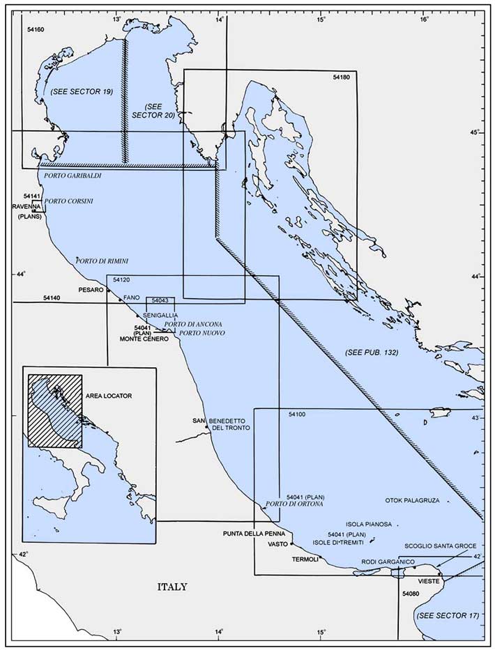
Porto di Ancona (43°37'N, 13°30'E)
World Port Index No. 40660
18.18 The port of Ancona is formed by a dredged harbor which is protected by breakwaters. It is extensively quayed and a small shipyard occupies an area in the N part.
Porto di Ancona Home Page http://www.autoritaportuale.ancona.it
Tides – Currents. – The tidal rise is slight, being only 0.5m at springs. The bora, a strong NE to N wind, has been reported to increase the height of the water level by as much as 0.9m at times.
Depths – Limitations. – The approach channel is dredged to a depth of 13.7m, although the port and its approaches are subject to continuous shoaling. The port has 3,204m of total quayage with berths of 80 to 295m in length and depths of 7.6 to 12.2m alongside. There are facilities for general cargo, roro, passenger, bulk, and container vessels. Vessels up to 250m in length and 12.2m draft can be accommodated.
Aspect. – The city, particularly from the NW, appears to be built on sloping land in the form of an amphitheater below three hills. Monte Guasco stands to the N of the city and a domed cathedral, with a detached campanile, is situated on it; Colle dei Cappuccini stands close SE of Monte Guasco and a disused signal station is situated on it; Monte Astagno stands 0.7 mile S of Monte Guasco and a large citadel is situated on it.
The lights along the coastal road, which connects the city with Falconara Marittima, 5.5 miles W, are very conspicuous. Several prominent silos stand on the S breakwater; a conspicuous crane is situated at the shipyard.
A light is shown from a structure, 15m high, standing on the summit of Colle dei Cappuccini. A racon is situated at the head of the N breakwater.
 |
|
Porto di Ancona |
Pilotage. – Pilotage is compulsory for vessels over 500 grt. Pilots may be contacted on VHF channel 12 or 16 and board about 1.0 mile NNE of the harbor. Pilots are also provided to the oil terminals off Falconara Marittima.
Anchorage. – Vessels can anchor, in depths of 13 to 15m, hard sand, fair holding ground, about 1.3 miles NNE of the N breakwater. Vessels can also anchor, in a depth of 8m, about 0.5 mile SW of the head of the central breakwater.
Designated anchorage areas are obligatory and are, as follows:
- Zone 1SC – Small cargo vessels less than 100m long and with a maximum draft of 6.1m.
- Zone 2SC – Cargo vessels less than 190m long and with a maximum draft of 9.1m.
- Zone 3BC – Cargo vessels greater than 190m long and with a maximum draft of 9.1m.
- Zone 4ST – Small tankers waiting to berth at Pontile A.P.I. at Falconara Marittima.
- Zone 5T – Tankers bound for Isola Vecchia A.P.I. oil berth at off Falconara Marittima.
- Zone 6T – Tankers bound for the A.P.I. Sea Berth SPM off Falconara Marittima.
Caution. – A Traffic Separation Scheme is established in the
approaches to Ancona and Falconara Marittima. The scheme is not IMO adopted, however it is compulsory and Rule 10 of The International Regulations for Preventing Collisions at Sea (1972) applies. Mariners navigating in the traffic lanes between May 1 and September 30 must not exceed a speed of 12 knots.Extreme caution should be exercised in the area at which the inshore traffic zone, which is 1.5 miles wide and runs parallel to the coast, crosses the traffic separation scheme.
Due to the danger from obstructions and explosive ordnance on the sea bed, anchoring and fishing prohibited areas, the limits of which are shown on the chart, lie centered 9 miles NE and 10 miles NW of Ancona.
A detached breakwater is reported (2003) under construction W of the harbor entrance.
18.19 Falconara Marittima (43°38'N, 13°24'E) extends from the sea to the top of a hill facing the beach. A conspicuous long building, surrounded by small houses, surmounts the hill. A prominent white railway station, a red church, and a tall campanile stand in this town near the foot of the hill. Two conspicuous white roads descend from the hill and straddle the town, one leading to the E and the other leading to the W. A conspicuous oil refinery stands close NW of the town.
API Oil Terminal (43°38'N, 13°23'E) lies close NW of Falconara Marittima and consists of a pier, an island berth, and an outer sea berth. It is a sub-port of Ancona.
The pier extends 0.6 mile NE from the shore in the vicinity of the refinery. It has three berths and can accommodate tankers up to 11,000 dwt and 8.2m draft.
The island berth lies 1.4 miles NNE of the head of the refinery pier and is connected to the refinery by a submarine pipeline. It consists of a lighted platform, 11.5m high and 19m in diameter, with several mooring dolphins. Tankers up to 90,000 dwt and 12.1m draft can be accommodated.
The sea berth lies 8 miles NE of the head of the refinery pier and is connected to the refinery by a submarine pipeline. It consists of a lighted steel platform which stands in a depth of 33m and can accommodate tankers up to 300,000 dwt and 30.5m draft.
Pilotage. – Pilotage is compulsory for vessels over 500 grt. Pilots may be contacted on VHF channel 10, 12, or 16 and are provided from Ancona. Vessels should send ETA messages 72 hours, 48 hours, and 24 hours prior to arrival. Vessels should contact the pilot for an anchor berth.
Anchorage. – Designated anchorage areas are, as follows:
- Zone 4ST – Small tankers berthing at the API Oil Terminal.
- Zone 5T – Tankers bound for the Isola Vecchia oil berth at the API Oil Terminal.
- Zone 6T – Tankers bound for the outer sea berth of the API Oil Terminal.
Caution. – At times, strong currents in the vicinity of the refinery pier have made it impossible for vessels to berth or leave. Dangerous wrecks lies about 1 mile ENE and 2.2 miles N of the head of the refinery pier. The submarine pipelines in the vicinity of the terminal berths are marked by buoys. Anchoring and fishing prohibited areas lie in the vicinity of the terminal berths and may best be seen on the chart.
18.20 Fiume Esino (43°39'N, 13°22'E) discharges through a valley and its mouth is spanned by a large bridge with many arches. Montignano, a town, is situated 4 miles WNW of the river mouth and stands prominently on a hill, 99m high. Torre Albani stands on a hill, 112m high, close NW of the town and is prominent.
Senigallia (43°43'N, 13°13'E) (World Port Index No. 40670), a tourist resort, lies at the mouth of Fiume Misa. A large bright-colored bathing pavilion stands close SE of the town and serves as a good landmark. The conspicuous red belfry of the municipal building in the town also serves as a good landmark. It is clearly distinct from the other campaniles and towers by its quadrangular shape, cupola, large windows, and balusters of white marble. A small harbor fronts the town and is protected by two moles. Two high and conspicuous chimneys stand close NW of the harbor which is subject to violent rises of the river. A light is shown from a structure, 17m high, standing near the root of the E mole. The harbor has a depth of 3m and is mostly used by fishing vessels, yachts, and small craft. The port monitors VHF channels 11 and 16. Vessels can anchor, in a depth of 9m, sand, NE of the mole heads, but it is dangerous to remain here with winds from the NE.
Monti di Catria, 1,702m high, stands 27 miles SW of Senigallia. This mountain has a sinuous dorsal ridge and is very prominent in clear weather from seaward.
Caution. – A prohibited area, which may best be seen on the chart, lies about 1 mile offshore, centered 1.4 miles NNW of Senigallia.
Between Senigallia and Fano, the coast consists of a series of hills which are densely covered with vegetation and interspersed with small villages. Fiume Cesano, located 2.7 miles NW of Senigallia, is spanned at its mouth by a bridge with 14 arches. Fiume Metauro, located 9.8 miles NW of Senigallia, is spanned by two prominent bridges. The seaward bridge has 18 arches; the inner bridge has large and conspicuous white pilings.
18.21 Fano (43°51'N, 13°01'E) (World Port Index No. 40680), having the aspect of a large city from seaward, stands at the mouth of Canale Albani, a canal, which is formed by the N branch of Fiume Metauro.
Monte Giove, 223m high, stands SW of the town and is dominated by a convent with a prominent campanile. A high reservoir, with a trellis, is situated in the SE part of the town. Other prominent landmarks include a white pavilion standing near the beach at the NW side of the town; a brown fort situated near the center of the town; a church, with a high belfry, situated in the town; and the silos of the sugar refinery.
The town is fronted by a small harbor formed by moles which extend from the sides of the canal entrance. A swing bridge crosses the canal about 0.2 mile S of the entrance. A light is shown from a structure, 20m high, stands near the root of the inner mole.
The harbor is subject to silting. It has a depth of 3m and is mostly used by fishing vessels, yachts, and small craft. The port monitors VHF channels 14 and 16. Vessels can anchor, in a depth of 11m, mud, about 1.5 miles offshore.
Between Fano and Pesaro, the coast is relatively high and is dominated by Monte Giove and Monte Novilara, 236m high. The latter, standing WNW of Fano, is surmounted by a dark-colored village with a prominent tower.
Monte Ardizio, 149m high, rises close to the coast, SE of Pesaro. This mountain is dark, steep-sided, and slopes steeply to the sea.
Caution. – Numerous oil and gas production platforms, well heads, submarine pipelines, and associated structures lie up to 35 miles offshore between Ancona and Pesaro and may best be seen on the chart.
18.22 Pesaro (43°55'N, 12°54'E) (World Port Index No. 40690), a small port, lies at the mouth of Fiume Foglia and is formed by two moles.
Depths – Limitations. – The harbor has 580m of total berthing space with depths of 2 to 4m alongside. Several rocks, with depths of less than 1.8m, lie on shoals which extend up to about 400m off the harbor entrance. Vessels, with local knowledge, up to 4,000 dwt, 90m in length, and 3.4m draft can enter the harbor.
Aspect. – A church cupola, in the center of the town, and a pavilion, on the beach in the SE part of the town, are prominent. A light is shown from a structure, 25m high, standing on Monte San Bartolo, which rises 1 mile NW of the town.
Pilotage. – The port can be contacted on VHF channel 15 or 16. Local pilots are available. Pilotage is temporarily compulsory for vessels exceeding 400 grt.
Anchorage. – Five anchorage berths have been established, as follows:
- Anchorage A – Lightering operations.
- Anchorage B – Vessels carrying dangerous cargo.
- Anchorage D – Vessels carrying general cargo.
- Anchorage E – Vessels carrying general cargo.
Caution. – Vessels entering or leaving the harbor should not proceed at a speed greater than 5 knots, except under special circumstances.
Vessels mooring alongside the quays are cautioned that parts of the old quay wall still lie submerged adjacent to the new walls.
The harbor is subject to silting.
An anchoring and fishing prohibited area, which may best be seen on the chart, lies up to 2 miles offshore between Fano and Pesaro. A prohibited area, marked by a lighted buoy, is located within the anchorage and fishing prohibited area.
18.23 Cattolica (43°58'N, 12°45'E), a small town, is fronted by a small and shallow harbor which is protected by two moles. Several rocks, with depths of less than 1.8m, lie about 0.2 mile E of the channel leading to the entrance. The harbor is used by fishing boats, yachts, and pleasure craft. A light is shown from a structure, 17m high, standing near the root of the E mole.
A church, with a prominent pointed belfry, stands in the center of the town and two chimneys are situated near the harbor. Numerous conspicuous hotels stand along the beach to the W of the harbor. Gabicce, a village, is situated on a hill, 144m high, standing 1 mile E of the town.
Caution. – Several prohibited areas lie up to 1.5 miles offshore between Pesaro and Cattolica. They are marked by lighted buoys and may best be seen on the chart.
18.24 Riccione (44°00'N, 12°40'E), a sprawling village, lies 5 miles NW of Cattolica and is fronted by a small craft harbor which is formed by two moles. The village has a tree-hidden part and another part comprised of beach villas. A large hotel stands 0.5 mile SE of the harbor entrance and is conspicuous. A tall and isolated chimney stands near the harbor entrance.
Porto di Rimini (44°04'N, 12°35'E), small harbor, consists of the quayed banks of Fiume Marecchia and is entered between two moles which extend N from the shore. The city of Rimini, a resort, stands on the SE bank of the river at the foot of some wooded hills.
The harbor has depths of 2.9 to 3.7m and is subject to silting. It may be contacted on VHF channel 11 or 16 and is used mostly by small craft, pleasure craft, small ferries, and yachts. Vessels with a maximum draft of 3.2m can be accommodated. Vessels can anchor, in a depth of 8m, about 1 mile NNE of the head of the E mole, but this anchorage is not recommended in strong winds which cause a heavy swell. The harbormaster must be contacted on VHF channel 16 for permission to anchor.
Monti di Carpegna, 1,415m high with a flat summit, stands 20 miles SW of the harbor entrance. Monte San Marino, 741m high, stands 9 miles SW of the city and can be distinguished by the three towers which are situated on its summit. Rocca delle Caminate, 330m high and marked by an aviation light, stands 25 miles W of the city and serves as a good landmark for vessels approaching from the N.
A light is shown from a structure, 25m high, standing on the E side of the harbor. This light structure is reported to be difficult to identify during the day. A prominent high -rise building stands 0.5 mile S of the light structure and serves as a good landmark.
Viserba, a sprawling village, is situated close NW of Rimini and extends along a beach protected by moles. It consists of many small villas. A water tank, standing 1 mile NW of the village, serves as a prominent landmark.
Caution. – Several prohibited areas lie up to 4 miles offshore between Cattolica and Rimini. They are marked by lighted buoys and may best be seen on the chart.
Numerous oil and gas production platforms, well heads, submarine pipelines, and associated structures lie up to 15 miles offshore between Pesaro and Porto Corsini and may best be seen on the chart.
18.25 Bellaria (44°09'N, 12°28'E), a large village and resort, is situated at the mouth and close N of Fiume Uso, the Rubicon of Roman history. Numerous conspicuous hotels, villas, and bell towers serve to identify the village. A small harbor, with shallow depths, lies in the river entrance between two short moles and is used by small craft and yachts.
A large cylindrical tank, 47m high, stands in the center of the town and serves as a prominent landmark. A white skyscraper, 124m high, is situated 0.5 mile S of the harbor entrance and is conspicuous. A light is shown from a structure, 17m high, standing 0.2 mile SW of the head of the E mole. This light structure is reported to be obscured by several other buildings.
Port di Cesenatico (44°12'N, 12°24'E) (World Port Index No. 40710) a small harbor, lies 4 miles NW of Bellaria and is protected by two moles. It has depths of 3 to 4.5m and is mostly used by fishing vessels with local knowledge; a maximum draft of 3.4m can be accommodated. Small vessels can anchor, in convenient depths, mud and sand, good holding ground, off the harbor.
Caution. – Numerous oil and gas production platforms, well heads, submarine pipelines, and associated structures lie offshore between Cesenatico and Corsini and may best be seen on the chart.
A flood defense barrier has been established in the entrance to Cesenatico. Transit is subject to system operations using the traffic signals visible for both entrance and exit. Contact the port authorities for details of the signal system.
18.26 Cervia (44°16'N, 12°21'E), a noted resort, stands at the S end of an extensive pine forest. The main industry here is the extraction of salt from the neighboring marshes. A small harbor, with shallow depths, lies close NE of the town and is entered between two moles. The port monitors VHF channels 14 and 16. Anchorage can be taken in convenient depths, mud, good holding ground, NE of the harbor.
The bell tower of the cathedral and a large four-story hotel, with a prominent terrace, are situated in the town and serve as good landmarks. A conspicuous skyscraper building stands on the N side of the town. A light is shown from a structure, 16m high, standing on the S side of the harbor.
Between Cervia and Porto Corsini, 14 miles NNW, the coast is low, sandy, interspersed with marshes, and backed by the pine forests. Several rivers flow out into the sea along this stretch of coast and two of these form projections of land at their mouths. Deposits from these rivers form a bordering shoal, with depths of less than 5.5m, which extends up to about 1 mile offshore.
Caution. – Numerous oil and gas production platforms, well heads, submarine pipelines, and associated structures lie offshore between Cervia and Corsini and may best be seen on the chart.
Porto Corsini (44°30'N, 12°17'E)
World Port Index No. 40720
18.27 The port of Corsini (Ravenna) is linked to Ravenna by Canale di Ravenna. The outer entrance of the port lies between two breakwaters which extend up to 1.5 miles in a general E direction from the shore.
Porto Corsini Home Page http://www.port.ravenna.it
Winds – Weather. – The prevailing winds are from NE to SE and may be very strong at times. Dense fog may occur mainly from September to March.
Tides – Currents. – The tidal rise is small, normally only 0.6m at springs and 0.5m at neaps.
Depths – Limitations. – A dredged channel, about 100m wide, leads WSW into the port and between two inner moles. Canale Baiona, the shores of which are quayed and which is navigable for only a short distance, leads W as a continuation of the entrance channel. Canale di Ravenna leads SW for about 3 miles to Largo San Vitale and its banks are quayed in places. Largo San Vitale forms the new commercial harbor. Canale di Ravenna narrows and trends 2 miles SW from this harbor to Darsena di Ravenna, a quayed basin, which is 550m long and 200m wide.
The outer harbor channel has been dredged to a depth of 10m. The inner harbor channel has been dredged to a depth of 9m over a width of 60m from the head of the inner mole to Largo San Vitale. The remaining part of the channel between Largo San Vitale and Darsena di Ravenna narrows and has a least depth of 5.3m.
The maximum draft allowed from the port entrance to Largo San Vitale is 8.5m and then to Darsena di Ravenna is 5.3m, depending on the beam of the vessel.
The port has 8,000m of total berthing space with depths of 5.5 to 9.4m alongside. There are facilities for general cargo, roro, container, bulk, chemical, LPG, and tanker vessels. Vessels up to 245m in length, 33m beam, and 8.5m draft can be accommodated in the port.
In addition, there are four offshore oil terminal berths which extend up to 9 miles ESE of the port entrance. Three of these terminals consist of platform and mooring buoy berths and can handle tankers up to 100,000 dwt and 13.4m draft. One terminal consists of an SPM and can handle tankers up to 400,000 dwt and 21.3m draft.
Aspect. – The domes and towers of the churches in the vicinity of the city can be seen amidst the surrounding trees from a distance of 8 miles. A light is shown from a structure, 33m high, standing near the root of the S inner breakwater. A signal station is situated close to light.
A conspicuous skyscraper building stands 0.3 mile S of the light; several prominent cooling towers and chimneys are situated at a power station, 0.8 mile WSW of the light.
Racons are situated at the offshore terminals in the approaches to the port and may best be seen on the chart.
Pilotage. – Pilotage is compulsory for vessels with a draft greater than 4.2m and for vessels of 500 grt and over, as follows:
- When entering and leaving the port, commencing and concluding at 1 mile from the head of the outer breakwaters.
- 2. During movements carried out within the port.
- During the mooring stage at working positions within the roads, commencing at least 0.5 mile from the working position to which the vessel is bound.
Pilots can be contacted on VHF channel 12 or 16 and board about 2 miles off the port entrance or between 0.5 and 1 mile off the offshore petroleum terminal berths.
Regulations. – Vessels should send an ETA 72 hours in advance. Tankers bound for the offshore terminals should send an ETA at least 36 hours in advance.
Vessels that must transit the floating swing bridge should call on VHF channel 12 to request opening the bridge. A Traffic Monitoring Service is established and is available on VHF channel 9.
Caution. – In addition to the offshore oil terminal berths, numerous oil and gas production platforms, well heads, submarine pipelines, and associated structures lie up to 15 miles offshore in the approaches to the port.
Several anchoring, stopping, and fishing prohibited areas lie in the approaches to the port may best be seen on the chart.
Several navigation restricted areas lie in the approaches to the port and may best be seen on the chart.
Porto Garibaldi to Fiume Po Delta
18.28 Porto Garibaldi (44°41'N, 12°15'E) (World Port Index No. 40730), a small harbor, lies 11.4 miles N of Porto Corsini and 8 miles SW of the Fiume Po delta. This harbor is entered at the mouth of Canale Pallotta and is protected by moles. It has depths of 3.6 to 3.9m and is mostly used by fishing vessels, yachts, and small craft. The entrance channel, about 40m wide, is subject to silting and leads between sand banks which reduce the navigable fairway to a width of about 25m. The port monitors VHF channels 11 and 16. Vessels can anchor, in a depth of 9m, about 2.5 miles off the harbor.
The village of Comacchio is situated on the canal, amidst salt marshes, 3 miles WNW of the harbor. Two prominent belfries and two prominent towers stand in the village. The isolated campanile of Pomposa, on Fiume Po di Volano, stands 5 miles NW of the harbor and is a good landmark. A light is shown from a structure, 12m high, standing near the root of the N mole.