FRANCE – CORSE (CORSICA) SECTOR 11
Plan. – This sector describes the coasts of Corse (Corsica) and the Strait of Bonifacio which separates Corse from Sardegna (Sardinia). The descriptive sequence is from the N to S along the E coast of the island and from S to N along the W coast.
General Remarks
11.1 The island of Corse (Corsica) is French and, although separated by a comparatively shallow channel from Sardegna (Sardinia), is distinctive on account of its rugged outline and mountainous ridges.
Tides – Currents. – The range of the tide in this area is negligible.
There are no regular currents along the coasts of Corse, except in the Strait of Bonifacio where they are influenced by the winds. After strong NW gales, the current, which usually sets E, may attain a rate of 3 knots.
Regulations. – Tankers laden with hydrocarbons and vessels carrying dangerous cargoes, over 1,600 grt, are required to keep at least 7 miles off the Corsican coast, except in the Strait of Bonifacio.
Special regulations apply to tankers laden with hydrocarbons and to vessels carrying dangerous cargoes navigating in the approaches to French ports. For further details, see Pub. 140, Sailing Directions (Planning Guide) North Atlantic Ocean, Baltic Sea, North Sea, and the Mediterranean Sea.
Mandatory Access Channels and Waiting Areas, which are navigation controlled, lie in the approaches to several ports and are indicated on the charts. Tankers laden with hydrocarbons and vessels carrying dangerous cargoes, over 1,600 grt, are required to use these approach access channels and associated waiting areas. Special regulations apply to these vessels navigating in the Mandatory Access Channels. For further details, see Pub. 140, Sailing Directions (Planning Guide) North Atlantic Ocean, Baltic Sea, North Sea, and the Mediterranean Sea.
All vessels carrying hydrocarbons, including oil, or other dangerous cargoes navigating within French territorial waters should maintain a continuous listening watch on VHF. A frequency or channel will be designated for this purpose by the local area traffic surveillance authority.
11.2 Capo Bianco (43°00'N, 9°21'E), the NW extremity of the peninsula of Cap Corse, has a whitish appearance, but the coast to the N of it is rugged and black.
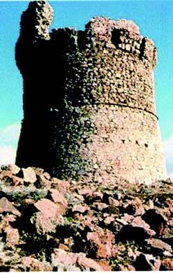
Capo Grosso, 127m high, is located 1.2 miles NE of Capo Bianco and surmounted by a signal station. The prominent villages of Tollare and Barcaggio are situated 1.2 miles and 1.8 miles E, respectively, of the cape. A prominent round tower stands near the village of Tollare.
Pointe d’Agnello is located at the NE end of the peninsula of Cap Corse, 2.8 miles E of Capo Grosso. A round tower stands at the edge of a cliff on this point.
Ile de la Giraglia (43°02'N, 9°24'E) lies N of the peninsula of Cap Corse, 1 mile NNW of Punta d’Angelo. This small island lies at the N end of the coastal bank and is steep and surmounted by an old square tower. A light is shown from a prominent tower, 26m high, standing on the N part of the island.
A rock, awash, lies about 0.2 mile W of the N extremity of the island and a shoal patch, with a depth of 5.3m, lies about 0.2 mile S of the S extremity of the island.
11.3 Mont Cinto (42°22'N, 8°54'E), 2,710m high, is the summit of a mountain range which ends abruptly at its N end in Mont Asto (42°35'N, 9°12'E), 1,533m high.
Vessels approaching the peninsula of Cap Corse from the W or NW will first see this large mountain range which dominates the NW coast of Corse. The outline of the island then becomes lower and rises towards the mountain chain, which runs S to N on the peninsula of Cap Corse.
A tower stands on the coast, 1.5 miles SE of Pointe d’Agnello. Danger de Sainte-Marie, with a least depth of 5m, lies about 0.5 mile N of this tower and Banc de Sainte-Marie, with a least depth of 9.3m, lies about 1 mile ENE of this tower. The sea breaks heavily on these dangers during bad weather. A fringing reef, with a least depth of 2.6m, extends up to about 0.5 mile ENE from the tower.
Rade de Sainte-Marie, formed between the aforementioned dangers and the coast, offers anchorage with moderately good shelter from W winds. A good berth, in depths of 11 to 12m, weed, lies about 0.3 mile NE of the tower and SSE of Danger de Sainte-Marie.
11.4 Iles Finocchiarola (42°59'N, 9°28'E), marked by a lighted buoy, consists of three islets which are surrounded by rocks. A ruined tower stands on the E and largest islet. Sommet Tamarone, 112m high, stands on the coast, 0.7 mile WSW of the ruined tower. Its summit is surmounted by a prominent pyramid.
Pointe de la Coscia, located 1 mile S of Sommet Tamarone, is the S entrance point of Baie de Tamarone. This bay is 0.7 mile wide and affords shelter from W winds.
Macinaggio, a village, is situated in a bay which is entered S of Pointe de la Coscia. It is fronted by a small harbor which is protected by two jetties and has extensive facilities for small craft and yachts.
Marine de Meria, a small cove, is entered 1.5 miles SSE of Macinaggio and can be recognized by an old mill which stands on a rocky promontory on the N side. A small town is situated near the shore at the head of the cove. Sommet Castello, 475m high, stands 1.5 miles WSW of the cove and can be seen over the intervening hills.
Capo Sagro (42°48'N, 9°30'E), marked by a light, is located 11 miles S of Iles Finocchiarola and a signal station stands close N of it. Mont Merizatodio, 778m high, rising steeply 1.5 miles W of the cape and dominates the immediate area.
The village of Erbalunga, situated 1.5 miles SSW of Capo Sagro, stands on the S side of a rocky point; an old tower in ruins stands on the extremity of the point. A prominent convent is situated close N of the village and the isolated belfry of the church at Brando stands 0.8 mile WNW of it.
Tour de Miomo is situated 2 miles S of Erbalunga and stands near a group of houses on a rocky point which overlooks a small beach. Close S of this beach, the coast rises fairly steeply to the summit of Sommet Cornichiola which is 282m high.
Pointe Toga (42°42'N, 9°28'E) is located 2 miles S of Tour de Miomo and has a large steel works situated close SSW of it.
World Port Index No. 39060
11.5 Bastia, the principal commercial port of Corse, comprises three separate harbor areas. Port Saint-Nicholas, in the center, is reserved for commercial operations; Vieux-Port, in the S part, is used by fishing vessels and pleasure craft; and Port de Plaisance de Toga, in the N part, is used by yachts and small craft.
Port of Bastia Home Page http://www.bastiaport.net
Winds – Weather. – The Libeccio, a local W to SW wind, is predominant throughout the year and reaches a maximum frequency in summer. It can be especially violent in this vicinity.
Tides – Currents. – Tides and currents at Bastia are negligible, the water level being affected mainly by periods of strong winds.
Depths – Limitations. – Port Saint-Nicholas is the only harbor accessible to commercial vessels. Pier limitations are, as follows:
| Pier | Length, m | Max. draft, m | Remarks |
|---|---|---|---|
| South Jetty Quay | 157 | 7.5 | General cargo and tankers |
| North Jetty Quay | 125 | 6.5 | General cargo and tankers |
| Aviation | 45 | 6.5 | Vessels less than 40m long |
| Fango 1 | 219 | 6.5 | General cargo and tankers |
| Rive | 90 | 6.7 | General cargo and tankers |
| North Quay | 118 | 6.5 | Cement |
| Northeast Quay | 137 | 6.5 | General cargo and tankers |
| East Quay | 245 | 7.5 | General cargo and tankers |
| No. 8 Quay | 150 | 9.0 | General cargo and tankers |
When ships simultaneously occupy North Quay and Northeast Quay, their lengths are limited to 72m at North Quay and 120m at Northeast Quay.
There are facilities for general cargo, ro-ro, bulk, automobile ferries, tankers, gas, and passenger vessels. Generally, vessels up to 160m in length and 7m draft can be accommodated. It has been reported that vessels up to 200m in length have been handled.
Aspect. – The mountains, which form the backbone of the peninsula of Cap Corse, rise close behind the coastal strip on which Bastia is situated. Le Pigno, the highest peak, stands 2.5 miles inland and is surmounted by a prominent pylon. The spire of the church of Sainte-Marie, situated in the citadel at the S end of the town, is prominent from seaward.
Pilotage. – Pilotage is compulsory for vessels over 45m in length or over 150 grt. Pilots can be contacted on VHF channel 12 or 16 and generally board about 1 mile E of the harbor entrance. Vessels should send an ETA at least 1 hour in advance. Pilots are provided by Haute Corse Station whose center is at Bastia.
Pilots at this station also serve the oil berths at Lucciana and Solenzara.
Regulations. – A Mandatory Access Channel, the limits of which are shown on the chart, lies in the approaches to the port and is entered 7 miles E of the harbor. All vessels over 1,600 grt and carrying hydrocarbons or dangerous substances must report their entry into this channel and maintain a listening watch on VHF. For further information, see paragraph 11.1.
The access route for other vessels lies S of the Mandatory Access Channel and may best be seen on the chart.
The speed limit within 1 mile of the port is 20 knots.
Anchorage. – During W winds, vessels may anchor in Anse de Porto Vecchio. There are depths of 15 to 30m in this bight, about 0.4 mile S of Vieux-Port.
Caution. – Anchoring, fishing, and diving prohibited areas, the limits of which are shown on the chart, lie in the approaches to the port.
Bastia to Golfe de Porto Vecchio
11.6 Etang de Biguglia (42°38'N, 9°27'E) enters the sea 2 miles S of Bastia. This river extends 7 miles SSE and is separated from the sea by a narrow sand dune which is covered with vegetation.
Between Bastia and Alistro, 27 miles SSE, the coast is mostly low and backed by mountains standing from 2 to 5 miles inland.
South Bastia Gas Terminal (42°40'N, 9°28'E) is situated close N of Etang de Biguglia. The berth, which consists of several mooring buoys, lies at the seaward end of a submarine pipeline which extends 0.4 mile ESE from the shore. A lighted buoy is moored about 0.3 mile E of the berth and marks the E approach. Pilotage, which is compulsory, must be obtained from Bastia.
Regulations. – An access channel, 0.5 mile wide, leads W to the terminal berth and is entered about 7 miles E of it. The use of this channel is obligatory for vessels carrying methane.
Vessels using the access channel should not enter it before obtaining permission from the Captain of the Port of Bastia by VHF.
Caution. – A submarine pipeline extends 0.8 mile NE from a point on the shore, 3.2 miles SSE of the South Bastia Gas Terminal. Anchoring is prohibited in the vicinity of this pipeline.
11.7 Punta di Arcu (Pointe d’Arco) (42°34'N, 9°31'E), located 8 miles SSE of Bastia, is surmounted by a ruined tower and a white building. Maison Casone, with a prominent terraced balcony, stands on a ridge, 3 miles NNW of the point. Maison Pinetta, consisting of two low buildings with red roofs, is situated 2 miles SE of Maison Casone.
Furiani, a village, stands 2.5 miles SW of Bastia and is dominated by a white, square bell tower.
Mouillage d’Arco, lying 2 miles N of Pointe d’Arco, affords anchorage, in a depth of 20m, sand and weed, very good holding ground.
Lucciana Oil Terminal (42°33'N, 9°33'E), an offshore pipeline berth, is situated 2 miles S of Pointe d’Arco. It lies in a depth of 9.9m and consists of four mooring buoys. A lighted buoy is moored about 0.3 mile E of the berth and marks the approach. Pilotage is compulsory within a 1 mile radius circle centered on the terminal. Pilots are provided from Bastia and board about 1 mile from the terminal.
Regulations. – A Mandatory Access Channel, the limits of which are shown on the chart, lies in the approaches to the terminal and is entered 6 miles E of the berth. All vessels over 1,600 grt, carrying hydrocarbons or dangerous substances, must report their entry into this channel to the Captain of the Port of Bastia and maintain a listening watch on VHF. For further information, see paragraph 11.1.
11.8 Flueve Golo (42°31'N, 9°33'E) enters the sea 2.5 miles S of Pointe d’Arco. Several oil tanks stand 1.2 miles NW of the river mouth and are visible from seaward.
Between this river and Fium’ Alto, 5 miles S, the low and flat coastal area extends as much as 4 miles inland in places. Two beacons, reported to be not very conspicuous from seaward, stand within this stretch of the coast. To the S of Fium’ Alto, the mountains slope down to the beach.
Marine de Padulella, situated 3.5 miles S of Fium’ Alto, comprises several prominent houses, one of which is very white. The belfry of San-Nicolao, standing 1.5 miles inland, is isolated and conspicuous from seaward.
Port de Campoloro, a yacht marina, lies 2 miles S of Marine de Padulella and is protected by two breakwaters.
Prominent mountains inland include Mont San Petrone, 1,767m high, standing 9 miles W of Marine de Padulella; and Pointe de Caldane, 1,724m high, standing 3.5 miles S of Mont San Petrone.
Tour d’Alistro, a ruined tower, stands 11.5 miles S of Fium’ Alto. Between this tower and Marine de Solenzara, 25 miles SSW, the coast is low, marshy, and provides no sheltered anchorage. A light is shown from a tower, 23m high, standing 0.8 mile NW of Tour d’Alistro. A disused signal station is situated near the light. The chapel of Sainte-Marie stands 6 miles S of Tour d’Alistro and is prominent. Tour Bravone, in ruins, stands on a coastal hill, 48m high, 3.5 miles S of Tour d’Alistro.
Etang de Diane lies 3.5 miles S of Tour Bravone. This lagoon is navigable by boats in winter and has a mouth near its N end. The ruins of Tour de Diane stand on the S side the mouth.
The town of Padulone (Marine d’Aleria), consisting of several houses, is situated close S of the lagoon on the N side of the mouth of the Tavignano. Also in this vicinity, the conspicuous belfry of the village of Aleria and the old penitentiary of Casabianda are prominent from seaward.
The village of Calsarello stands on the S side of the Fium d’Orbo, 5 miles SW of Padulone. It has a building, with a cylindrical tower surrounded by pillars, which is visible from seaward. A tower, which resembles a lighthouse, stands 0.5 mile SSW of the village and is prominent. A stranded wreck lies 1 mile S of the river mouth.
The village of Prunelli-di-Fiumorbo, in which stands a domed belfry, is situated inland, 5.5 miles WNW of Calsarello. The conspicuous belfry at Isolaccio-di-Fiumorbo stands at the head of a valley, 2 miles W of Calsarello.
11.9 Solenzara Oil Terminal (41°55'N, 9°25'E) lies 4.5 miles S of Calsarello. A submarine pipeline extends about 0.3 mile from the shore to a berth, which consists of four mooring buoys, and its seaward end is marked by a yellow and black buoy. A lighted buoy is moored about 0.2 mile E of the berth and marks the approach.
Pilotage is compulsory within a circle of radius 3 miles of the terminal. Pilots are provided from Bastia.
Regulations. – A Mandatory Access Channel, the limits of which are shown on the chart, lies in the approaches to the terminal and is entered about 6.5 miles E of the berth. All vessels over 1,600 grt, carrying hydrocarbons or dangerous substances, must report their entry into this channel to the Captain of the Port of Bastia and maintain a listening watch on VHF. For further information, see paragraph 11.1.
Caution. – Solenzara Air Base is situated 1.5 miles NW of the oil terminal; a prohibited area extends up to 300m from the base.
11.10 The Riviere de Travo (41°54'N, 9°24'E) enters the sea 1 mile SW of the oil terminal. It can be identified by a large bridge, with a chapel situated N of it, standing 1 mile inland. The heights of Ventiseri, on which stand a belfry and a triangulation marker, are located 4 miles WNW of the river mouth.
The prominent village of Solenzara stands on the S side of the mouth of the Solenzara River, 3 miles S of the mouth of the Travo. Sommet de Mozza, 1,124m high, stands 4 miles W of this village and has the appearance of a gigantic column.
Between Solenzara and Punta San Ciprianu, 15 miles S, the coast is rocky and backed a short distance inland by pine-covered mountains. Mont Santo stands 1.7 miles SW of Solenzara. The conspicuous village of Sari is situated on its slopes.
Anse de Cannella, lying 3.5 miles S of the mouth of the Solenzara River, can be identified by the red cliffs which overlook a beach at its head. Anse de Favone, another cove, lies 5 miles S of the Solenzara River and can be identified by a prominent chapel which stands on its N entrance point.
Punta de Fautea (41°43'N, 9°25'E), the E extremity of a rocky promontory, is dominated by Tour de Fautea, which can be seen from some distance seaward. Ile de Fautea, 32m high, lies close off this promontory.
Golfe de Pinarellu (Pinarello Bay) is entered between a point located 1.2 miles S of Punta de Fautea and Ile de Pinarellu, 1.3 miles S. The latter island is 58m high and is surmounted by a conspicuous tower. Ilot Roscana, a group of rocks, lie in the entrance to this gulf. They are red with whitish tops and the largest is 9m high. The gulf affords anchorage to small vessels, in depths of 12 to 15m, in its central part. The holding ground is poor and there is no protection from E winds.
Punta Capicciola, located 1.5 miles SSW of Ile de Pinarellu, is the extremity of a narrow peninsula which is 30m high and reddish in color. A rock lies close off the extremity of the point. Sommet della Vacca Morta, 1,315m high, stands 10 miles W of the point and is black and jagged.
Baie de San Ciprianu (41°38'N, 9°21'E) is entered between Punta d’Arasu and Punta San Ciprianu, 1.2 miles SSW. Ile de Cornuta, reddish and pointed, and Ile San Ciprianu, 24m high with a rounded top, lie 0.2 mile S and 0.2 mile SW, respectively, of Punta d’Arasu.
A light is shown from a structure, 11m high, standing on Punta San Ciprianu.
The bay affords anchorage to small craft, in a depth of 6m. This anchorage is sheltered from W through N to NE, but the holding ground is not good.
11.11 Golfe de Porto Vecchio (41°37'N, 9°20'E) is entered between Punta San Ciprianu and Punta de la Chiappa, 1.2 miles SE. It offers the best anchorage on the E coast of Corse.
Roches de Pecorella, a group of above-water and submerged rocks, lies 0.7 mile ESE of Punta San Ciprianu. This group is marked by a lighted beacon and submerged rocks, shoals, and dangers lie within 0.2 mile of it.
Punta di Benedettu is located on the N shore of the gulf, 1.3 miles W of Punta San Ciprianu. It forms an isolated promontory, 45m high, in the middle of a plain. Anchorage can be obtained SW of Punta San Ciprianu and E of Punta di Benedettu, in depths of 10 to 20m, mud and weed. This roadstead has good holding ground, but is exposed to E winds.
Punta de la Chiappa (41°37'N, 9°20'E) is the S entrance point of the gulf. A light is shown from a prominent structure, 21m high, standing on the point. Roches de Chiappino, a group of above-water rocks and shoals, lies 0.2 mile NE of the point.
Punta di l’Arena is located on the S shore of the gulf, 2.3 miles W of Punta de la Chiappa. The coast between is composed of high cliffs which are interrupted by sandy beaches. Punta di l’Arena is fronted by a sandy spit, which extends NNW, and should be given a wide berth.
Ilot Ziglione, 13m high and wooded, lies about 200m offshore, 0.9 mile SW of Punta di l’Arena. Small vessels may obtain anchorage SW of Punta di l’Arena or, in a depth of 6m, mud and weed, between N and NW of Ilot Ziglione.
Marina d’Arge, located 1.1 miles W of Punta de la Chiappa, is the most prominent beach on the S shore of the gulf.
Paso Nord leads into the gulf between Punta San Ciprianu and Roches de Pecorella, and Passe de l’Est leads between Roches de Pecorella and Roches de Chiappino.
11.12 Porto Vecchio (41°35'N, 9°17'E) (World Port Index No. 39070), a small port, lies at the SW end of the gulf.
Depths – Limitations. – The port consists of a yacht harbor, which fronts the town, and Quai de Commerce, which fronts an area of salt pans, 0.3 mile SE of the town.
There is 250m of total berthing space with a depth of 5.5m alongside. Vessels up to 5.2m draft can be accommodated.
Aspect. – The town, which contains a prominent steeple, is built on a hill and is surrounded by walls. The conspicuous ruins of Chateau de Georgesville, with a gray-green flat roof, are situated 0.5 mile N of the town and surrounded by trees. Several white warehouses stand in the vicinity of the commercial quay.
A directional sector light is shown from a structure standing on the W shore of the gulf and indicates the fairway.
Pilotage. – Pilotage is compulsory for vessels over 60m in length. Vessels should send an ETA 24 hours in advance and then contact the pilot on VHF channel 16 when within range. Pilots are provided from Ajaccio. The pilot boards 1 mile NE of Punta di a Chiappa.
Regulations. – A Mandatory Access Channel, the limits of which are shown on the chart, leads W and SW through the gulf to the harbor. Its seaward entrance lies 0.6 mile NNW of Punta de la Chiappa. All vessels over 1,600 grt, carrying hydrocarbons or dangerous substances, must report their entry into this channel and maintain a listening watch on VHF. For further information, see paragraph 11.1.
Golfe de Porto Vecchio to the Strait of Bonifacio
11.13 Iles Cerbicale (41°33'N, 9°22'E), a group of islands, lies 0.8 mile offshore and is centered 2.6 miles S of Punta de la Chiappa.
From the N to S, the group consists of Ile Forana, 34m high, Ile de Maestro Maria, 5m high, Ile Piana, 36m high, and Ile Pietricaggiosa, 10m high.
Rocher de la Vacca, an islet, lies 0.5 mile ESE of Ile Forana. It is 24m high, isolated, and rather pointed. Danger de la Vacca lies about 0.7 mile SE of Rocher de la Vacca and is marked by a lighted buoy. It consists of two shoal heads with depths of 4 to 4.5m.
Iles du Toro (41°30'N, 9°23'E) lies 2.3 miles SSW of Danger de la Vacca and comprises of a compact group of rocks up to 34m high. The W rock is prominent and has a summit shaped like a finger. Hautfond du Toro, a rock, lies about 0.5 mile E of the group. It has a least depth of 2.7m and is marked by a lighted buoy.
Caution. – The above dangers are surrounded by shoals, rocks, and foul ground, and vessels are advised to give them a wide berth.
Iles Cerbicale is a designated nature reserve. Landing is prohibited between April 1 and August 31 unless special per-mission has been given. The landing of motor vehicles is forbidden at all times.
11.14 Punta di Rondinara (41°28'N, 9°17'E), reddish in color, is the extremity of a peninsula, 59m high, which is connected to the mainland by a low isthmus. Tour de Sponsaglia, a ruined tower, stands 1.2 miles NNE of the point and is conspicuous.
Golfe de Santa Manza (41°26'N, 9°16'E) is entered between Punta di Rondinara and Punta di u Capicciolu, 2.2 miles SSW.
Punta di u Capicciolu is the NE extremity of a peninsula which rises to a remarkable summit, 107m high, 0.2 mile SW of the point. The ruins of Tour Santa-Manza stand 1 mile SW of the point.
Cap Blanc is located at the head of the gulf, 1.5 miles W of Punta di u Capicciolu. It is composed of prominent white cliffs, 46m high.
Anchorage is available in the gulf, sheltered from all but winds between the N and E. The bottom is sand and weed, good holding ground.
Caution. – A dangerous wreck is located 0.7 mile NE of Punta di Rondinara. It is surrounded by an anchoring, fishing, and diving prohibited area of 300m radius.
11.15 Punta de Sporono (Pointe Sperone) (41°22'N, 9°16'E) is located 4.2 mile SW of Punta di u Capicciolu and is the SE extremity of Corse. It is formed by a small tongue of land with vertical sides and is surmounted by a beacon.
Ile Porraggia (41°23'N, 9°16'E), 19m high, lies 2 miles S of Punta di u Capicciolu. This island is surmounted by a pyramid of stones and an islet lies close NE of it.
Iles Gavitti (41°24'N, 9°15'E), lying 0.7 mile NW of Ile Poraggia, consists of a group of rocks up to 4m high, which lie on the middle of a bank with depth of less than 5m.
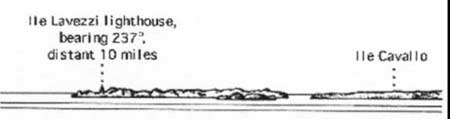
Isles Lavezzi (Archipel Lavezzi) (41°20'N, 9°15'E) lie centered 4 miles S of Punta di u Capicciolu. The group is composed of two principal islands and numerous small islets, reefs, and shoals. A channel, marked by buoys, leads between the group and Corse. It is used only by small vessels, with local knowledge, during clear daylight hours.
Ile Cavallo, the N principal island, lies 1.5 miles E of Punta de Sporono. It is 37m high and is surrounded by rocks and shoals.
Ile Perduto, lying 1.5 miles E of the island, is low and surmounted by a small block of stone. Above and below-water dangers extend up to about 0.4 mile from the islet and are marked by a lighted buoy.
Ecueil de Perduto, a drying rock, lies about 0.5 mile SE of the islet. It is marked by a lighted beacon.
Ile Lavezzi (41°21'N, 9°15'E), the S principal island, consists of a rugged mass of rock. It is surrounded by rocks and is connected to Ile Cavallo by foul ground. Capu di u Beccu, the S extremity of the island, is difficult to identify from the S as it blends with the higher elevations of the island. A light is shown from a structure, 10m high, standing on this cape.
The prominent Pyramide de la Semillante, in commemoration of the wreck of the French frigate La Semillante in 1854, stands on an islet close W of the cape.
Ile Piana lies 0.5 mile NE of Pointe de Sperono and is marked by a prominent beacon.
Ecuel de Lavezzi, with a least depth of 3.1m, lies about 1 mile S of the S extremity of Ile Lavezzi. A light is shown from a structure, 22m high, standing on this shoal and a lighted buoy is moored about 0.4 mile SSE of it.
Caution. – Iles Lavezzi are a designated nature reserve area and diving and fishing are prohibited in the vicinity of the group.
A submarine pipeline extends between the N end of Iles Lavezzi and the S coast of Corse and may best be seen on the chart.
11.16 The Strait of Bonifacio is 6.5 miles wide, but off-lying islands and dangers narrow the principal passage to a width of 3 miles. There are depths of not less than 53m in the fairway between Iles Lavezzi and Isola Razzoli.
Winds – Weather. – In the summer, the predominant winds in the strait are from the W. In the winter, the predominant winds are from the NE. The winds strengthen in the strait and shift from NW to SW, at the E entrance, and from NE to SE, at the W entrance.
Winds from the SW are very rare during the summer in the W part of the strait. They blow most often during the winter before strong gales and storms. However, winds from the NW can quickly develop.
Generally, winds ease up during the night and regain their maximum intensity in the middle of the day.
Tides – Currents. – In the strait, tidal currents are weak and variable, but there are important wind induced currents.
Winds from the NW produce currents which set E at up to 2 knots; winds from the W may produce currents which set E at up to 4 knots; and winds from the E produce currents which set W at up to 3 knots.
Regulations. – Transit is prohibited to ships carrying hazardous cargos flying Italian and French flags. Ships with hazardous cargo flying other flags shall comply with regulations issued by their flag state.
For the purpose of improving the safety of navigation in the Strait of Bonifacio and reducing the risks of pollution of the French and Italian coastlines as a result of groundings or collisions involving tankers, gas carriers, or bulk chemical carriers, a system of reporting, surveillance, and information has been established by the governments of France and Italy in order to warn vessels of any hazard that might threaten their safe passage.
A Ship Movement and Reporting System (MAREP) has been established within the Strait of Bonifacio and its E and W approaches.
The system is mandatory for all vessels of 300 grt and over. The system is referred to as BONIFREP and covers the waters within a 20 -mile radius of Bonifacio (41°23.4'N, 9°09.8'E). The system’s call sign is “Bonifacio Traffic” and is used when reporting to either the Italian authority based at La Maddalena Coast Guard Station, Sardinia or the French authority based at the Pertusato Naval Signal Station, Corsica. Vessels should establish contact on VHF channels 10 and 16.
Vessels are required to transmit their reports upon entering the precautionary areas situated at either end of the routing scheme, or when passing the following demarcations:
1. Eastbound. – A line joining:
- Cabo de Feno Light (41°23.6'N, 9°05.9'E).
- The W end of the N limit of the routing scheme (41°19.2'N, 9°06.5'E).
- The W end of the S limit of the routing scheme (41°16.8'N, 9°06.2'E).
- Capo Testa Light (41°14.7'N, 9°08.7'E).
2. Westbound. – A line joining:
- Punta di Rodinara (41°27.9'N, 9°16.7'E).
- The E end of the N limit of the routing scheme (41°22.6'N, 9°22.4'E).
- The E end of the S limit of the routing scheme (41°21.6'N, 9°23.3'E).
- Punta Galera (41°14.6'N, 9°27.6'E).
The reported information should be formatted, as follows:
| Article | Required Information |
|---|---|
| A | Name, call sign, and IMO number. |
| C | Latitude and longitude. |
| D | Bearing and distance from a landmark. |
| E | Course. |
| F | Speed. |
| O | Draft. |
| P | Cargo category and quantity. |
| Q or R | Vessel defects, damage, or limitations. |
| X | Any additional information, including pollution incidents or cargo loss. |
Vessels of over 5,000 grt transporting oil, dangerous chemicals, or substances likely to pollute the sea or coastline are strongly urged not to pass through the Strait of Bonifacio. This recommendation does not apply to vessels sailing in either direction between Porto Torres and any port on the Italian mainland from Civitavecchia to Napoli.
Caution. – Several submarine cables, some power, lie in the strait and may best be seen on the chart. Anchoring and fishing in their vicinity is prohibited.
 |
|
The Strait of Bonifacio from NE |
|
 |
|
The Strait of Bonifacio |
A magnetic anomaly maybe experienced in the vicinity of the power cables.
11.17 North side of the Strait of Bonifacio. – In clear weather, vessels approaching the Strait of Bonifacio from the E or W can first identify the high mountains in the S part of Corse which may best be seen on the chart.
The N side of the strait between Punta de Sperono (Pointe Sperone) and Capo Pertusato is composed of very rugged, red granite cliffs. Then towards Cap de Feno, the coast consists of relatively low, rocky cliffs. In the vicinity of Bonifacio, the coast comprises of nearly horizontal plateaus which are formed of whitish limestone and backed by angular ridges.
Le Pretre, a shoal, lies about 0.4 mile WSW of Punta de Sperono. It has a least depth of 4.6m and is marked by a beacon.
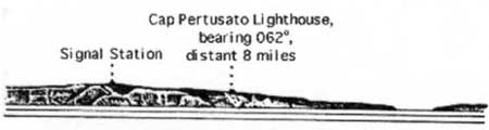
Capo Pertusato (41°22'N, 9°11'E), the S extremity of Corse, is located 1.7 miles W of Punta de Sperono. Ile Saint-Antoine, surmounted by a chapel, lies close S of the seaward extremity of the cape. A light is shown from a prominent structure, 17m high, standing 0.2 mile ENE of the cape. A prominent signal station is situated 0.5 mile NW of the light.
The port of Bonifacio lies 1.7 miles NW of Capo Pertusato and is fully described in paragraph 11.19.
11.18 South side of the Strait of Bonifacio. – The S side of the strait is formed in the W part by the N coast of Sardinia and in the E part by L’Archipelago della Maddalena, an extensive group of islands, which are fully described beginning in paragraph 12.5.
Isola Razzoli (41°18'N, 9°21'E), the NW island of the group, is marked by a light with racon. It is bordered to the NW by Secca di Razzoli, a rock, which is the outermost danger on the S side of the passage. This rock lies about 0.5 mile NW of Isola Razzoli Light and has a least depth of 8m.
Isola la Presa lies 1.5 miles E of Isola Razzoli and a shoal, with a depth of 10m, lies about 0.4 mile N of it.
Directions. – The main passage through the strait lies between Ecueil de Perduto and Ecueil de Lavezzi, on the N side, and Isola Razzoli and Punta Falcone, the N extremity of Sardegna, on the S side. The passage is not less than 3 miles wide and presents no difficulties during daylight.
At night, vessels coming from the N or NE can avoid Ecueil de Perduto by keeping Isola Razzoli Light bearing not less than 180 °. When Ile Lavezzi Light bears 270 °, vessels should then steer SW through the middle of the strait between Isola Razzoli and Ecueil de Lavezzi. After passing through the red sector of Isola Razzoli Light, vessels should alter course and steer W with the latter light kept bearing 080 ° astern until W of Ecueil de Lavezzi. Vessels may then shape courses as convenient for the remainder of the passage.
At night, vessels from the W should steer for Isola Razzoli Light, with a bearing less than 093°, and keep to the S of its red sector. Having passed through the red sector of Ile Lavezzi Light, vessels should then steer NE out of the E entrance of the strait.
Passage de la Piantarella, which leads between the SE coast of Corse and the islands of Ile Poraggia and Ile Ratino, has a least depth of 9m in the fairway. It should be used only during the daytime when the wall beacons on Ile Piana and Punta de Sperono are clearly visible.
Caution. – Deep-draft vessels should take care to avoid the shoal bank which lies 2 miles E of Ile Lavezzi Light.
Passage between Iles Lavezzi and Ecueil de Lavezzi does not shorten the route distance to any great extent and is not recommended for large vessels.
 |
|
The Bay of Gibraltar – Entrance |
11.19 Bonifacio (41°23'N, 9°09'E) (World Port Index No. 39080), a small port, lies on the N side of the strait. The harbor is formed by a cove which affords excellent shelter.
Depths – Limitations. – The harbor is mostly used by ro-ro ferries, fishing vessels, and pleasure craft. The main commercial quay is 60m long with a depth of 7m alongside. Vessels up to 100m in length and 4m draft can be accommodated.
Aspect. – The town is built on the rocky peninsula, which forms the S side of the cove, and is visible from some distance seaward. The cliffs of the peninsula overhang the sea and have chasms which appear as prominent black patches on the white rock. The town is bounded to the E by the white walls of fortifications. The church of Sainte-Marie Majeure, with a prominent belfry surmounted by a small Byzantine dome, stands close W of the fortifications. The conspicuous octagonal tower of Saint-Dominique stands 0.2 mile W of the church. The low and conical belfry of Saint-Francois is situated close to the SW extremity of the peninsula.
Pilotage. – Pilotage is compulsory for vessels over 75m in length. Vessels should send an ETA at least 24 hours in advance. Pilots can be contacted on VHF channel 16 and are provided from Ajaccio. The pilot boards 0.5 mile S of Pointe de la Madonetta.
Caution. – Certain water areas and quays are reserved for use of the French Navy and are not to be used by other vessels without authorization by the Naval Commandant.
The harbor entrance is reported to be difficult to distinguish from a distance.
The Strait of Bonifacio to Golfe de Valinco
11.20 Cap de Feno (41°23'N, 9°06'E), the NW entrance point of the Strait of Bonifacio, is dominated by a ridge which extends 1.5 miles ENE. Three prominent peaks rise from this ridge. The E peak is 219m high and is surmounted by Croix de la Trinite. The W peak is 229m high. A light is shown from a structure, 12m high, standing on the cape.
Iles de la Tonnara, a group of islets, lies close offshore, 2 miles N of the cape. The largest islet of the group is surmounted by a prominent stone pyramid.
Golfo de Ventilegne is entered between Iles de la Tonnara and Punta de Ventilegne, 1.2 miles NW. The N and E shores of this small bay are fronted by a rocky bank.
Baie de Figari is entered between Punta de Ventilegne and Pointe de Figari, 2 miles WNW. Tour de Figari stands on a heap of rocks on the W shore of this bay, 1 mile NE of Pointe de Figari. This tower is reported to be difficult to distinguish against the background. The bay affords good anchorage to vessels with local knowledge, except during SW winds. The bottom is formed of sand and mud with moderately-good holding ground. The best berth is sheltered from NW winds and lies, in a depth of 16m, weeds, about 0.1 mile ESE of Tour de Figari. A directional light leads into the bay.
Tour d’Olmeto (41°29'N, 8°59'E), a conspicuous white tower, stands 2.8 miles NW of Pointe de Figari. Three groups of dangers extend up to 2 miles SW of this tower. Petit Ecueil d’Olmeto, with a depth of 3.9m, is the outermost danger; Grand Ecueil d’Olmeto, with a least depth of 0.2m, lies in the middle; and Ecueil du Pretre, with a depth of 0.8m, lies closest to the shore and is marked by a beacon which was reported destroyed in 1986.
Sommet La Petrosa, 412m high, stands 2 miles N of the tower and overlooks this section of the coast.
11.21 Les Moines (41°27'N, 8°54'E), consisting of three groups of dangerous rocks, lies 1.8 miles W of Petit Ecueil d’Olmeto. The middle group of rocks is the highest and rises up to 6m. A light is shown from a structure, 31m high, standing on the S group of rocks.
Rocks and shoals extend up to 0.2 mile SW of the light and an isolated sandy patch, with a least depth of 17m, lies about 1.2 miles W of the light.
The passage between Les Moines and Petit Ecueil d’Olmeto is 1.3 miles wide. The N extremity of Les Moines is steep-to and the two N rocks are clearly visible.
Capu di Zivia (Pointe Latoniccia) (41°31'N, 8°50'E) is the extremity of a promontory which rises to Sommet de Pietra Nera. This peak, which stands 1.7 miles NE of the cape, is 197m high and rocky.
Ilot Latonniccia lies 0.2 mile S of the cape. It is steep, 20m high, and whitish in color. A rocky patch, with a depth of 4.7m, lies about 0.2 mile S of this islet and foul ground extends between them.
Haut-Fond de Latoniccia, a rocky area with a least depth of 23m, lies about 2.5 miles S of Capu di Zivia. During W winds, vessels should avoid this locality because of the heavy sea caused by eddies.
Between Capu di Zivia and Capo Senetosa, 3.5 miles NW, the coast is rocky, indented by several coves, and backed by low mountains which form prominent isolated blocks.
Capo Senetosa (Pointe Senetose) (41°34'N, 8°47'E), a prominent headland, is the SW extremity of Corse. It rises to a summit, 129m high, 0.8 mile inland which is surmounted by a gray tower. A light is shown from a prominent structure standing 0.5 mile SE of the point. This light structure is 13m high and consists of two white towers joined by a white building.
Pointe Aquila, a low and narrow tongue of land, projects 250m SSW from the cape. The cape is fronted by above and below-water rocks and should be given a wide berth. Scoglio Blanco, the outermost visible rock, lies about 0.2 mile NW of the cape.
The coast between Capo Senetosa and Punta di Camo Moro, 5 miles N, is rocky, sheer, and jagged. Pointe d’Eccica, located 2 miles NNW of Capo Senetosa, is bordered by a peak, 111m high, which rises close E of it. Ile d’Eccica, low and bare, lies 0.5 mile W of the point. The channel between this islet and the point is encumbered with rocks.
11.22 Golfo de Valinco (41°40'N, 8°49'E), entered between Pointe di Camo Moro and Capo di Muro, 9 miles NW, offers good shelter during E and S winds, but is exposed to winds between the W and N. Pointe di Camo Moro is surmounted by a fort with a large prominent tower.
The gulf extends 6 miles ENE and is enclosed by mountains. Pointe di Furchiccioli, 1,535m high, stands 5 miles NE of the head of the gulf. This peak appears as a plateau with a bare ridge and is very steep on its W side. Pointe di Buturetu, 870m high, is crowned by a rock which has the appearance of a citadel. This peak stands 2 miles N of the head of the gulf and overlooks the village of Olmeto, which is situated on its E slopes. Pointe Savaziglia, 669m high, stands 2 miles E of the head of the gulf. This mountain has two peaks and overlooks the village of Viggianello which is situated on its W side.
The S coast of the gulf recedes to form a bight close E of Pointe di Camo Moro. The village of Campo Moro is situated at the head of this bight. A large modern chateau, with three prominent turrets, stands close SW of the village. Anchorage is available, in depths of 12 to 24m, weed, good holding ground, N of the chateau and about 0.2 mile from the beach at the head of the bight. Shelter is afforded from winds between the SW and W, but this roadstead is untenable with winds from the NW.
Pointe di Falumbaja (Pointe Cardicciani) is located 2 miles E of Pointe di Camo Moro. It is fronted by a group of detached rocks, one of which is white and prominent.
11.23 Propriano (41°41'N, 8°54'E) (World Port Index No. 39090), a small port, lies at the inner end of the gulf.
Depths – Limitations. – The main harbor, which is mostly used by pleasure craft and ferries, is formed by a jetty which extends 0.2 mile N from the shore. A basin for fishing vessels lies in the inner part of the harbor and an extensive yacht marina lies close E of it.
The commercial basin has a quay, 100m long, with a depth of 5.5m alongside and a dolphin berth which can accommodate ro-ro vessels up to 135m in length and 7m draft.
Aspect. – The town can be identified by a conspicuous church, with a square belfry, which stands isolated on high ground. A light is shown from a structure, 17m high, standing on the seaward extremity of the harbor jetty.
Pilotage. – Pilotage is compulsory for vessels over 60m in length. Pilots are provided from Ajaccio. Pilotage is available and advisable for all vessels without local knowledge. The pilot may be contacted on VHF channel 9 or 16. The pilot boards 2 miles W of the port entrance.
Anchorage. – Anchorage is available, in depths of 10 to 12m, sand and weed, close E of the N jetty head, but this berth is exposed to winds between the W and N.
Caution. – During NW winds, a swell enters the harbor.
Obstructions and rocks lie on the N side of the main harbor jetty and it should be given a wide berth.
11.24 Pointe d’Aglio (41°41'N, 8°53'E), marked by a tower, is located 0.8 mile NW of Propriano.
The head of the gulf comprises a wide, sandy beach. The Riviere Barachi flows into the gulf near the N end of this beach.
Pointe di Bitussu (Pointe de Taravo) located 2.3 miles WNW of Pointe d’Aglio, is low and fringed by rocks. A prominent tower stands 0.5 mile N of the point and a sandy beach extends 1.5 miles NW from it to Porto Pollo.
Porto Pollo, a small bight, offers shelter during NW winds although the holding ground is not good. Vessels should anchor, in a depth of 20m, about 300m offshore in its SW part.
Pointe di Porto Pollo is located SW of Porto Pollo and is fronted to the S and SE by foul ground.
Baie de Cupabia is entered between Pointe di Porto Pollo and Cap Nero, 3.5 miles WNW. Both of its entrance points are fringed with rocks and shoals. The E shore of the bay is rocky and overlooked by Tour Capanelle, which stands 1.5 miles N of the S entrance point. Anchorage can be taken, in depths of 12 to 15m, sand and weed, about 0.2 mile offshore, WNW of Tour Capanelle. This berth is sheltered from all winds except those from the SW.
Cap Nero, the N entrance point of the bay, is formed of high, black cliffs. Tour Nero stands on the cape. It is light-colored and shows up clearly amongst the vegetation. Sommet della Monteta, 349m high, stands 1.5 miles NE of the cape and is prominent from seaward.
A detached rock, with a depth of 2.4m, lies about 0.7 mile E of Cap Nero.
11.25 Capo di Muro (41°44'N, 8°40'E), the N entrance point of the gulf, is located 2.3 miles NNW of Cap Nero. A light is shown from a tower, 7m high, standing on the cape.
This cape is fronted by a bank, with depths of less than 18m, which extends up to 0.5 mile S and SW of it. A detached rocky patch, with a least depth of 11m, lies about 1 mile S of the cape.
11.26 Golfe d’Ajaccio (41°50'N, 8°43'E) is entered between Capo di Muro and Pointe de la Parata, 9.5 miles NNW and extends 10 miles NE.
A prominent television tower surmounts a peak, 580m high, which stands 5 miles ENE of Capo di Muro.
Pointe Guardiola, located 0.5 mile N of Capo di Muro, is fringed by rocks which extend up to 0.5 mile offshore. Sommet Guardiola, 167m high, stands 0.5 mile E of the point and Tour Muru stands on a cliff, close E of its summit.
The gulf is overlooked on its E side by Cozzanaccio, 1,060m high, which rises 12.5 miles NE of Capo di Muro. The coast extending to the NE of Capo di Muro forms three open bays which are separated by protruding points.
Pointe de la Castagna, which separates the first and second bays, is located 3.7 miles NE of Pointe Guardiola. It is rounded and rises to a summit, 91m high, which is surmounted by a tower.
Pointe de Sette Nave, which separates the second and third bays, is located 3.2 miles NE of Pointe de la Castagna and fronted by foul ground and rocks. It is the W extremity of a peninsula which is surmounted by Tour Isolella, a prominent tower. La Campanina, a shallow rock, lies about 0.5 mile SW of the point and is marked by a beacon, 7m high.
Pointe de Porticcio, which borders the N side of the third bay, is located 2.6 miles NE of Pointe de Sette Nave and is fronted by rocks. A prominent hotel is situated 0.2 mile E of the point. Ecueil Dorbera, a group of rocks, lies about 0.3 mile SSW of the point.
To the N of Pointe de Porticcio, the head of the gulf is bordered by a sandy beach. An airport is situated on a plain, which adjoins the beach, 2.5 miles NNE of the point.
11.27 Pointe d’Aspretto (41°55'N, 8°46'E), located 2.4 miles NNW of Pointe de Porticcio, is the E entrance point of Baie d’Ajaccio. Darse d’Ajaccio, a small enclosed harbor, lies on its E side. The hangars and buildings of a French naval air station stand on the point and are conspicuous.
Les Scoglietti, a group of above-water and submerged rocks, extends up to about 0.4 mile S of Pointe d’Aspretto. An obstruction, with a depth of 11.4m, lies close S of this group.
The W entrance point of Baie d’Ajaccio is located 1 mile WSW of Pointe d’Aspretto. A conspicuous citadel stands on this point. A light is shown from a tower, 13m high, standing at the E side of the citadel.
La Citadelle, a shoal patch, lies about 0.2 mile S of the citadel. It has a least depth of 3.3m and is marked by a lighted beacon. A rocky shoal, with a depth of 3.5m, lies about 0.1 mile W of the beacon.
World Port Index No. 39100
11.28 Ajaccio, the capital of Corse, is a commercial port and the site of a naval base. The port occupies Baie d’Ajaccio and consists of three basins, which lie on the W side of the bay, and an outer harbor which consists of the center and E side of the bay.
Port of Ajaccio Home Page http://www.corse-du-sud.cci.fr
Winds – Weather. – The prevailing winds are from the NE and very mild weather exists all year round. During the winter, strong SW winds may be experienced.
Tides – Currents. – Tides and currents are negligible. Winds from the SW may sometimes cause a sea and swell in the harbor.
Depths – Limitations. – The approaches to the bay impose no limitations on the size of vessels using it. The fairway leading through the harbor to the various basins is deep and clear.
Bassin de la Ville, the S harbor basin, is protected from the S by the Jetee de la Citadelle. Its S part is used by fishing vessels and pleasure craft.
Quai de la Gare Maritime, 200m long, and Quai l’Herminier, 90m long, form the W side of this basin and have depths of 6.5 to 7m alongside. Jetee des Capucins projects E from the N end of Quai l’Herminier. Its S side has a berth, 100m long, with a depth of 7m alongside.
Bassin des Capucins lies N of Bassin de la Ville. The N side of Jetee des Capucins forms the S side of this basin and has a berth, 135m long, with a depth of 7m alongside. Jetee du Margonajo and Quai de la Chambre de Commerce form the N and W sides of the basin and have depths of 7.5m alongside.
The above quays have extensive ro-ro facilities and can accommodate vessels up to 200m in length and 7m draft.
Bassin de Cannes, the N harbor basin, is occupied by an extensive yacht marina.
Appontement Jeanne d’Arc, with a depth of 6m alongside, extends from the NW corner of the bay and is used by LNG vessels.
Appontement Saint Joseph, with a depth of 7.5m alongside, extends from NE corner of the bay and is used by oil tankers.
Tahiti LNG terminal, consisting of a mooring buoy, lies 0.2 mile NE of Pointe d’Aspretto. A submarine pipeline extends NNE from the berth to the shore. Vessels up to 1,500 tons and 5m draft can be handled.
Aspect. – The olive-covered slopes of Mont Salario rise behind the town and several prominent chapels are situated on them.
A French naval seaplane base, with hangars and workshops, is situated on the S side of Pointe d’Aspretto. Two radio masts stand 0.5 mile N of this base and two radio masts stand on a cliff on the E shore of the bay, 0.3 mile NW of the base.
Pilotage. – Pilotage is compulsory for vessels over 60m long. Pilots can be contacted on VHF channels 12 and 16 and generally board about 0.5 mile ESE of La Citadelle Beacon. Vessels should send an ETA at least 24 hours in advance and a confirmation 1 hour before arrival.
This station also provides pilots for Propriano, Bonifacio, and Porto-Vecchio.
Regulations. – A Mandatory Access Channel, the limits of which are shown on the chart, lies in the approaches to Ajaccio and is entered 15 miles SW of the port. All vessels over 1,600 grt, carrying hydrocarbons or dangerous substances, must report their entry into this channel and maintain a listening watch on VHF. The use of this channel is reported to be only authorized during daylight. For further information, see paragraph 11.1.
Restricted military zone areas, the limits of which are shown on the chart, lie in the vicinity of the base at Pointe d’Aspretto and in the vicinity of Appontement Saint Joseph, at the NE corner of the bay. Vessels without prior permission from the military authorities are prohibited from entering these areas.
A restricted area, the limits of which are shown on the chart, lies in the vicinity of Appontement Jeanne d’Arc, at the NW corner of the bay. Vessels and small craft are prohibited from entering or anchoring in this area when a methane tanker is berthed at the pier.
A navigation restricted area, the limits of which are shown on the chart, lies N of a line between Les Scoglietti and the citadel. Within this area, sailing vessels and small craft must proceed only for the purpose of entering or leaving a harbor basin or an anchorage berth. Such craft must stay clear of any vessels 50m in length and over. Bathing, diving, or using beach craft or wind surfers is prohibited within this area.
Anchorage. – There is good anchorage, but SW and ENE winds, if strong, usually cause a moderately rough sea.
Mouillage de la Ville, in Bassin de la Ville, offers anchorage to small vessels, in depths of 5 to 7m, with a swinging radius of 115m.
Large vessels, of unlimited size, anchor in Mouillage des Capucins, which lies E of Bassin des Capucins, in depths of 20 to 25m, mud, excellent holding ground.
Caution. – Submarine cables extend S from the vicinity of the W entrance point of the bay. They extend out of the gulf and along the SW coast of Corse and may best be seen on the chart.
A prohibited anchorage area, the limits of which are shown on the chart, lies in the vicinity of the entrance to Bassin de la Ville.
Seaplanes from the naval air station frequently carry out practice flights.
Several unlighted mooring buoys are reported to be situated within the bay.
Anchoring and fishing are prohibited in the vicinity of the Tahiti LNG Terminal.
11.29 Chapelle des Grecs (41°54'N, 8°43'E) stands on the coast, 1 mile WSW of Ajaccio. La Guardiola, a drying rock surrounded by foul ground, lies about 0.4 mile S of the chapel. A light is shown from a prominent tower, 8m high, standing on the rock.
La Botte, a rock, lies about 0.6 mile WSW of La Guardiola. It is 4m high. An outfall pipeline extends 0.3 mile S from the shore, close W of this rock.
Pointe Scudo, located 2 miles W of Chapelle des Grecs, is fronted by rocks and shoals. A prominent house, with a tower, stands 0.5 mile N of this point.
Pointe de la Parata is located 3 miles WSW of Pointe Scudo. Its summit, 58m high, stands close N of the seaward extremity and is surmounted by Tour Parata. Sommet Scuda, 529m high, stands 3.5 miles ENE of the point and is surmounted by a pyramid.
The gulf is overlooked on its N side by Pointe di Lisa, 790m high, and Punta Pozzo di Borgo, 780m high, which stand 4.5 and 5.5 miles NE, respectively, of Pointe de la Parata. A prominent chateau is situated near the summit of Punta Pozzo di Borgo and a dome-shaped monument stands on its S slope.
Iles Sanguinaires (41°53'N, 8°36'E), a chain, extends up to about 2 miles SW of Pointe de la Parata. It consists of several shoals, three rocky islets, and the main island of Grand Sanguinaire.
Grand Sanguinaire lies at the SW end of the chain. A light is shown from a prominent structure, 16m high, standing on the summit of the island and a tower stands near the S end.
Rocks and shoals extend up to 0.5 mile SW of the SW end of the island and up to 0.3 mile SE of its SE end. Ecueil du Tabernacle, a rock with a least depth of 3m, lies 0.6 mile SE of the SE end of Grande Sanguinaire and is marked by a lighted buoy.
Passe des Sanguinaires leads between Ile Porri, the N islet of the chain, and Pointe de la Parata. It is 0.2 mile wide and has a depth of 7m. Vessels of moderate draft, with local knowledge, can use this channel during daylight and with good weather.
Caution. – Vessels entering Golfe de Ajaccio should steer to pass clear of Iles Sanguinaires and at least 1 mile SW of the S extremity of Grande Sanguinaire.
Golfe d’Ajaccio to Golfe de Calvi
11.30 Cap de Feno (41°58'N, 8°36'E) is located 4.3 miles N of Pointe de la Parata. The coast between is moderately high and rocky. The cape consists of steep cliffs and Tour de Feno, a prominent tower, stands close E of its seaward extremity.
La Botte, a rock 22m high, lies about 0.7 mile offshore, 1.2 miles S of the cape. Ecueil de Fico, with a least depth of 2m, lies about 0.5 mile N of La Botte.
Golfe de Lava is entered between Capo di Feno and Pointe Parragiola, 3.5 miles NE. Pietra de Piombata, 10m high, lies 1.2 miles ENE of Capo di Feno. This rocky islet is surrounded by dangerous rocks. La Figiera, another small islet, lies 0.2 mile offshore, 1 mile ESE of Pietra de Piombata. During good weather, anchorage can be obtained in the N part of this gulf.
Bank de Provencale, with a least depth of 15.4m, lies about 1.7 miles NE of Pointe Parragiola.
Golfe de Sagone is entered between Pointe Parragiola and Pointe di u Puntiglione, 6 miles NNW. Pointe Palmentoju is located on the SE side of the gulf, 4.1 miles NE of Pointe Parragiola. It is surmounted by a ruined tower and fronted by rocks. Recife de Paliage, a rocky shoal area, lies 1.4 miles W of this point and has a least depth of 0.9m.
Pointe Saint-Joseph is located on the NE side of the gulf, 2.8 miles N of Pointe Palmentoju. Recife de San Giuseppe (Recife de Saint-Joseph), a group of rocks and shoals, extends up to 1 mile SW of this point. A sandy beach extends 1.5 miles SSE from Pointe Saint-Joseph to Pointe Capigliolu, which is fronted by rocks and surmounted by two ruined towers.
Anse de Sagone, in the NE part of the gulf, is entered E of Pointe de la Batterie (Pointe Albellu), which is located 1.5 miles NW of Pointe Saint-Joseph. Sommet Saltelle, 924m high, stands 3 miles ENE of the head of this bay and overlooks the area. Anchorage is available, in a depth of 12m, sand and mud, in the NW part of the bay. Local knowledge is advised.
Pointe de Triu, located 1 mile W of Pointe de la Batterie, is fronted by a rocky area with a least depth of 2.7m. Plateau de la Licciola, with a least depth of 9.2m, extends up to about 0.5 mile SSW of the point.
11.31 Punta di u Puntiglione (Pointe de Cargese) (42°08'N, 8°35'E), the N entrance point of the gulf, is fronted by rocks. A prominent tower surmounts the summit of a hill, 162m high, which stands 0.5 mile NE of the point. The village of Cargese, situated 0.7 mile ENE of the point, is laid out like an amphitheater and has two prominent belfries.
Recif Marifaja, 1.5m high, lies about 0.6 mile offshore, 2 miles ESE of the point. A shoal patch, with a depth of 7.1m, lies 0.6 mile WSW of the point.
Golfe de Peru (42°08'N, 8°35'E) lies between Punta di u Puntiglione and Punta d’Omignia, 1.5 miles NW. The latter point is fronted by an above-water rock and is formed by a long and narrow peninsula which is surmounted by a tower.
 |
|
The Bay of Gibraltar – Entrance |
Punta d’Omignia Golfo de Chioni is entered between Punta d’Omignia and Pointe d’Orchino, 1.7 miles N. The latter point is fronted by rocks and is marked by a tower which stands 0.7 mile ENE of it.
A shoal patch, with a depth of 9m, was reported (1986) to lie about 1 mile NNE of Pointe d’Orchino.
A bight is formed between Pointe d’Orchino and Punta alli Tuselli (Pointe Tuselli), 1.8 miles N. Port d’Arone (Anse d’Arone) and Cala di Palu, two coves, lie in the inner N part of this bight. Except at the head of this bight, where there is a sandy beach, the shores consist of blackish cliffs. Small vessels can obtain shelter from NW winds within the two coves. Local knowledge is required.
11.32 Cap Rosso (Cap Rossu) (42°14'N, 8°32'E) is composed of cliffs and is fronted by several rocks. Tour de Turghio stands on the summit of a gigantic red granite cliff, 342m high, 0.5 mile E of the extremity of the cape.
Golfe de Porto is entered between Cap Rosso and Cap Senino, 5 miles NE. The coasts of this gulf are steep and surmounted by high mountains. The S shore is bordered by some rocky islets which lie close inshore. Pointe Palani, located 1 mile E of Cap Rosso, has a conspicuous granite pinnacle standing above it.
The village of Porto is situated at the head of the gulf and is separated from the sea by a rocky promontory on which stands a prominent tower. A quay, used by small craft, lies on the N side of this promontory.
Golfe de Girolata is entered between Cap Senino and Punta Rossa, 2 miles NW. Cap Senino is the W extremity of a promontory which is dominated by Mont Senino, 619m high and very steep. Girolata is situated in a cove at the head of the gulf, A fort, surmounted by a tower, stands on the NW entrance point of the cove. Anchorage can be obtained, in depths of 20 to 29m, within this cove.
Sommet Porcire, 540m high, stands 1.8 miles NE of Punta Rossa and overlooks this part of the coast.
Pointe Palazzo is located 2.7 miles N of Punta Rossa. The coast between consists of high, rugged, and dark red cliffs. Pointe Palazzo is topped by a plateau, the striated rocks of which resemble a row of books. Ilot Palazzo, 58m high, lies close NW of the point.
11.33 Ile de Gargalo (Ile de Gargalu) (42°22'N, 8°33'E) lies 0.5 mile SSW of Pointe Palazzo and is separated from the mainland by a very narrow passage. The summit of the island, 127m high, is surmounted by a tower and Le Casque, a distinctive helmet-shaped rock, stands on a small plateau, close NW of it. A light is shown from a structure, 6m high, standing on the NW end of the island. Ilot Garganello, a small islet, lies close off the S extremity of the island.
Baie d’Elbo indents the coast between Pointe Palazzo and Pointe Nera, 1 mile E. Marine d’Elbo, a sandy beach, is located at the head of a small inlet, in the S shore of the bay. There are several buildings here and it is an important center for lobster fishing. Ilot Pori, 31m high, lies 0.5 mile ENE of Pointe Nera. The shores of Baie de Focolara, which is entered close E of the islet, consist of high cliffs.
Sommet Mufrareccia, 407m high, stands 0.8 mile inland, 3.7 miles NE of Pointe Palazzo.
Les Scoglietti, a group of above-water rocks up to 4.3m high, lie off a point located 0.8 mile NW of this hill. The group is surrounded by foul ground and rocks, awash.
Golfe de Galeria, is entered between Pointe Ciuttone, located 6 miles NE of Pointe Palazzo, and Pointe Stollo, 1.7 miles SW. The village of Galeria is situated at the S corner of the gulf and Tour Galeria stands on low ground, 0.5 mile SW of it. A rocky area, with a least depth of 1.8m, fronts the shore at the head of the gulf and extends up to about 0.3 mile offshore, N of the village. Pointe Ciuttone is formed by an isolated outcrop of red granite. This outcrop rises to a height of 200m about 0.5 mile inland and a stone pyramid stands about halfway up its slope. The gulf is easily identified by Capu Tondu, 840m high, which stands 2 miles S of its head and has an isolated peak. The gulf offers fairly good anchorage during good weather, but with a W swell, it becomes untenable. Fog appearing SW of Capu Tondu usually precedes the arrival of the swell. Anchorage can be taken, in depths of 13 to 17m, sand, mud, and weed, about 0.3 mile WNW of Tour Galeria.
11.34 Baie de Crovani (42°28'N, 8°29'E) is entered between Capo Morsetta, located 2 miles N of Pointe Ciuttone and Cap Martino, 1.3 miles SSE. A low islet, which is fronted by rocks on its SW and S sides, lies close SW of Capo Morsetta. A sandy beach lies at the head of the bay and the prominent buildings of the village of L’Argentelle are situated near its S end. The bay offers good anchorage, sheltered from all but W winds.
Sommet Vigatoggio, 259m high, stands 0.7 mile NE of Capo Morsetta. This peak is surmounted by a pyramid; another one is situated on its SW slope.
Tour Turccia, in ruins, stands on a bare and pointed peak, 294m high, 1.5 miles NNE of Capo Morsetta.
Capo al Cavallo is located 2.6 miles NNE of Capo Morsetta. A prominent disused signal station is situated on a summit, 322m high, standing 0.4 mile ESE of the cape.
Banc de Cavallo, with a least depth of 31m, extends up to 1.8 miles NW of Capo al Cavallo. During bad weather, the sea breaks heavily on this bank and vessels are advised to stay at least 3 miles from it.
Baie Nichiareto, entered 2 miles ENE of Capo al Cavallo, is reported to give good shelter from W to SW winds. A rock, 17m high, lies 0.3 mile SE of Pointe Bianca, the S entrance point of the bay.
Pointe de Revellata (42°35'N, 8°43'E), located 4.7 miles NE of Capo al Cavallo, is the N extremity of a peninsula which rises on its E side to a ridge. Sommet Belloni, surmounted by a prominent black pyramid, is the highest peak of this ridge and stands 0.7 mile SW of the point. The W coast of the peninsula consists of nearly perpendicular cliffs. A pointed rock, 27m high, fronts the NE side of Pointe de Revellata. A light is shown from a tower with a dwelling, 16m high, standing on the point.
Caution. – Fishing is prohibited in an area which extends NW from Pointe de Revellata.
Golfe de Calvi
11.35 Golfe de Calvi (42°34'N, 8°47'E) is entered between Pointe Saint Francois (Punta San Francesco), located 0.7 mile E of Pointe de Revellata, and Pointe Caldano, 2 miles ENE, which is surmounted by a tower.
Vessels approaching the gulf may identify it by Mont Grosso, 1,941m high, standing 8.5 miles SE of Pointe Saint Francois, and by the E termination of a chain of mountains which dominates this region.
Other conspicuous landmarks include the chapel of Madonna della Serra standing at a height of 216m, 1.5 miles SW of Pointe Saint Francois; Maison Renucoli, flanked by two clusters of trees, situated 1.5 miles SSE of Pointe Saint Francois; the red railroad station of Calenzana-Lumio standing at the head of the gulf, 1.5 miles S of Pointe Caldano; and the flat summit of Bestia, 803m high, standing 4 miles SE of Pointe Caldano. About halfway up the W slopes of Bestia, a road can be seen leading to the prominent village of Montemaggiore, which stands 1.5 miles S of the summit. The slender steeple of a church is situated in the village and is conspicuous from seaward.
11.36 Calvi (42°34'N, 8°46'E) (World Port Index No. 39110), a small port, lies close SE of Pointe Saint Francois.
Depths – Limitations. – The harbor area lies S of the citadel and E of the lower town. It is protected from the NE by the land formation. A small jetty projects SSE from the coast off the SE extremity of the citadel and provides partial protection during N and NE winds. There is an extensive yacht basin which is protected by a breakwater.
Quai Nord, the principal quay, is 140m long and has facilities for ro-ro vessels. Vessels up to 120m in length and 5.5m draft can be accommodated.
A mooring buoy is situated S of the quay.
Aspect. – The town is divided into two parts. The N, or high part, is surrounded by the walls of a prominent citadel and has a bell tower situated in its midst. The S, or lower part, is situated immediately SW of the citadel and is overlooked by two forts, one of which is surmounted by a white building. A tall and slender steeple stands in this part.
Pilotage. – Pilotage is compulsory for vessels of 60m length or more and for vessels over 150 gross tons. The pilot is provided by Bastia.
Anchorage. – Anchorage in the gulf is excellent with W or SW winds, but winds from the N and NE can cause rough seas. The recommended berth, in a depth of 12m, sand and weed, lies about 0.2 mile E of the head of the breakwater of the yacht basin.
Caution. – Several submarine cables are landed in the vicinity of Pointe Saint Francois. Anchoring and fishing are prohibited within 0.6 mile NNE of the point.
11.37 Pointe d’Espano (42°36'N, 8°48'E) is located 1 mile N of Pointe Caldano. The coast between is low and fringed by rocks. The ruins of a tower stand on the N side of Pointe d’Espano, which is fronted by Ile de Spano (Ile d’Espano), 15m high and flat, on its W side.
Pointe Saint-Ambrogio is located 1.2 miles E of Pointe d’E spano. Rocher Elephant, two round and prominent rocks, are situated close inland, between these two points. The rocks stand on the slope of a hill and are so named because of their shape. A small yacht harbor, protected by two moles, lies close S of Pointe Saint-Ambrogio.
Pointe Saint-Damiano is located 1.3 miles ENE of Pointe Saint-Ambrogio. This point is low, but can be readily identified by its white rocks. The village of Algajola, with its slender steeple, stands 0.5 mile ESE of the point and a wide and sandy beach extends 0.7 mile NE from it. Ecueil de l’Algajola (Danger de l’Algajola), a group of shallow rocks, lies 1.5 miles NW of Algajola. This group is marked by a beacon which is difficult to distinguish. The beacon was reported (1992) to be destroyed.
Punta di Vallitone is located 1.5 miles NE of the village. This point is low, rocky, and a tower stands near its extremity. La Galere, a rock awash, lies 0.3 mile NE of the tower and should be given a berth of at least 0.5 mile.
11.38 Iles Rousses (42°39'N, 8°56'E), a group of four yellowish islands, lies close off the coast, in the vicinity of the town of L’Ile Rousse. Grande Ile Rousse (Isula la Pietra), the largest island, is connected by a causeway to Ile Sicota, the S island of the group, which in turn is connected by another causeway to the mainland. The other two islands lie close N of the W end of Grande Ile Rousse.
Vessels approaching this part of the coast can easily identify Sommet d’Orcica, 409m high, which is conical and stands 1.2 miles SSE of Ile-Rousse. The village of Monticello is situated on its E slope and the domed chapel of Saint-Francois is situated 0.5 mile SE of the village.
11.39 L’Ile Rousse (42°38'N, 8°56'E) (World Port Index No. 39120), a small and partially-protected harbor, is formed by a jetty extending SE from the causeway which links Grande Ile Rousse to Ile Sicota.
Depths – Limitations. – A quay on the S side of the jetty is 128m long and has a depth of 4.6m alongside. Another quay, 125m long, has a depth of 7.2m alongside. The harbor has facilities for ro-ro vessels and is mostly used by ferries. Vessels up to 160m in length and 7.1m draft can be accom-modated.
Aspect. – Prominent features in the town include the twin steeples of the church of Sainte-Marie, which is situated 0.5 mile SSE of the W extremity of Ile Sicota; the cathedral standing close E of the church ; and a large red hotel situated close SE of the cathedral.
A prominent disused signal station stands on the N slope of a hill, 0.7 mile W of the town.
Pilotage. – Pilotage is compulsory for vessels 60m or more in length and vessels of more than 150 gross tons. The pilots are available from Bastia. The port monitors VHF channel 16.
Anchorage. – Anchorage is available for vessels of any size, in depths of 14 to 27m, NE of the town, but the roadstead is exposed to winds from between the NW and NE. Small vessels can anchor closer inshore, S of the jetty head.
Caution. – Danger de L’Ile Rousse, a rocky area with a least depth of 6.5m, lies within 0.5 mile NNW of the extremity of the jetty.
Haut-Ford de Naso, with a least depth of 13m, lies about 0.5 mile NE of the jetty head. Heavy seas break over this shoal during bad weather.
11.40 Pointe de Lozari (42°39'N, 9°00'E), located 3 miles E of L’Ile Rousse, is bordered on its W side by a large house and several hangars, with red roofs, and on its E side by a long sandy beach on which are situated several houses. The village of Belgodere stands 3.2 miles S of the point and is conspicuous because of its elevated position on the slopes of a blackish and bare peak, 1,207m high.
From seaward, the rocky coast between L’Ile-Rousse and Golfe de Saint Florent, 15 miles ENE, is dominated by a mountain range which stands 2.5 miles inland and has peaks of 396 to 488m high. The most conspicuous summits are Mont Iffana, 475m high and rounded, standing 8.5 miles ENE of L’Ile-Rousse; Mont Robbia, 413m high with a very sharp peak, standing 2.5 miles ENE of Mont Iffana; and Mont Genova, 418m high and cone-shaped, standing 1.8 miles SE of Mont Robbia.
Anse de Peraiola is entered 2.7 miles NE of Point de Lozari. The ruins of a tower stand on its N entrance point and a cliff nearby forms a prominent white patch which can be seen from seaward. Punta di l’Acciolu (Pointe de l’Alciolo) is located 1.8 miles N of this inlet. This point rises steeply to Mont Orlando, 170m high, which stands 0.5 mile SE of it. A prominent rock, which is beak-shaped and pointing W, stands on the point.
Punta di Mignola is located 11.7 miles NE of L’Ile Rousse. This point can easily be recognized by a black pyramid standing at a height of 152m, 0.5 mile S of it. Irregular depths lie up to 2 miles N of the point and cause a very heavy sea during W winds.
Punta di Curza is located 2.5 miles E of Punta di Mignola. This point is whitish, low, and salient and a long sandy beach extends to the W of it. Mont Porcini, 114m high, stands 0.7 mile S of the point.
Punta Mortella (42°43'N, 9°16'E) is located 2 miles SE of Punta di Curza. A light is shown from a tower with a dwelling, 12m high, standing on the point. A conspicuous disused signal station stands close SW of the light.
11.41 Golfe de Saint Florent (42°42'N, 9°18'E) is entered between Punta Mortella and Pointe Vecchiaia, 3 miles E, and provides indifferent anchorage. Strong swells enter this gulf and the holding ground is poor.
Landmarks in the vicinity include Punta del Cepo, located 1.2 miles SSE of Punta Mortella, which is surmounted by an old battery, and the citadel and village of Saint-Florent, which stand on the E side of the head of the gulf, 3 miles SE of Punta Mortella.
Pointe Vecchiaia is marked near its extremity by a pyramid. A light is shown from a structure, 5m high, standing 0.5 mile E of this pyramid. Tour de Farinole stands 1.3 miles NNE of the light.
Ecueil de Tegnosa, a rocky bank with parts nearly awash, lies about 0.3 mile W of the citadel at Saint-Florent and is marked by a lighted beacon, 8m high. A rocky patch, with a least depth of 1.7m, lies about 0.2 mile NE of the beacon.
Cap Fornali, surmounted by an old tower, is located on the W side of the gulf, 1 mile from the head. A light is shown from a structure, 9m high, standing on the cape.
An extensive yacht and small craft harbor fronts the village of Saint-Florent and is protected by breakwaters.
Anchorage is available, in depths of 11 to 12m, sheltered from all but N winds, in a roadstead lying 0.3 mile SE of Cap Fornali. Smaller vessels, with local knowledge, can anchor, in a depth of 6m, sand and weed, close S of the lighted beacon marking Ecueil de Tegnosa.
Caution. – Due to the existence of submarine cables, an anchoring and fishing prohibited area, the limits of which are shown on the chart, extends NW from the vicinity of the entrance to Golfe de Saint Florent.
A fishing and diving prohibited area extends up to 2.3 miles from the coast in the vicinity of Tour de Farinol and may best be seen on the chart.
11.42 Nonza (42°47'N, 9°21'E), a small village, is situated on a steep rock, 4.2 miles NNE of Pointe Vecchiaia. This village can be identified from a considerable distance by a large and prominent tower which stands on its N side.
Roches d’Albo, located 1.7 miles NNW of Nonza, are formed by a perpendicular white cliff which is surmounted by a disused asbestos factory.
Pointe de Canelle (Punta di Canelle) is located 1.5 miles NNW of Roches d’Albo and a pyramid stands near its seaward extremity. Mont Cucaru (Mont Cuccaro), 932m high, stands 2 miles E of Pointe de Canelle and overlooks this part of the coast.
The belfry tower at Canari, situated 1 mile NE of Pointe de Canelle, is the most prominent object in this vicinity. A large convent, with a pink belfry, and a chateau stand near the tower.
11.43 Punta di Stintinu (Pointe Minervio) (42°54'N, 9°19'E) is located miles 3.8 miles N of Pointe de Canelle. It rises to the summit of Mont Minervio, 418m high, which stands 0.4 mile inland and is surmounted by a pyramid.
Tour de Seneque is situated on a prominent and rocky pinnacle, 2 miles ENE of Mont Minervio. The village of Pino stands 1 mile W of this tower and is very conspicuous. It contains a chateau and several tombs.
Near the coast in this vicinity, an old tower stands on a low hill and overlooks a convent. The village of Morsiglia is situated 2 miles N of Pino. This village is dominated by the chapel of La Madone, which stands on the summit of a hill, 542m high, 0.8 mile E of it.
Isola Centuri lies close to the coast, 3 miles N of Punta di Stintinu. Baie de Centuri is entered between this island and a point, 0.7 mile N. The island is connected to the coast by a ridge of rocks and is surrounded by above and below-water rocks. A rocky patch, with a least depth of 0.3m, lies about 250m NNW of the island. The bay is fronted by a rock shelf which has depths of less than 5m and extends up to 250m from the shore in places. The conspicuous village of Centuri is situated in the SE corner of the bay. A prominent mill stands 0.5 mile NE of the E extremity of Ile de Centuri and Chateau Marcantoni, a building surmounted by a flagpole, stands 0.5 mile E of it.
A small harbor, used by yachts and fishing boats, fronts the village of Centuri and is protected by a mole. Anchorage is available, except with W winds, in depths of 15 to 18m, within Baie de Centuri, but the holding ground is not very good.
This area is dominated by Sommet Torricella, 544m high, which stands 1.5 miles E of the head of the bay and is surmounted by a white dome and a radio mast. The chapel of Sainte-Catherine stands at a height of 521m, 0.4 mile NNW of mast.
Hautfond de Centuri, with least depth of 13.8m, lies centered 3 miles NW of Ile de Centuri. The sea breaks heavily on this rocky bank and during bad weather it should be given a wide berth.
Capo Bianco (43°00'N, 9°21'E), the NW extremity of the peninsula of Cap Corse, is located 1.8 miles N of Ile de Centuri and has previously been described in paragraph 11.2.