THE STRAIT OF GIBRALTAR SECTOR 1
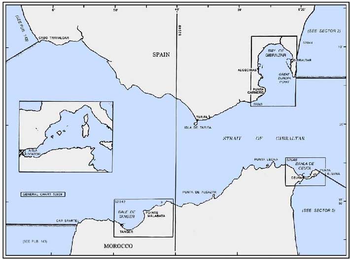
Plan. – This sector first describes the N side of the Strait of Gibraltar from Cabo Trafalgar (36°11'N, 6°02'W) to Great Europa Point (36°06'N, 5°21'W). It then describes the S side of the strait from Cap Spartel (35°37'N, 5°56'W) to Punta Almina (35°54'N, 5°17'W).
General Remarks
1.1 The Strait of Gibraltar is bounded on the N side by the coast of Spain and Gibraltar, a dependent territory of the United Kingdom; it is bounded on the S side by the coast of Morocco and the Spanish towns of Cueta and Melilla.
Tides – Currents. – In the middle of the strait, the E current commences at about the time of HW at Gibraltar and the W current about 6 hours later. As the shores are approached on either side, the times at which these currents commence becomes progressively earlier as indicated by the series of dashed lines on the chart. In the central area of the W part of the strait, the current attains a rate of 1 knot S of Cabo Trafalgar and 1.7 knots S of Punta Camarinal (36°05'N, 5°48'W). In the central and narrower area of the E part of the strait between Isla de Tarifa (36°00'N, 5°37'W) and Europa Point (36°06'N, 5°21'W), the currents attain rates up to 2 knots in each direction. Rates increase from the central areas towards the shores on both sides of the strait and currents attain rates up to 3 knots in each direction inshore. In the central area, the currents set in the direction of the axis of the strait, but near the land they generally follow the direction of the coast.
Tidal races or overfalls may occur in the deep water within the strait. Tidal races also occur off most of the salient points and eddies form in the bays between them. On the N side of the strait, a tidal race, known as Riza del Cabo, extends SW from Cabo Trafalgar to Bajo Aceitera, 1.8 miles SW. This race is always present, whatever the state of tide, and its strength depends on whether it is springs or neaps. It is reported to be the most violent race within the strait. During heavy weather and when the tidal current is running strongly, this race may extend as far SW as Banco del Hoyo.
During the strongest period of the tidal current, a race of considerable violence forms over and in the vicinity of Bajo de Los Cabezos (36°01'N, 5°42'W). In heavy weather, it may extend entirely across the strait.
Comparatively smaller races also occur off Isla de Tarifa, Punta de Cala Arenas (36°03'N, 5°27'W), close E of La Perla, and Europa Point.
On the S side of the strait, strong tidal races occur off Cap Spartel and 4 miles E of Pointe Judios. Overfalls, resembling breakers, occur N of Tanger (35°47'N, 5°48'W). Small races occur off Pointe Ciris (35°55'N, 5°29'W) and all the other salient points located E of Punta Almina (35°54'N, 5°17'W).
During the strongest period of the tidal current in each direction, the most violent races occur off the coast and over the banks between Pointe Malabata (35°49'N, 5°45'W) and Hejar Lesfar (3.2 miles ENE).
Traffic Control. – An IMO-adopted Traffic Separation Scheme (TSS), which may best be seen on the chart, is situated within the narrows of the strait and in the W approaches.
A mandatory Vessel Traffic Service is in operation in the Strait of Gibraltar, including the TSS and Inshore Traffic Zones. The following categories of vessels are required to participate in the reporting system:
- All vessels 50m long and over.
- All vessels, regardless of length, carrying hazardous and/or potentially polluting cargo.
- Vessels engaged in towing or pushing another vessel when the combined length of the vessel and tow or pushed vessel is over 50m.
- Any category of vessel less than 50m long and engaged in fishing in the Traffic Lane or the Separation Zone.
- Any category of vessel less than 50m long which is using the appropriate Traffic Lane or Separation Zone in order to avoid immediate danger or engage in fishing.
The reporting system covers the area between longitudes 5°58'W and 5°15'W
This area includes the Traffic Separation Scheme in the Strait of Gibraltar, the Precautionary Areas, and the designated Inshore Traffic Zones.
The report, called a GIBREP, sent from the vessel to the Tarifa VTS Center, should contain only information which is essential to achieve the objectives of the system.
| GIBREP Information | |
|---|---|
| Designator | Information required |
| A | Vessel’s name and call sign. IMO Identification Number on request. |
| C | Position (latitude and longitude), or |
| D | Range and bearing from a landmark. |
| E | Course. |
| F | Speed. |
| G | Last port of call. |
| I | Next port of call. |
| P | Hazardous cargo, IMO class, or UN number and quantity |
| Q or R | Breakdown; damage and/or deficiencies affecting the structure, cargo, or equipment of the vessel; or any other circumstances affecting normal navigation, in accordance with the provisions of the SOLAS and MARPOL Conventions. |
Tarifa VTS broadcasts regular warnings to mariners and traffic, navigational, and weather conditions, in Spanish and English .
Tarifa Traffic can also provide a particular vessel with information regarding the vessel’s position, course and speed, or the identification of traffic in the vicinity. The vessel should request this information.
Caution. – Local magnetic anomalies have been reported in the approaches to the strait.
Several submarine cables lie within the Strait of Gibraltar and may best be seen on the chart.
Tunny nets may be found at certain seasons of the year extending up to 7 miles seaward from the shores bounding the Strait of Gibraltar.
Submerged tunny nets lying off the coasts of Spain and Africa, under Spanish jurisdiction, are indicated by the following:
- By day – A white flag, with a black letter A at the center, displayed from a boat or buoy moored at the center and outer end of the net.
- By night – A red light above a white light shown from a boat or buoy moored at the outer end of the net, and two vertical white lights shown from a boat or buoy moored at the center of the net. These lights are visible from about 2 miles.
The Strait of Gibraltar – North Side
1.2 Banco del Hoyo (36°05'N, 6°15'W), a sandy bank, has depths of 16 to 22m and lies 14 miles WSW of Cabo Trafalgar. This bank extends for about 5 miles in an E-W direction and the least depths lie near its W end. It should be avoided in heavy weather as the sea is apt to break over it.
Banco de Trafalgar (36°08'N, 6°07'W), a shoal composed of stones, has a least depth of 6.6m and lies 5 miles SW of Cabo Trafalgar. There are overfalls on this shoal and it is inadvisable to pass over it in heavy weather. At such times, the water in the vicinity is of a yellowish color.
Placer de Meca (36°11'N, 6°06'W), a rocky shoal, lies 3.2 miles W of Cabo Trafalgar and has a least depth of 5m near its SE end. This shoal is covered with a thin layer of sand and the sea breaks over it in heavy weather.
Bajo Aceitera (36°10'N, 6°04'W) has a depth of 1.2m and lies at the outer end of a dangerous rocky ridge which extends up to 1.7 miles SW of Cabo Trafalgar. A passage leads between the shoal and the cape, but it should not be attempted. Broken water extends across this shoal and a tidal race in its vicinity is caused by the unevenness of the bottom.
Bajeta de Fuera and Los Cabezos (36°01'N, 5°43'W) lie close together, 3.5 miles SSE of Punta Paloma. Several wrecks, some dangerous, lie in this vicinity and the sea breaks heavily on these shoals during SW gales. A wide berth should be given to this area.
La Perla (36°04'N, 5°25'W), a dangerous group of pinnacle rocks, lies 1.2 miles S of Punta Carnero and has a least depth of 4.7m. Las Bajas, a rocky shoal with a minimum depth of 11.6m, lies close E.
1.3 Cabo Trafalgar (36°11'N, 6°02'W), 20m high, is formed by a small, sandy, and uneven peninsula which is connected to the mainland by a low and sandy isthmus. When seen from the NW or SE, it appears like an island.
 |
Cabo Trafalgar |
A light is shown from a prominent tower, 51m high, standing on the cape. A radiobeacon is situated at the light. Torre de Meca, a conspicuous round tower, stands 1.3 miles NE of the cape.
Arrecife del Canaveral, a drying reef, extends up to 0.3 mile offshore, 1.3 miles E of Cabo Trafalgar. Anchorage, with shelter from N winds, can be obtained by small vessels, in depths of 14 to 16m, between Arrecife de Canaveral and the cape. There is good holding ground, but the nature of the bottom should first be ascertained as it is rocky in places.
Picacho de Barbate (36°12'N, 5°58'W), a sharp peak, is very conspicuous and has a high white spot which is visible from seaward.
Ensenada de Barbate, a bay, is entered between Punta del Tajo (36°10'N, 5°59'W) and Punta de Zahara, 6.5 miles SE. The Rio Barbate enters this bay 3.2 miles E of Punta del Tajo and is fronted by a shallow bar. The town of Barbate stands on the W bank of this river. Bajo de Zahara, a shoal, has a least depth of 8.5m and lies 1 mile S of the mouth of the river.
A small harbor, protected by breakwaters, is situated 1 mile W of the river mouth . It has shallow depths and is mostly used by fishing vessels and recreational craft with local knowledge. During offshore winds, vessels may obtain anchorage within the bay in any convenient location; however, anchorage is unsafe with winds from seaward. A light is shown from a tower, 22m high, standing close NE of the harbor.
Between April and August, tunny nets are laid 1 mile S of the harbor entrance.
1.4 Ensenada de Zahara (36°07'N, 5°51'W), a bight, lies 6 miles SE of Barbate. Anchorage may be obtained in this bight, sheltered from Levanters (E winds), but heavy squalls come off the land. The bottom of the bight is generally sandy, but with some rocks. Several rocky patches lie close inshore and front the sandy beach in the N part of the bight.
Punta de Gracia is located 2 miles SE of Ensenada de Zahara and is formed by the extremity of a high spur. A light is shown from a conspicuous tower, 75m high, standing on this point.
Punta Camarinal (36°05'N, 5°48'W), located 1 mile SE of Punta de Gracia, is low, rounded, and prominent. It rises to Sierra de la Plata, a steep and prominent ridge.
Ensenada de Bolonia, a small bay, is entered 1 mile E of Punta Camarinal and affords good shelter from winds from the NW through N to E. Depths of 9 to 11m lie up to 0.4 mile offshore in the bay, but the nature of the bottom should be ascertained before anchoring, as it is rocky in some places.
1.5 Punta Paloma (36°04'N, 5°43'W) is located 4.5 miles ESE of Punta Camarinal. A light is shown from a building, 45m high, standing on this point, but the light structure is reported to be difficult to identify as it is similar to other buildings in the vicinity.
Sierra de San Bartolome (36°05'N, 5°43'W), 450m high, stands 2 miles N of Punta Paloma and is conspicuous because of the numerous peaks at its summit. A long, bare patch of yellow sand, which commences at the NW side of Punta Paloma, rises to a position about halfway up this mountain and then descends to terminate near the head of Ensenada de Valdevaqueros, 1.5 miles E.
Ensenada de Valdevaqueros (36°04'N, 5°41'W), a small bay, affords good anchorage with shelter from NE winds. A good berth lies, in depths of 8 to 10m, near the beach at the head of the bay.
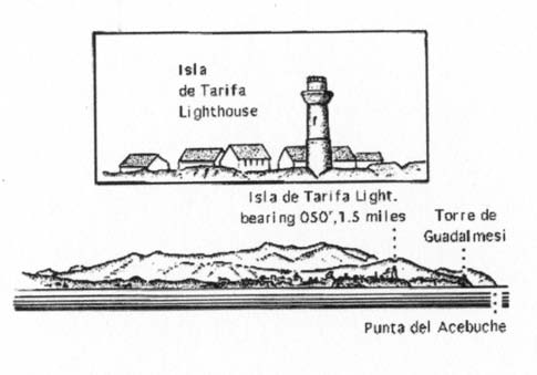
Isla de Tarifa (36°00'N, 5°37'W) is flat, of moderate elevation, and is joined to the mainland by a causeway. A light is shown from a conspicuous tower, 33m high, standing on the S part of the island. A racon and a radiobeacon are situated at the light.
A conspicuous water tower stands on the mainland, 1.4 miles NNE of the light. A prominent signal station stands on Castillo de Santa Catalina, at the head of the causeway.
1.6 Tarifa (36°01'N, 5°36'W) (World Port Index No. 38300 ), a small port, is situated on the mainland, close NNE of Isla de Tarifa. The harbor, protected by two breakwaters, fronts an old walled city. It is used by small naval vessels, fishing vessels, and ferries. A hydrofoil craft service is reported to operate from here to Tangier. In addition, the roadstead anchorage can accommodate large vessels.
Tides – Currents. – Tides rise 1.4m at springs and 1m at neaps.
The tidal currents set W on the flood and E on the ebb.
Depths – Limitations. – The entrance to the harbor is 100m wide. The inner side of the E breakwater provides 460m of total berthing space with depths of 4 to 8m alongside. A ro-ro berth is situated at the elbow. Muelle No. 1, at the inner side of the W breakwater, has 217m of space with depths of 3 to 4m alongside. It is mostly used by ferry vessels. Muelle No. 2, 135m long, has depths of 3 to 4m alongside and is used by fishing vessels. The small basins at the N side of the harbor are used by naval craft.
Anchorage. – Large vessels can obtain temporary anchorage, over a bottom of sand and gravel, E of the head of the E breakwater. Local knowledge is advised.
1.7 Punta Camorro (36°01'N, 5°35'W), located 1 mile ENE of Tarifa, is high, steep, and of a whitish color. It is readily distinguished from the W.
 |
Tarifa |
Punta Guadalmesi, located 3.2 miles ENE of Punta Camorro, is formed by a bold, grayish cliff. A prominent tower stands on its summit.
Ensenada del Tolmo is entered between Punta Guadalmesi and Punta del Acebuche, 3 miles E. It is bordered by a white sandy beach on which lie numerous rocks. A castle, in ruins, stands on a hillock, 1 mile W of Punta del Acebuche. Prominent Guardia Civil stations stand on the W side of the mouth of a stream, which lies 0.7 mile W of the castle, and 0.3 mile W of Punta del Acebuche. During offshore winds, this bay affords good anchorage, in depths of 10 to 13m, to small vessels. Punta del Acebuche is low, but is easily identified from the E or W. Dos Hermanas, two black above-water rocks, lie about 0.3 mile E of this point.
Punta de Cala Arenas is located 1 mile ENE of Punta del Acebuche and surmounted by the ruins of a castle. Canillas, 307m high, stands 1 mile WNW of the point and a radio mast is reported to stand on its summit. Torre de Fraile, a prominent tower, stands on the hillside, 0.2 mile W of the point.
Cala Arenas, a cove, lies close E of Punta de Cala Arenas and has a sandy beach at its head. It affords anchorage, in depths of 3 to 5m, sand, to small vessels with local knowledge.
The coast between Cala Arenas and Punta Carnero, 1.5 miles NE, is fronted by rocks and is generally foul. Isla de las Palo-mas, a low and barren islet, lies 0.3 mile offshore, 0.7 mile NE of Punta de Cala Arenas. Numerous rocks lie between the islet and the shore.
The Bay of Gibraltar
1.8 The Bay of Gibraltar (36°08'N, 5°24'W) is entered between Punta Carnero and Europa Point, 4.5 miles ENE. It extends N for 5.5 miles and is bordered on the E side by the Rock of Gibraltar. This bay is entirely open to the S; depths of over 200m extend up to 4 miles into it.
 |
|
The Bay of Gibraltar – Entrance |
Europa Point, the E entrance point, presents a cliffy face, 0.3 mile wide.
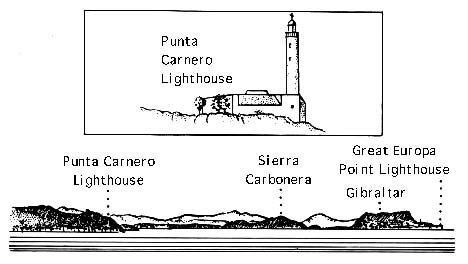
Great Europa Point (36°07'N, 5°21'W) is the SE termination of this cliffy face. A light is shown from a prominent tower, 19m high, standing on this point. A conspicuous radar dome is situated 0.5 mile N of the light.
Punta Carnero (36°04'N, 5°26'W), the W entrance point, is formed by the E termination of a range of hills and has a steep SE slope. It is fronted by dangers which extend up to 0.2 mile offshore. A light is shown from a tower, 19m high, standing on the point. A prominent tower stands 0.2 mile W of the light.
A dangerous wreck lies about 0.2 mile offshore, 0.3 mile NNE of this point.
Caution. – Because of a strong NW to NE set caused by tidal currents along the coastline of Punta Carnero, sailing close to shore is not recommended. Numerous accidents have occurred here due to the strong currents.
Ensenada de Getares is entered between Punta Carnero and Punta de San Garcia, 1.8 miles N. Anchoring is prohibited in the bay as best seen on the chart.
A conspicuous coast guard station stands on Punta de San Garcia.
Punta del Rodeo is located 0.5 mile N of Punta de San Garcia and is fronted by dangers which extend up to 0.2 mile offshore.
Mar de Isidro, with a least depth of 15.8m, lies about 1 mile ESE of Punta del Rodeo and is marked by a lighted buoy.
Numerous submarine cables, which may best be seen on the chart, lie in the entrance to the Bay of Gibraltar and in the vicinity of Ensenada de Getares.
World Port Index No. 38310
1.9 Algeciras lies on the W side of the Bay of Gibraltar, 3 miles N of Punta Carnero. The port is situated SW and NW of Isla Verde, a former island, which has been connected to the mainland by extensive reclamation. The port authority also administers marine installations at the head of the Bay of Gibraltar.
Port of Algeciras Home Page
Tides – Currents. – Tides rise 1.1m at springs and 0.9m at neaps.
Depths – Limitations. – Dique Norte, the main outer breakwater, extends about 1 mile N from the reclaimed land adjoining Isla Verde. Its inner side has 1,500m of total berthing space, with depths of 12 to 16m alongside, which is mainly used for bunkering.
Other main facilities include the following:
- Muelle de la Isla Verde, in the S part of the harbor, is used by general cargo, container, and ro-ro vessels. It has 980m of total berthing space with depths of 9 to 12m alongside.
- Muelle de la Galera South, in the SW part of the harbor, is used by ro-ro, ferry, and passenger vessels. It has 640m of total berthing space, with depths of 6 to 10m alongside.
- Muelle de la Galera North is mainly used by general cargo and reefer vessels. It has 280m of total berthing space, with a depth of 10.5m alongside.
- Muelle del Navio (Muelle Juan Carlos I), in the central part of the harbor, is used by container, bulk, and general cargo vessels. It has1,900m of total berthing space, with depths of 10.5 to 14m alongside. Terminal 2000, located on the N part of Muelle del Navio, is 644m long, with a depth alongside of 16m.
A buoyed channel, dredged to a depth of 7m has been established N of Muelle del Navio. It leads from the causeway connecting Muelle deL Navio with the mainland into the bay W of Anchorage Area B.
An lighted offshore SBM tanker berth lies in a depth of 60m, 1 mile SSW of Punta del Gallo. Several hoses, 290m long and marked by orange lights, are attached to the buoy. Three submarine pipelines extend NNE from the berth to the shore. Anchorage is prohibited within 550m of the SBM and within 150m of the pipelines as shown on the chart. Tanker vessels up to 500,000 dwt and 30m draft can be accommodated at this offshore terminal The buoy is equipped with a radar reflector and a racon.
There is also an extensive basin in the W part of the harbor for the use of fishing vessels.
Generally, vessels up to 14m draft can be accommodated and there are no restrictions for length or beam.
Aspect. – A fort and a tank farm are situated on Isla Verde. In addition, several slipways and workshops stand on the S side of this former island.
Numerous conspicuous white houses stand along the waterfront of the town. A church, with a prominent tall steeple, stands in the town.
Pilotage. – Pilotage is compulsory for merchant vessels of over 50 grt entering the Bay of Gibraltar and proceeding to Algeciras. Pilots can be contacted on VHF channel 13 and board about 2.2 miles SE of the head of Dique Norte. During E storms, pilots generally wait inside the head of the breakwater.
Vessels proceeding to the refinery or CEPSA monobuoy at the head of the bay should send an ETA and request for pilot 72 hours, 48 hours, and 24 hours in advance. If required, pilots may be conveyed by helicopter and vessels should contact the Helicsa helicopter service.
Caution. – A prohibited anchorage area, the limits of which may be seen on the chart, E and S of the former Isla Verde.
A submarine pipeline extends 0.4 mile E of former Isla Verde.
A shoal area lies close NNW of the harbor entrance and is marked by a lighted buoy.
The Bay of Gibralter – Head
1.10 Punta del Rinconcillo (36°09'N, 5°27'W), surmounted by a prominent coast guard station, is located 1.6 miles N of Isla Verde. Torre del Almirante stands on a cliff, 0.3 mile S of the point. This conspicuous reddish tower is partially in ruins. Ermita del Baleares, a conspicuous building, is situated 0.3 mile W of Punta del Rinconcilla and is visible from all parts of the bay.
Depths of less than 5m lie up to 0.5 mile SE of Punta del Rinconcillo.
Torre de Entre Rios, a square and dark tower, stands on a hill, 1.5 miles NNE of Punta del Rinconcillo. The Rio Palamones flows into the bay close S of this prominent tower and a conspicuous hotel stands near its mouth .
Puerto Acerinox (36°10'N, 5°25'W) is situated 0.5 mile E of Torre de Entre Rios. It consists of a small harbor basin which is protected by a large L-shaped breakwater. The Muelle de Levante, used for handling scrap metals, is situated at the E side of the basin. It is 250m long and has a depth of 9.5m alongside.
A bulk and coal berth, 360m long, extends along the outer side of the breakwater. It has depths of 23 to 30m alongside and can accommodate vessels up to 270,000 dwt.
Punta del Gallo (36°11'N, 5°24'W), fronted by rocks, is located 1 mile E of Puerto Acerinox. A round fort stands on this point.
San Roque is situated 2 miles NNE of the point. This city is very prominent as it stands on high ground.
A conspicuous oil refinery, with its associated tanks and prominent chimneys, stands close N of Punta del Gallo. A power station, with several conspicuous chimneys, is situated 0.7 mile E of the refinery.
1.11 CEPSA Oil Terminals (36°11'N, 5°24'W) are situated at the head of the bay.
A T-head pier, which extends 400m from the shore, is situated 0.3 mile E of Punta del Gallo. Its head is 700m long and has five berths. Tanker vessels up to 315m in length and 20m draft can be accommodated alongside.
Pilotage for the above terminals is compulsory and is provided at the port of Algeciras. A mooring master and crew will board vessels in the vicinity of the SBM.
 |
CEPSA Oil Terminals |
Puente Mayorga (36°11'N, 5°23'W), a town, is situated 1 mile E of Punta del Gallo. Its conspicuous white houses form a good landmark when approaching the terminals at the head of the bay. A prominent shipyard is situated on reclaimed land, 0.5 mile SSE of the town.
Puente Mayorga Water Terminal (36°11'N, 5°23'W), consisting of six dolphins, lies 0.2 mile S of the town. A submarine pipeline, with a floating connection, extends NNE from the offshore berth to the shore. Vessels up to 115,000 dwt and 18m draft can be handled.
1.12 La Linea de la Conception (36°10'N, 5°21'W), situated 2 miles SE of Puente Mayorga, is served by Muelle de San Felipe, a jetty, which extends 650m WSW from the shore. This jetty has depths of 3 to 5m alongside and is used by passenger and fishing vessels. It is protected on the S side by a breakwater which extends 1,150m W, 310m NW, and then 170m N. A circular prohibited area of radius 450m is centered at the N extremity of Dique de Abrigo, as seen on the chart.
Anchorage. – Vessels wishing to anchor within the bay without the assistance of a pilot must first contact the pilot station by VHF. The station will indicate the most suitable anchorage berth, taking into consideration such factors as the weather, size of vessel, draft, length of stay, class, etc.
Three anchorage areas, designated A, B, and C and best seen on the chart, have been established in the Bay of Gibraltar.
World Port Index No. 38330
1.13 Gibraltar, a remarkable mountainous promontory, known generally as the Rock of Gibraltar, rises abruptly on the N side of the E end of the Strait of Gibraltar. The N and E sides of this promontory are precipitous and the S side is formed by several successive short terraces which terminate in a cliff at Europa Point. The W side, on which stands the town, falls in rugged slopes.
The steep, inaccessible E, or Mediterranean, side of the Rock of Gibraltar is marked by a conspicuous rainwater catchment device situated 1.5 miles N of Great Europa Point. A low sandy isthmus connects the N side of the Rock to the mainland. The airport, with its runway extending into the bay, occupies the S side of this isthmus, close S of the boundary with Spain.
The port is situated on the W side of the Rock of Gibraltar and fronts the town. It is composed of a commercial harbor, a navy base, and a ship repair complex.
Winds – Weather
With W winds, cold front squalls may be severe. Heavy thundershowers often develop after the passage of a cold front. Intense down currents occur E of the Rock during a strong W flow. During W gales, gusts of over 70 knots have been experienced on Windmill Hill. During E gales, gusts of 60 knots have been reported.
Tides – Currents
Tides rise 1m at springs and 0.7m at neaps.
The N current sets into the principal harbor area by way of South Entrance. It sets out by way of North Entrance and the viaduct at North Mole. The S current sets into the harbor by way of North Entrance and the viaduct. It sets out through South Entrance.
In the vicinity of South Entrance, the flow is more or less in the direction of a line which joins the mole heads. As there is generally little or no flow inside the entrance, the sterns of vessels entering, or the bows of vessels leaving, should be swung towards Detached Mole with a N current and towards South Mole with a S current.
In North Entrance, the direction of flow is more or less in a direction at right angles to a line which joins the mole heads. Vessels entering or leaving will usually be slightly assisted or retarded by the flow. However, if vessels enter or leave obliquely, a strong set towards Detached Mole may be experienced with a S current or a weak set towards North Mole may be experienced with a N current. All these effects may be modified by eddies which form off the mole heads.
Within the principal harbor area, the flow is weak and irregular, but with a general tendency N or S according to the direction of the current outside. At times, there may be a flow in a counterclockwise direction around either the N or S half of the harbor. The presence of large ships and their movements in the harbor may cause considerable changes.
Caution is required when passing through either North Entrance or South Entrance, due to the effect of the currents. Some idea of the direction of the current may be formed by observing how vessels at anchor outside the harbor area are aligned.
Depths – Limitations
The harbor is enclosed by three moles. North Mole extends W and S from the N part of the port. The North Entrance is 200m wide and lies between the S extremity of North Mole and the N extremity of Detached Mole. South Mole extends 0.6 mile NW from the S part of the port. The South Entrance is 180m wide and lies between the S extremity of Detached Mole and the N extremity of South Mole.
The commercial and bunkering facilities are situated in the N part of the harbor. The extensive repair yards and drydocks, which can handle vessels up to 75,000 dwt, are situated in the S part of the harbor. An area lying close N of North Mole has facilities for small craft and yachts.
The main commercial facilities are described in the accompanying table.
In addition, there is 790m of berthing space alongside the inner side of Detached Mole. Vessels up to 420m in length, with a maximum draft of 9m, can be accommodated. Vessels with deeper drafts may be accommodated for short durations on a half-tide basis. The harbor has facilities for cargo, bunkering, passengers, petroleum, container, and ro-ro vessels.
Aspect
An aeronautical radiobeacon and an aeronautical light are situated at an elevation of 405m, on the N part of the Rock of Gibraltar, 2 miles N of Great Europa Point.
Prominent landmarks when approaching the harbor include the following:
- The Casino, a large white building floodlit at night, standing 1.2 miles N of Europa Point.
- The Rock Hotel, a white building, standing close N of the Casino.
- The dockyard clock tower, illuminated at night, situated 0.4 mile SSW of the Rock Hotel.
- The dockyard tower standing at the NW end of the main quay, 0.2 mile W of the Rock Hotel.
- The Lloyd’s Signal Station standing on Windmill Hill, 0.4 mile N of Europa Point.
Pilotage
Pilotage is compulsory for all vessels except those outbound from the anchorage. Pilots may be contacted on VHF channel 12, 14, or 16 and generally board about 0.7 mile W of Europa Point. During bad weather, pilots may board about 1.2 miles NW of the point. Vessels should send an ETA 24 hours in advance and a confirmation 2 hours before arrival. All vessels underway or at anchor in the bay must maintain a listening watch on VHF channel 12.
|
Gibraltar – Main Commercial Facilities |
|||
|---|---|---|---|
| Berth | Length | Depth alongside | Remarks |
| Western Arm Quay West | 490m | 9.3m | Maximum draft of 9.6m |
| Western Arm Quay East | 450m | 9.1m | Maximum draft of 8.5m |
| Jetty No. 1 | 200m | 8.7-8.9m | |
| Jetty No. 2 | 100m | 8.7m | |
| Jetty No. 3 | 245m | 11.1m | |
| Jetty No. 4 | 200m | 7.6-7.7m | |
| Jetty No. 5 | 120m | 7.8m | |
Pilots may be conveyed by helicopter and if required vessels should contact Helicsa helicopter service.
The Lloyd’s Signal Station on Windmill Hill will accept reports from vessels transiting the Strait of Gibraltar.
Regulations
Regulations for the control of Admiralty Waters and Port Waters (Commercial Port) are in effect. According to the regulations, vessels other than British Naval Vessels may not enter the principal harbor area, known locally as Admiralty Waters, without the permission of the harbormaster.
Signals
The signals described in the accompanying table are displayed from the dockyard tower when vessels, other than naval vessels, are about to enter or leave the berths on the North Mole, Detached Mole, or Western Arm.
| Gibraltar – Signals | ||
|---|---|---|
| Meaning | Day signal | Night signal |
| Vessel is entering | Red square flag over Flag I | Two red lights, horizontally disposed |
| Vessel is leaving | Red square flag over Flag O | Two green lights, horizontally disposed |
Anchorage
Commercial vessels usually anchor W of North Mole, Detached Mole, and South Mole, but clear of the prohibited anchorage area.
Smaller vessels can anchor inshore according to their draft. Caution is necessary when approaching this anchorage area as the tidal currents may be strong.
Caution
Anchorage is prohibited within an area, the limits of which are shown on the chart, extending up to 1.2 miles W of the W end of the airport runway. A lighted float is moored within this area.
A prohibited area, the limits of which are shown on the chart, extends up to 0.5 mile W of the W end of the airport runway.
Winds from the SW blow directly into the bay and a heavy sea may be experienced in the anchorage area.
Several isolated patches of foul ground are known to exist within an the area extending up to 1 mile seaward of the South Mole.
Several submarine cables lie in the vicinity of the harbor and may best be seen on the chart.
Several mooring buoys are situated within the harbor.
Several wrecks lie in the approaches to the harbor and may best be seen on the chart.
In bad weather, a swell sometimes enters South Entrance and is accompanied by violent squalls. At such times, additional precautions in securing alongside may be required.
Caution is required when entering the harbor through South Entrance, due to the tidal currents which run across the fairway.
Passing vessels should remain well clear of the entrances to the harbor.
The Strait of Gibraltar – South Side
1.14 Off-lying dangers. – Banco Majuan (35°55'N, 5°59'W), an extensive bank, lies 7.5 miles NNW of Cap Spartel and has a least depth of 50m.
Lajas de Spartel, which frequently breaks, consists of two rocks which lie 0.5 mile W and 0.7 mile WSW of Cap Spartel.
Banco de Fenix (35°52'N, 5°43'W), the principal danger on the S side of the strait, lies 3 miles NNE of Pointe Malabata. It consists of a number of rocky heads and has a least depth of 15.3m.
Cap Spartel (Cap Espartel) (35°47'N, 5°56'W) is the NW extremity of Africa and the SW limit of the Strait of Gibraltar. It is dominated by Jebel Quebir, 326m high, which is the summit of a range of hills extending from Tanger. The cape terminates seaward in an enormous black hummock-shaped rock. When seen from the N or S, this rock appears as an islet. A conspicuous tower stands on the summit of Jebel Quebir. The high land above the cape is rendered prominent from the NW by two long vertical patches of grey rock which are located about a third of the way down from the summit.
A light is shown from a prominent tower, 24m high, standing on the cape. A radiobeacon is situated close SW of the light.
A dangerous stranded wreck lies 0.5 mile S of the light.
Caution. – It is reported that a depression in the land lying to the S of the cape is liable to be mistaken at night for the entrance to the Strait of Gibraltar when the low land cannot be seen. Caution is advised in this vicinity and vessels should note the depths by sounding continuously. Vessels should remain at least 1 mile off the coast when rounding the cape.
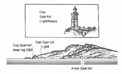 |
Cap Spartel |
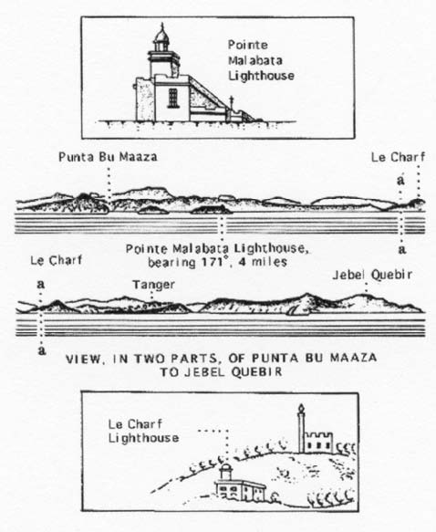
1.15 Ras Bousaboun (Pointe des Juifs) (35°48'N, 5°51'W), located 4 miles E of Cap Spartel, can be identified by its conspicuous white cliffs. Anse Judios, a cove, lies 0.7 mile ESE of the point. The Rio de Los Judios flows through a valley into this cove. The valley separates the high land on the E side of Cap Spartel from Plateau du Marshan. This prominent break in the land can be identified even at night in clear weather.
Pointe Malabata (35°49'N, 5°45'W) is a bold, prominent headland which terminates in steep cliffs. A light is shown from a prominent tower with a dwelling, 18m high, standing on the summit of the cliffs. A prominent disused battery is situated close to the light. Vessels should not normally approach this point closer than 1 mile.
Almirante Rock, which is generally indicated by a swell, lies about 0.5 mile N of Pointe Malabata and is marked by a lighted buoy. It has a least depth of 6.3m and breaks in heavy seas.
Tangier Bay (Baie de Tanger) (35°48'N, 5°47'W) is entered between Pointe Amaier, located 1.2 miles E of Pointe des Juifs, and Pointe Malabata, 4 miles ENE. It is mostly bordered by a sandy beach and backed by high land. The port of Tanger occupies the W side of this bay.
Sevil du Burj, a shoal with a least depth of 3.6m, lies in the E part of the bay, about 1 mile SSW of Pointe Malabata. Gandouri Shoal, with a least depth of 5.5m, lies about 0.7 mile SW of Sevil du Burj.
Tanger (Tangier) (35°47'N, 5°49'W)
World Port Index No. 45755
1.16 The port of Tanger lies on the SW side of Tangier Bay and is protected by an outer breakwater which extends 0.6 mile NE and E from a point on the shore, 1 mile ESE of Pointe Ammaier.
Winds – Weather. – From October to May, the prevailing winds are generally from the W to SW. From May to October, they are from the E to NE and are often very strong.
Tides – Currents. – Tides rise 2.4m at springs and 1.9m at neaps.
Depths – Limitations. – The port is entered between the breakwater, on the N side, and a mole, which has been built on a large reclaimed area, on the S side. It is composed of an inner and an outer harbor. The inner harbor lies between the root of the breakwater and the root of the mole, and is used mainly by fishing boats and small craft.
The main facilities in the outer harbor include a quay, situated at the inner side of the breakwater, which has 600m of total berthing space and depths of 6.2 to 9.5m alongside; a tanker berth, situated at the outer end of the breakwater, which has a face 72m long, with a depth of 12m alongside; a ferry pier, 135m long, with a depth of 6.5m alongside; Mole de Commerce, with Berths C1-2 and Berths P1-5, with 700m of berthing space and depths alongside from 2.5 to 12m; and Quai No. 2, situated at the N side of the mole, with 620m of total berthing space and depths of 6 to 12m alongside.
The port has facilities for tanker, container, ro-ro, ferry, passenger, and general cargo vessels with drafts up to 11.8m.
Aspect. – The W side of the bay is dominated by the harbor and the city. Conspicuous landmarks include the following:
- A water tower standing 1 mile W of the root of the breakwater.
- Le Charf, an isolated and conical hill, standing 1.5 miles S of the head of the breakwater. It is 109m high and a white house, with a minaret, surmounts the summit. A light is shown from a building, 7m high, standing on the slope of this hill, close below the summit.
- A radio mast standing 1 mile SW of Le Chart.
- A tower standing on a hill, 1.6 miles SE of the head of the breakwater. It overlooks the ruins of the old village of Tanger.
- A walled enclosure, with two white towers, situated close to the shore, 1.5 miles ESE of the head of the breakwater.
- A prison building standing 0.4 mile ENE of the walled enclosure.
 |
|
Approach to Tanger |
Prominent landmarks include the following:
- A mosque standing about 1.5 miles WSW of the breakwater head.
- The light structure, 16m high, standing on the head of the breakwater.
- Maison Gautsch, a large isolated house, stands close to the shore, 0.9 mile S of the head of the breakwater.
Pilotage. – Pilotage is compulsory for all vessels over 50 grt when entering or leaving the roadstead or the harbor.
Vessels should send an ETA at least 6 hours in advance and a confirmation message 1 hour before arrival. Pilots can be contacted on VHF channel 11 or 16 and generally board about 0.5 mile N of the head of the breakwater.
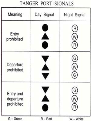
Signals. – Port signals are given in the accompanying table.
Anchorage. – The bay is the only anchorage roadstead of any importance on the S side of the Strait of Gibraltar which can be used by vessels of any size. Although exposed to N and NE winds, it affords security from winds from other directions.
Deep-draft vessels can anchor, in depths of 10 to 12m, within a designated area, the limits of which are shown on the chart, lying 0.3 mile S of the breakwater head.
During a severe E wind (Levanter), vessels can anchor, in depths of 11 to 15m, sand, close W of a small beach, about 0.5 mile SSW of Pointe Malabata. The nature of the bottom should be ascertained as it is reported to be rocky in places.
Caution. – Buoree Rock, with a least depth of 0.9m, lies about 1 mile E of the head of the breakwater and is marked by a lighted buoy.
There is heavy fishing vessel and ferry traffic in the approach to Tanger. A dangerous wreck, marked by a lighted buoy, lies about 0.5 mile ENE of the head of the breakwater. Tanger is the only place in Morocco, between Cap Spartel and Ceuta (35°54'N, 5°19'W), where landing is permitted.
The channel leading between Pointe Malabata and Almirante Rock should not be used by deep-draft vessels except in cases of necessity.
Several submarine cables, which may best be seen on the chart, lie within the bay and anchorage is prohibited in their vicinity. A prohibited anchorage area, the limits of which are shown on the chart, extends up to 0.4 mile E from the harbor entrance. A hydrofoil ferry is reported to run between Tanger and Tarifa.
Navigational aids have been reported (1993) to be unreliable in the approaches to and in the port. Aids may be missing, unlit, out of position, or not as charted.
1.17 Punta Altares (35°50'N, 5°43'W) is located 1.5 miles NE of Pointe Malabata and is the termination of a steep triangular cliff.
Punta Alboassa (Bou Maaza) is located 1.5 miles NE of Punta Altares. It rises steeply to Monte Khandak Zrarah, 237m high, which has a prominent conical summit. From the E or W, this point appears as a bold, rounded, and rocky headland.
Cala Grande, a bight, is entered 1.7 miles E of Pointe Alboassa. Small vessels, with local knowledge, can obtain temporary anchorage, in depths of 16 to 18m, about 0.5 mile off the beach at the head of this bight, but there is no shelter from offshore winds and the tidal currents are strong.
Monte San Simonito, 246m high, stands 2.5 miles SSE of Cala Grande, and has two peaks. It can be easily distinguished from the surrounding mountains by its form.
A number of prominent buildings stand on this point. A cove, with a sandy beach, lies close E of the point and affords excellent shelter from W or SW winds for small vessels with local knowledge. Depths of 10m lie up to 0.2 mile off the beach .
Punta de Alcazar (Ksar es Sghir) (35°51'N, 5°34'W), located 4.5 miles E of Cala Grande, is a high and salient point fringed by rocks.
A light is shown from the head of a pier, 75m long, which extends E from Punta de Alcazar.
1.18 Tanger-Mediterranean (35°54'N, 5°30'W), a new port, is protected to the N and W by a curved main jetty 2,056m long and to the E by another curved jetty 582m long.
Port of Tanger-Med Home Page http://www.tangermed.ma
Depths – Limitations. – The entrance channel is about 300m wide and should be dredged to 17m between the heads of the two jetties. There is 2,500m of berthing space available, with depths of 12 to 18m alongside.
Pilotage. – Pilotage is compulsory for all vessels 50m long and over. The pilot will board 1.4 miles N of the light on the head of the main jetty.
Pilots can be contacted on VHF channel 6. Vessels should provide their ETA 24 hours in advance of arrival.
Anchorage. – There are three anchorages available for short periods up to 24 hours, as follows:
- Anse Grande (35° 51.1'N, 5° 40.4'W).
- Alcazar Ouest (35° 52.0'N, 5° 34.7'W).
- Alcazar Est (35° 52.0'N, 5° 33.5'W).
An additional anchorage for large vessels is located S of the Ceuta peninsula centered on position 35° 49.0'N, 5° 18.4'W
1.19 Ras Ciress (35°55'N, 5°29'W) is located 5.2 miles NE of Punta Alcazar. It rises steeply to a remarkable sharp rocky ridge, known as Monte Cires, which extends 0.6 mile S of the point. This ridge attains an elevation of 230m and from some positions appears similar to the Rock of Gibraltar. A light is shown from a tower, 8m high, standing on the point.
Islotes Cires, two above-water rocks, lie 0.2 mile N of the point and are fronted by foul ground.
Ensenada de Cires, a small bight, is entered close E of Ras Ciress. It is bordered by a sandy beach and affords temporary anchorage, in a depth of 26m, to small vessels with local knowledge.
Montana Haffa del Benatz, 476m high, stands 3.5 miles SSE of Ras Ciress. It is a conspicuous and rugged mountain, with a rounded summit, and is visible from all parts of the strait.
Punta Cruces is located 1.6 miles E of Ras Ciress and rises steeply to a peak, 0.9 mile SSW. Punta Almansa, 120m high, is located 0.7 mile ESE of Punta Cruces. It rises precipitously from the sea and has a flat top.
Ensenada de Almansa, a bay, is entered between Punta Cruces and Punta Almansa. Small vessels, with local knowledge, can obtain anchorage, in depths of 5 to 8m, sand, in the middle of this bay. It is reported to be one of the best anchorages along this part of the coast.
Isla Perejil, an island, lies close offshore, midway between Punta Almansa and Ras Leona, 2 miles ESE. It is 73m high and covered in shrubs. Small vessels, with local knowledge, can find sheltered anchorage, in depths of 11 to 14m, between this island and the mainland SE, but it should only be used in case of necessity.
Two coves are located on the E side of the island and they afford shelter to small craft with local knowledge. The channel lying between the island and the mainland is obstructed by rocks.
Ras Leona terminates in cliffs, 71m high, and is conspicuous. A ruined tower standing on the summit of this point is not easy to distinguish .
1.20 Jebel Moussa (35°54'N, 5°25'W), 850m high, stands 1.5 miles S of Ras Leona. It has a remarkable peak and is the highest mountain on the S side of the strait. Along with the Rock of Gibraltar, it serves to mark the E entrance to the strait.
Punta Benzu (35°55'N, 5°23'W) is located 1 mile ESE of Punta Leona. The Spain-Morocco border has its origin between Ras Leona and Punta Benzu and is best seen on the chart. A circular tower stands on the cliffs above the point.
Bajo de Benzus, with a least depth of 4.3m, lies 0.5 mile NE of the point.
Ensenada de Benzus, a small bay, is entered between Punta Benzus and Ras Leona. Several quarries and a number of white buildings are situated on its E side and stand out clearly against the land. Small vessels, with local knowledge, can obtain anchorage sheltered from winds between the E and W, through S, within this bay.
Punta Blanca (35°55'N, 5°22'W), located 0.8 mile E of Punta Benzu, is high, steep, and a dark reddish color. The point is surmounted by the ruins of a tower and fronted by above-water rocks.
Laja de Lana, with a least depth of 5.8m, lies about 0.3 mile NNW of the point. Bajo Susan, with a least depth of 2.1m, lies about 0.2 mile E of Laja de Lana. Laja de Maiz, with a least depth of 1.5m, lies about 0.3 mile E of the point.
An isolated rock, with a depth of 9.7m, was reported (1986) to lie about 0.2 mile NNW of Bajo Susan.
Punta Bermeja (35°54'N, 5°21'W), a reddish -colored point, is located 1 mile SE of Punta Blanca. The coast between is fronted by rocks and shoals, some above water.
1.21 Bay de Ceuta (35°55'N, 5°19'W) is entered between Punta Bermeja and Punta de Santa Catalina, 3 miles E, and is open to the N.
Montana del Renegado, 328m high, stands 0.8 mile SW of Punta Bermeja. It is surmounted by a tower and slopes gradually E to the isthmus on which the modern town of Ceuta is built. The ruins of the ancient town of Ceuta, surrounded by ruined walls, are situated on the slope of the hill, 0.5 mile W of the W end of this isthmus.
Peninsula de la Almina, located on the E side of the bay, is composed of seven small hills which ascend gradually to Monte Hacho, the largest and the highest. A conspicuous fort is situated on the summit of Monte Hacho.
Punta de Santa Catalina (35°54'N, 5°17'W), the N extremity of the peninsula, is low and is fronted by numerous high rocks. Islote Ileo, the largest of these rocks, is surmounted by the ruins of a fort. The remains of a causeway lie between the point and Islote Ileo. A depth of 9.6m lies about 0.5 mile WSW of Punta de Santa Catalina.
Bajo Isabel (35°55'N, 5°17'W), which extends up to 0.3 mile N of Punta de Santa Catalina, has a least depth of 3.6m. This rocky shoal is visible because of the clearness of the water and strong tide rips occur in its vicinity.
Punta Almina (35°54'N, 5°17'W), located 0.6 mile SE of Punta de Santa Catalina, is described in paragraph 5.3.
World Port Index No. 45730
1.22 Ceuta is located within Spanish territory at the S side of the E end of the Strait of Gibraltar.
Port of Ceuta Home Page http://www.puertodeceuta.com
Winds – Weather. – The prevailing winds are NW, SW, and W in the spring; NE and E in the summer; N and NE in the autumn; and NW and W in the winter.
Tides – Currents. – Tides rise 1m at springs and 0.8m at neaps.
Depths – Limitations. – The harbor is enclosed by two breakwaters. Dique de Poniente extends E from the shore of the bay and has a total length of 1,500m. Dique de Levante extends W from the shore of the bay and has a total length of 580m. The entrance between the breakwater heads is 300m wide.
The breakwaters have quays on their inner sides with depths up to 10.7m alongside. Muelle del Canonero Dato, situated in the W part of the harbor, has 1,119m of total berthing space with depths of 4 to 7m alongside. Muelle de Espana, situated in the S part of the harbor, has 810m of total berthing space with depths of 2.9 to 10m alongside. Pantalans Este and Oeste are two piers situated in the SE part of the harbor. They are both 178m long and have depths of 5 to 9.5m alongside.
The harbor has facilities for ro-ro, container, ferry, general cargo, passenger, LNG, and tanker vessels. In addition, there are extensive facilities for fishing vessels. Vessels up to 220m in length and 10.2m draft can be accommodated.
Aspect. – The modern and prominent city of Almina stands on the N and W slopes of Peninsula de la Almina. A radio-beacon and racon are situated at the light structure on the head of Dique de Poniente. A light is shown from Punta Almina, 0.5 mile SE of Punta de Santa Catalina. A prominent tank farm is situated on the W side of the harbor.
Pilotage. – Pilotage is compulsory. Pilots can be contacted on VHF channel 9, 12, 13, 14, 15, or 16 and generally board 0.5 mile seaward of the harbor entrance. Vessels should send an ETA at least 24 hours in advance. It is reported that vessels over 180m in length and/or 9.1m draft should send an ETA at least 48 hours in advance.
Regulations. – A Vessel Traffic Service operates in the port. The VTS can be contacted on VHF channels 10, 12, and 16 (call sign: Cueta Port Control).
Anchorage. – Vessels can anchor N of Dique de Poniente, but not E of the head. The best berth lies, in a depth of 26m, stone, about 0.5 mile NW of the head, but it is somewhat exposed.
Fresh SE winds cause a heavy sea in the bay; during W winds, heavy squalls can come down off the mountain. Vessels should be prepared to leave at the onset of such weather.
Caution. – A prohibited anchorage area, the limits of which are shown on the chart, lies on the N side of Dique de Levante and extends up to 1.3 miles N of the harbor entrance.
Several submarine pipelines lie across the entrance to the harbor and may be seen on the chart.
Several submarine cables lie in the vicinity of the E side of the approach to the harbor entrance and may best be seen on the chart.
A wavemeter buoy is moored about 0.9 mile SE of Punta Bermeja.
Tunny nets may be found in the bay from October to March. A good lookout should be kept for these nets, which are generally marked.